
The Wall of Philip Augustus is the oldest city wall of Paris (France) whose plan is accurately known. Partially integrated into buildings, more traces of it remain than of the later fortifications.
The Wall of Philip Augustus is the oldest city wall of Paris (France) whose plan is accurately known. Partially integrated into buildings, more traces of it remain than of the later fortifications.
The wall was built during the struggles between Philip II of France (called Philip Augustus) and the Anglo-Norman House of Plantagenet. The French king, before leaving for the Third Crusade, ordered a stone wall to be built to protect the French capital in his absence.
The walls were fortified from 1190 to 1213, built under the command of Philip Augustus who also contributed to the cost of building the wall. Any incoming attack from France's main military threat, the English, would arrive from the western end of the Seine and so the Louvre fortress was placed just outside the western limit of the wall. The building of the wall also had the intention to discourage further urban expansion and to stimulate the usage of undeveloped land within the walls. This area of land also had the potential to sustain a growing food supply to sustain the population in the event of a siege. The wall was however never militarily put to the test. [1]

Despite the construction during the 14th century of Charles V's wall encircling Philip Augustus' wall on the Right Bank, the latter wall was not demolished. On the Right Bank, Charles' wall in effect left the earlier wall in disuse and redundant. In 1434, it was still considered strong enough and thick enough for a cart to be driven on top.
However, Charles V's wall did not extend to the Left Bank, so the Philip Augustus' old wall was strengthened by:
In 1533, Francis I demolished the Right Bank gates and authorised the leasing of the land enclosed by the wall without authorising the demolition of the wall itself. From the second half of the 16th century, these lands were sold to individuals, and often the cause of the dismantling of large sections of the wall.
The Left Bank wall followed the same path under Henry IV. In 1590, he preferred digging ditches beyond the city outskirts to once again modernising the wall. The ditches near the Seine were used as open sewers and caused health problems so in the 17th century they were filled and replaced by covered galleries. The last remaining gates, unsuited to ever-increasing traffic, were razed in the 1680s when the wall became completely invisible.
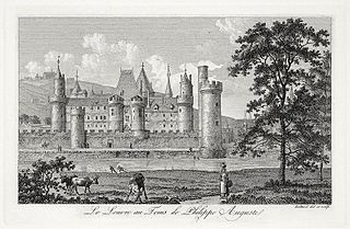
The Philip Augustus' wall enclosed an area of 253 hectares; its length was 2,500 metres on the Left Bank and 2,600 on the Right Bank. [3] The west side was the weakest point of the defence against Norman threat. Near the Seine, Philip Augustus built the Louvre castle with a fortified donjon and ten defensive towers surrounded by a moat. The construction cost was slightly more than 14,000 livres during the roughly twenty years of the construction: representing about 12 percent of the king's annual revenues in the 13th century. [3]
The wall was between six and eight metres high, including the parapet, about three meters thick at the base. It was made from two walls of large ashlar-faced limestone blocks, reinforced with an infill of rough-hewn stone rubble and mortar. The wall was topped with a crenellated two-metre wide chemin de ronde.

The wall had 77 semi-circular towers (flat and integrated into the curtain wall on the town side) at 60-metre intervals. [3] Each stood 15 metres high, with a six-metre diameter, and one-metre thick walls. The bases were vaulted but the higher floors were wooden planked.
Four huge bastion towers – 25 metres high with a ten-metre diameter – stood at the points where the wall met the Seine. Their purpose was to defend the city against assault from the river; heavy chains could be stretched across the river to prevent access.
On the west side these were:
On the east side:
Fifteen large gates opened onto the roads leading to France's main cities. At first, they were identical: an ogival gate closed with two wooden panels set into two 15-metre high and eight-metre diameter towers. Inside the gates two portcullis completed the construction.
Simple posterns – piercing the wall – were added to improve traffic flow. They could be walled up in times of danger (as could the less used or less defensible gates). However, some posterns were intended to be defended.

Philip Augustus' walls run through the 1st, 4th, 5th and 6th arrondissements of Paris.
Downstream of the Seine, the wall ended at the Tour du coin near the Louvre (Right Bank), and the Tour de Nesle (formerly Tour Hamelin) on the Left Bank. Upstream, a barrage of heavy chains across the river linked the Tour Barbeau (Right Bank) to the Tour Loriaux (on the island), linked itself to the Tournelle (Left Bank). Chains rested on rafts moored to piles driven deep into the river.

At the time of its construction, eleven main gates were laid out. Four other main gates, as well as numerous posterns, were added to reflect the city's growth. The main gates were flanked with towers, and either vaulted or left open to the sky, with gabled roofs and portcullis.
Initially, there were only five gates on the Left Bank:
In 1420, a new gate was built near Saint-Germain-des-Prés: Porte des Cordeliers (at the corner of the rue Monsieur-le-Prince and the rue Dupuytren). It was sometimes called Porte de Buci, named after an older gate further north.
Finally, at the end of the 13th century, a postern was built east of the Porte Saint-Jacques, the Porte Papale ("Pope's gate") or Porte Sainte-Geneviève at the end of the current rue d'Ulm.

At first, there were six gates on the Right Bank:
Two posterns were built between the Porte Saint-Antoine and the Seine, as well as the Barbette postern (rue Vieille-du-Temple, between the rue des Blancs-Manteaux and the rue des Francs-Bourgeois)
During the 13th century, other posterns were added:
The last gate was added in 1280:


Some sections of the wall remain visible:

Île de la Cité is an island in the river Seine in the center of Paris. In the 4th century, it was the site of the fortress of the area governor for the Roman Empire. In 508, Clovis I, the first King of the Franks, established his palace on the island. In the 12th century, it became an important religious center, the home of Notre-Dame cathedral, and the royal chapel of Sainte-Chapelle, as well as the city hospital, the Hôtel-Dieu. It is also the site of the city's oldest surviving bridge, the Pont Neuf.

Châtelet station is a station of the Paris Métro and Île-de-France's RER commuter rail service, located in the centre of medieval Paris, on the border between the 1st and 4th arrondissements. It serves RER A, B and D, as well as lines 1, 4, 7, 11, and 14 of the Paris Métro; it is the southern terminus of Line 11. The station is made up of two parts connected by a long corridor: lines 7 and 11 under the Place du Châtelet and the Quai de Gesvre, next to the Seine; lines 1, 4 and 14 towards Rue Saint-Denis and the Rue de Rivoli.

Pont Marie is a station of the Paris Métro opened in 1926 with the extension of Line 7 from Palais Royal–Musée du Louvre. It is named after the nearby bridge over the Seine, the Pont Marie, which connects to Île Saint-Louis.

Louis Tullius Joachim Visconti was an Italian-born French architect and designer.

The following is a timeline of the history of the city of Paris, France.
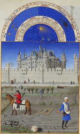
The Louvre Palace, often referred to simply as the Louvre, is an iconic French palace located on the Right Bank of the Seine in Paris, occupying a vast expanse of land between the Tuileries Gardens and the church of Saint-Germain l'Auxerrois. Originally a defensive castle, it has served several government-related functions in the past, including intermittently as a royal residence between the 14th and 18th centuries. It is now mostly used by the Louvre Museum, which first opened there in 1793.

The Pont du Carrousel is a bridge in Paris, which spans the River Seine between the Quai des Tuileries and the Quai Voltaire.

The Tour de Nesle was one of the four large guard towers on the old city wall of Paris, constructed at the beginning of the 13th century by Philip II of France and demolished in 1665.

The Palais de la Cité, located on the Île de la Cité in the Seine River in the centre of Paris, is a major historic building that was the residence of the Kings of France from the sixth century until the 14th century, and has been the center of the French justice system ever since, thus often referred to as the Palais de Justice. From the 14th century until the French Revolution, it was the headquarters of the Parlement of Paris. During the Revolution it served as a courthouse and prison, where Marie Antoinette and other prisoners were held and tried by the Revolutionary Tribunal. Since the early 19th century, it has been the seat of the Tribunal de grande instance de Paris, the Court of Appeal of Paris, and the Court of Cassation. The first of these moved to another Parisian location in 2018, while the other two jurisdictions remain located in the Palais de la Cité as of 2022.

The city walls of Paris refers to the city walls that surrounded Paris, France, as it grew from ancient times until the 20th century, built primarily to defend the city but also for administrative reasons. Several successive city walls were built over the centuries, either adding to existing walls or replacing demolished ones, through 1846, when construction of the Thiers wall was completed.
The wall of Charles V, built from 1356 to 1383 is one of the city walls of Paris built on orders granted by Charles V of France. It was built on the right bank of the river Seine outside the wall of Philippe Auguste. In the 1640s, the western part of the wall of Charles V was demolished and replaced by the larger Louis XIII wall, with the demolished material reused for the new wall. This new enclosure (enceinte) was completely destroyed in the 1670s and was replaced by the Grands Boulevards.

The Porte Saint-Antoine was one of the gates of Paris. There were two gates named the Porte Saint-Antoine, both now demolished, of which the best known was that guarded by the Bastille, on the site now occupied by the start of Rue de la Bastille in the 4th arrondissement of Paris.
The city of Paris has notable examples of architecture of every period, from the Middle Ages to the 21st century. It was the birthplace of the Gothic style, and has important monuments of the French Renaissance, Classical revival, the Flamboyant style of the reign of Napoleon III, the Belle Époque, and the Art Nouveau style. The great Exposition Universelle (1889) and 1900 added Paris landmarks, including the Eiffel Tower and Grand Palais. In the 20th century, the Art Deco style of architecture first appeared in Paris, and Paris architects also influenced the postmodern architecture of the second half of the century.

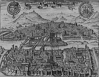
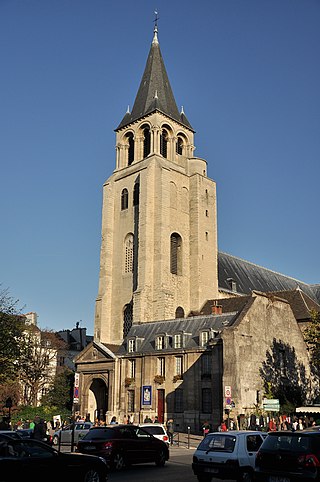
In the 10th century Paris was a provincial cathedral city of little political or economic significance, but under the kings of the Capetian dynasty who ruled France between 987 and 1328, it developed into an important commercial and religious center and the seat of the royal administration of the country. The Île de la Cité became the site of the royal palace and the new cathedral of Notre-Dame, begun in 1163. The Left Bank was occupied by important monasteries, including the Abbey of Saint-Germain-des-Prés and the Abbey of St Genevieve. In the late 1100s, the collection of colleges on the left bank became one of the leading universities in Europe. The Right Bank, where the ports, central markets, artisans and merchants were located, became the commercial center of the city, and the merchants assumed an important role in running the city. Paris became a center for the creation of illuminated manuscripts and the birthplace of Gothic architecture. Despite civil wars, the plague, and foreign occupation, Paris became the most populous city in the Western world during the Middle Ages.
The Ramparts of Senlis are located in Senlis (Oise), capital of the Oise arrondissement in France. They consist of the Gallo-Roman city walls and medieval ramparts proper.
The tour du coin was one of the corner towers of the ancient wall of Philip II Augustus in Paris, built between 1190 and 1209.
In French, a Tournelle may refer to :

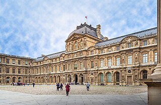
The Cour Carrée is one of the main courtyards of the Louvre Palace in Paris. The wings surrounding it were built gradually, as the walls of the medieval Louvre were progressively demolished in favour of a Renaissance palace.
The Louvre Castle, also referred to as the Medieval Louvre, was a castle begun by Philip II of France on the right bank of the Seine, to reinforce the city wall he had built around Paris. Over time it was expanded but was generally demolished above ground in stages between 1528 and 1660 to make way for expanding the Louvre Palace, while some parts of the castle's foundations were incorporated in construction of the later palace.

The following outline is provided as an overview of and topical guide to Paris:
| Authority control databases: Geographic |
|---|