
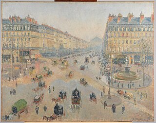
The 2nd arrondissement of Paris is one of the 20 arrondissements of the capital city of France. In spoken French, this arrondissement is colloquially referred to as deuxième. It is governed locally together with the 1st, 3rd and 4th arrondissement, with which it forms the 1st sector of Paris.

Saint-Jacques is a station on Line 6 of the Paris Métro. It serves Place Saint-Jacques in the 14th arrondissement. The Boulevard Saint-Jacques and Rue du Faubourg-Saint-Jacques also intersect the square. It is one of only a few Métro stations that have a combined entrance and ticket hall at street-level.

The Boulevard Saint-Germain is a major street in Paris on the Rive Gauche of the Seine.

Wallace fountains are public drinking fountains named after, financed by and roughly designed by Sir Richard Wallace. The final design and sculpture is by Wallace's friend Charles-Auguste Lebourg. They are large cast-iron sculptures scattered throughout the city of Paris, France, mainly along the most-frequented sidewalks. A great aesthetic success, they are recognized worldwide as one of the symbols of Paris. A Wallace fountain can be seen outside the Wallace Collection in London, the gallery that houses the works of art collected by Sir Richard Wallace and the first four Marquesses of Hertford.

The Boulevard Saint-Michel is one of the two major streets in the Latin Quarter of Paris, France, the other being the Boulevard Saint-Germain. It is a tree-lined boulevard which runs south from the Pont Saint-Michel on the Seine and Place Saint-Michel, crosses the Boulevard Saint-Germain and continues alongside the Sorbonne and the Jardin du Luxembourg, ending at the Place Camille Jullian just before the Port-Royal RER station and the Avenue de l'Observatoire. It was created by Baron Haussmann to run parallel to the Rue Saint-Jacques which marks the historical north-south axis of Paris. It is known colloquially as Boul'Mich' in French.
Haussmann's renovation of Paris was a vast public works programme commissioned by French Emperor Napoleon III and directed by his prefect of the Seine, Georges-Eugène Haussmann, between 1853 and 1870. It included the demolition of medieval neighbourhoods that were deemed overcrowded and unhealthy by officials at the time, the building of wide avenues, new parks and squares, the annexation of the suburbs surrounding Paris, and the construction of new sewers, fountains and aqueducts. Haussmann's work was met with fierce opposition, and he was dismissed by Napoleon III in 1870. Work on his projects continued until 1927. The street plan and distinctive appearance of the centre of Paris today are largely the result of Haussmann's renovation.

Rue du Bac is a street in Paris situated in the 7th arrondissement. The street, which is 1150 m long, begins at the junction of the quais Voltaire and Anatole-France and ends at the rue de Sèvres.

Saint-Lazare Prison was a prison in the 10th arrondissement of Paris, France. It existed from 1793 until 1935 and was housed in a former motherhouse of the Vincentians.

The Rue du Faubourg-Saint-Denis is a street in the 10th arrondissement of Paris. It crosses the arrondissement from north to south, linking the Porte Saint-Denis to La Chapelle Métro station and passing the Gare du Nord.

The city walls of Paris refers to the city walls that surrounded Paris, as it grew from ancient times until the 20th century, built primarily to defend the city but also for administrative reasons. Several successive city walls were built over the centuries, either adding to existing walls or replacing demolished ones, through 1846, when construction of the Thiers wall was completed.
The Rue Rambuteau is a street in central Paris, France, named after the Count de Rambuteau who started the widening of the road prior to Haussmann's renovation of Paris. The philosopher Henri Lefebvre lived on the street and observed from his window the rhythms of everyday life at the intersection located behind the Centre Georges Pompidou.
This article presents the main landmarks in the city of Paris within administrative limits, divided by its 20 arrondissements. Landmarks located in the suburbs of Paris, outside of its administrative limits, while within the metropolitan area are not included in this article.
The Barrière d'Enfer is a pair of tollhouses in Paris that once served as a gate through the Wall of the Farmers-General at the current location of the Place Denfert-Rochereau.
The Faubourg Saint-Antoine was one of the traditional suburbs of Paris, France. It grew up to the east of the Bastille around the abbey of Saint-Antoine-des-Champs, and ran along the Rue du Faubourg Saint-Antoine.

The Rue Mondétour is a small pedestrian street in the 1st arrondissement of Paris.
Prostitution in Paris, both in street form and in dedicated facilities has had a long history and remains present to this day.
La Chapelle is a former commune of the Seine department, which existed from 1790 to 1860 before being incorporated into Paris. It was called "La Chapelle-Franciade" during the French Revolution. It is sometimes called "La Chapelle-Saint-Denis" or "La Chapelle-Sainte-Geneviève".

