
Soconusco is a region in the southwest corner of the state of Chiapas in Mexico along its border with Guatemala. It is a narrow strip of land wedged between the Sierra Madre de Chiapas mountains and the Pacific Ocean. It is the southernmost part of the Chiapas coast extending south from the Ulapa River to the Suchiate River, distinguished by its history and economic production. Abundant moisture and volcanic soil has always made it rich for agriculture, contributing to the flowering of the Mokaya and Olmec cultures, which were based on Theobroma cacao and rubber of Castilla elastica.
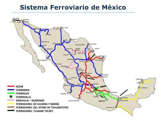
Mexico has a freight railway system owned by the national government and operated by various entities under concessions (charters) granted by the national government. The railway system provides freight and passenger service throughout the country, connecting major industrial centers with ports and with rail connections at the United States border. Passenger rail services were limited to a number of tourist trains between 1997, when Ferrocarriles Nacionales de México suspended service, and 2008, when Ferrocarril Suburbano de la Zona Metropolitana de México inaugurated Mexico's first commuter rail service between Mexico City and the State of Mexico. This is not including the Mexico City Metro, which started service in 1969.
The Ferrocarril del Istmo de Tehuantepec(Ferrocarril del Istmo de Tehuantepec, S.A. de C.V.), also known as Tren Interoceánico, Line Z, Ferrocarril Transístmico or simply Ferroistmo, is part of the Interoceanic Corridor of the Isthmus of Tehuantepec, owned by the Mexican government, that crosses the Isthmus of Tehuantepec between Puerto Mexico, Veracruz, and Salina Cruz, Oaxaca. It is leased to Ferrocarril del Sureste FERROSUR.

The Suchiate River is a river that marks the southwesternmost part of the border between Mexico and Guatemala. From its sources on the southern slopes of the Tacaná volcano in the Sierra Madre range of Guatemala, the 161 km long river flows in a south-southwesterly direction to the border with Mexico at Unión Juárez, past the border towns Talismán and El Carmen, and then Ciudad Tecún Umán and Ciudad Hidalgo (Chiapas) further downstream, where the Puente Rodolfo Robles and a railway bridge cross the river, and on to the Pacific Ocean. Its name comes from the Nahuatl name Xochiatl meaning "flower-water".

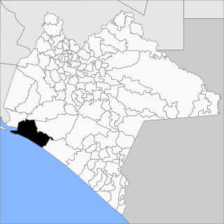
Suchiate is a municipality in the Mexican state of Chiapas, on the border with Guatemala. It is in the Soconusco region, and is the southernmost municipality both in Chiapas and in all of Mexico. On the eastern edge of the municipality, flowing from north to south, is the Río Suchiate, which forms the international border. Two communities within the municipality are border crossings with Guatemala, Ciudad Hidalgo and Talismán. Ciudad Hidalgo is the municipal seat and has a customs house at the border. Suchiate reported a 2010 census population of 35,056 persons. It has a land area of 606.1 km2 (234.0 sq mi).

Macuspana is a city in Macuspana Municipality in the south-central part of the state of Tabasco in southeastern Mexico. The city of Macuspana had a 2005 census population of 30,661 and is the fifth-largest city in the state. It is the municipal seat of the municipality of Macuspana, which has an area of 2,551.7 km2 and a population of 142,954, which includes numerous smaller communities. The largest of these communities is Benito Juárez.

The Port Chiapas or Puerto Madero is a port in Puerto de San Benito in the Tapachula municipality of the Soconusco region in the southern portion of the Mexican state of Chiapas. The port entrance lies about 13 kilometres (8.1 mi) northwest of the mouth of the Suchiate River which is the international boundary between Mexico and Guatemala. Puerto de San Benito is connected by Highway 225 to Tapachula International Airport and the city of Tapachula. Since its opening in 1975 the port has been a small fishing and agricultural transport center. Upgrades carried out in 2005 and since by the government have added facilities for cruise ships and more heavy cargo. Governor Pablo Salazar Mendiguchía had put interest in the original rustic and old port, and later Governor Juan Sabines Guerrero has ordered development of the true port in the hopes it will attract business to Chiapas, the poorest state in Mexico. Ships of the Holland America Line, Regent Seven Seas Cruises, Norwegian Cruise Line, Oceania Cruises and Princess Cruise Line stop at Port Chiapas.

Ayutla is a municipality in the San Marcos Department of Guatemala. It is situated along the Suchiate River natural border with Mexico in the southern part of the department. The municipality center is Ciudad Tecún Umán. There is a combined road and rail bridge known as Puente Rodolfo Robles linking Ayutla to Ciudad Hidalgo in Chiapas, Mexico.

Acapetahua is a town and municipality in the Mexican state of Chiapas, in southern Mexico. As of 2010, the municipality had a total population of 27,580, up from 14,189 in 2005.

Arriaga Municipality is a municipality in the Mexican state of Chiapas, in southern Mexico. It covers an area of 653.3 km2 (252.2 sq mi) and is bordered by the Pacific Ocean and the neighbouring state of Oaxaca, as well as by the Chiapas municipalities of Cintalapa, Jiquipilas, Villaflores and Tonalá.
Tonalá is a municipality in the state of Chiapas in southern Mexico.

The international border between Guatemala and Mexico measures 871 km (541 mi). It runs between north and west Guatemala and the Mexican states of Campeche, Tabasco and Chiapas. The border includes stretches of the Usumacinta River, the Salinas River, and the Suchiate River.
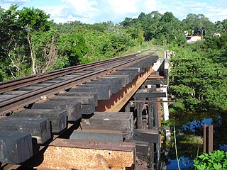
Puente Rodolfo Robles is a bridge across the Suchiate River between Ciudad Hidalgo in the Mexican state of Chiapas and Ciudad Tecún Umán in Guatemala. The bridge is named after Rodolfo Robles, the Guatemalan physician who first described "Robles disease" (Onchocerciasis). The bridge that is used for road traffic as well as restored rail traffic.

Teapa Municipality is a municipality in the Mexican state of Tabasco in south-eastern Mexico.
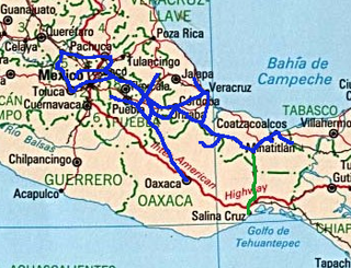
The Coatzacoalcos–Palenque Line, also known as the FA Line, is a railroad owned by the Mexican government, connecting Coatzacoalcos, Veracruz, and Palenque, Chiapas. It was leased to the Ferrocarriles Chiapas-Mayab company.
Line K, also known as the Ixtepec–Ciudad Hidalgo Line, is a railroad owned by the Mexican government that connects Ixtepec, Oaxaca with Ciudad Hidalgo, Chiapas. It was leased to the Ferrocarril Chiapas-Mayab. President Andrés Manuel López Obrador announced that the Mexican government will rehabilitate the line from Ixtepec, Oaxaca to Ciudad Hidalgo, Chiapas.
Unión Hidalgo is a former and future train station in Unión Hidalgo, Oaxaca.
Reforma is a former and future train station located in Reforma de Pineda, Oaxaca.
Villa Comaltitlán is a former and future railway station in Villa Comaltitlán, Chiapas.

