
Managua is the capital and largest city of Nicaragua, and one of the largest cities in Central America. Located on the shores of Lake Managua, the city had an estimated population of 1,055,247 as of 2020, and a population of 1,401,687 in its metropolitan area. The city also serves as the seat of Managua Department.

Jinotega is a department of Nicaragua. Its departmental head is Jinotega. It is located in the north of the country, on the border with Honduras.

San Rafael del Norte is a municipality and a town in the Jinotega department.
Managua is a department in Nicaragua. It covers an area of 3,465 km2 and has a population of 1,559,774, making it the country's most populated department. The capital is the city of Managua, which is also the capital of Nicaragua. The department has two coastlines, on the Pacific Ocean and on Lake Managua, but does not border Lake Nicaragua. The Nahua chiefdom of Tekwantepet was located in the Managua department. According to Spanish conquistador and historian Gonzalo Fernández de Oviedo y Valdés, Tekwantepet one of the last chiefdoms in present-day Nicaragua to fall to the conquistadors and their central Mexican allies. The chiefdom's name is a combination of the Nawat words tēkwani (jaguar), and tepet (hill), therefore the translation of Tekwantepet is "hill of jaguars" or "jaguar hill". The municipality of Ticuantepe located in the department is likely named after this chiefdom. The Indigenous inhabitants of Managua are the Chorotegas and Nahuas.

Nueva Segovia is a department in Nicaragua. It covers an area of 3,491 km2 and has a population of 275,291. Nueva Segovia is also home to the indigenous Chorotegas and Nahuas. The capital is Ocotal.

Ocotal is the capital of the Nueva Segovia Department in Nicaragua, Central America and the municipal seat of Ocotal Municipality.

Diriamba is a city and a municipality in the Carazo department of Nicaragua, with a population of 65,243. It is located 41 km south of Managua, the capital of Nicaragua.
Dolores is a municipality in the Carazo department of Nicaragua. It is the smallest municipality in Nicaragua, as it consists only of the urban area or dwellings of its head town.
Acoyapa is a town and a municipality in the Chontales Department of Nicaragua. Its name comes from the word "Acoyaph" which means "place from above".
El Crucero is a municipality in the Managua department of Nicaragua.
Mateare is a town and a municipality in the Managua department of Nicaragua. The municipality covers an area of 297 km2 and has an estimated population of 64,732.

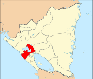
Ticuantepe is a town and a municipality in the Managua department of Nicaragua with an estimated population of 39,012. The municipality is likely named after the Nahua chiefdom of Tekwantepet which was located in the Managua department. According to Spanish conquistador and historian Gonzalo Fernández de Oviedo y Valdés, Tekwantepet was a small but militarily strong chiefdom that was one of the last to fall to the conquistadors and their central Mexican allies. The chiefdom's name is a combination of the Nawat words tēkwani (jaguar), and tepet (hill), therefore the translation of Tekwantepet is "hill of jaguars" or "jaguar hill".

Tipitapa is a city and municipality in the Managua department of western Nicaragua. The area is located between Lake Managua and Lake Nicaragua.
San Fernando is a municipality in the Nueva Segovia Department of Nicaragua.
Quilalí is a town and a municipality in the Nueva Segovia Department of Nicaragua.

The United States occupation of Nicaragua from August 4, 1912, to January 2, 1933, was part of the Banana Wars, when the U.S. military invaded various Latin American countries from 1898 to 1934. The formal occupation began on August 4, 1912, even though there were various other assaults by the United States in Nicaragua throughout this period. American military interventions in Nicaragua were designed to stop any nation other than the United States of America from building a Nicaraguan Canal.

Masaya is the capital city of Masaya Department in Nicaragua. It is situated approximately 14 km west of Granada and 31 km southeast of Managua. It is located just east of the Masaya Volcano, an active volcano from which the city takes its name. With an estimated population of 138,657 (2022), it is Nicaragua's fourth most populous city, and is culturally known as the City of Flowers.
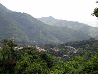
Chocoyero-El Brujo Natural Reserve is located in the municipality of Ticuantepe in the Managua department of Nicaragua. Chocoyero-El Brujo is one of 78 protected areas in Nicaragua, and at just 455 acres (1.8 km2) this tropical forest is one of the smallest in size. Chocoyero-El Brujo was declared a natural reserve in 1993 is managed by the Ministry of the Environment and Natural Resources (MARENA).
The following is an alphabetical list of topics related to Nicaragua.

The Battle of Ocotal occurred in July 1927, during the American occupation of Nicaragua. A large force of rebels loyal to Augusto César Sandino attacked the garrison of Ocotal, which was held by a small group of US Marines and Nicaraguan National Guards. Ultimately the rebels were defeated with heavy losses, while the Americans and their Nicaraguan allies suffered very light casualties.

