Managua is the capital and largest city of Nicaragua, and one of the largest cities in Central America. Located on the shores of Lake Managua, the city had an estimated population of 1,055,247 as of 2020, and a population of 1,401,687 in its metropolitan area. The city also serves as the seat of Managua Department.

Granada is a city in western Nicaragua and the capital of the Granada Department. With an estimated population of 105,862 (2022), it is Nicaragua's ninth most populous city. Granada is historically one of Nicaragua's most important cities, economically and politically. It has a rich colonial heritage, seen in its architecture and structure.
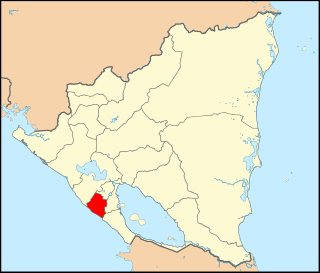
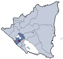
Carazo is a department in Nicaragua. It covers an area of 1,081 km2 and has a population of 198,395. The capital is Jinotepe.

Jinotega is a department of Nicaragua. Its departmental head is Jinotega. It is located in the north of the country, on the border with Honduras.

San Rafael del Norte is a municipality and a town in the Jinotega department.

Masaya is a department in Nicaragua. It is the country's smallest department by area (611 km2) and has a population of 397,632. The capital is the city of Masaya. It is famous among Nicaraguan people for its nickname, "La Cuna Del Folklore" which translates to. It is also the site of the Masaya Volcano, an active 635m volcano which last erupted in 2016.

Estelí, officially Villa de San Antonio de Pavia de Estelí is a city and municipality within the Estelí department. It is the 8th largest city in Nicaragua due to the high urbanization of its municipality, at 84.8%, with an urban population of 111,244. It is also the 8th largest municipality, and an active commercial center in the north, known as "the Diamond of the Segovia" and the de facto capital of the north.

Diriamba is a city and a municipality in the Carazo department of Nicaragua, with a population of 65,243. It is located 41 km south of Managua, the capital of Nicaragua.

Juigalpa is the municipal seat of Juigalpa Municipality and the capital city of the Chontales Department of Nicaragua. It is located within the municipality of Juigalpa, approximately 140 km east of Managua on Carretera Rama, in the central region of Nicaragua.

Tipitapa is a city and municipality in the Managua department of western Nicaragua. The area is located between Lake Managua and Lake Nicaragua.
Masatepe Masatepe is one of the nine municipalities of the Department of Masaya in Nicaragua. It is located on the plateau of the villages 50 kilometers from Managua along the road to Masaya. It belongs to the tourist corridor of " Los Pueblos Blancos" on top of the coffee-producing Volcanic Plateau. The origin of the word "Masatepe" comes from Nahuatl Mazatl-tepec, «populated deer» or mazatl-tepetl, 'Deer Mountain'.

According to 2007 statistics released by the U.S. Department of State concerning Islam in Nicaragua, there are approximately 1,200 to 1,500 Muslims, mostly Sunnis who are resident aliens or naturalized citizens from Palestine, Libya, and Iran or natural-born Nicaraguan citizens born to both of the two groups. The Islamic Cultural Center in Managua serves as the primary salaat (prayer) center for Muslims in the city, with approximately 320 men attending on a regular basis. Muslims from Granada, Masaya, Leon, and Chinandega also travel to the Managua center for Friday prayers. Granada, Masaya, and Leon have smaller prayer centers in the homes of prominent local Muslims. In May 2007 the Sunni leader of the Managua prayer center was dismissed, due to the increase in Iranian influence in the Muslim community and was to be replaced by a Shi'a religious leader. By the end of the reporting period the Shi'a leader had not been identified.

Masaya is the capital city of Masaya Department in Nicaragua. It is situated approximately 14 km west of Granada and 31 km southeast of Managua. It is located just east of the Masaya Volcano, an active volcano from which the city takes its name. With an estimated population of 138,657 (2022), it is Nicaragua's fourth most populous city, and is culturally known as the City of Flowers.

Apoyeque is a pyroclastic shield, located in the Chiltepe Peninsula Natural Reserve in Nicaragua. It has a 2.8-km wide, 400-m-deep, lake-filled caldera.
The Miss Nicaragua is an American beauty pageant that has been held annually since 1955 to select the entrant from Nicaragua in the Miss Universe and since 2023 to select the entrant to Miss Charm International pageant. Until 2001 when the model agency Siluetas announces that the most important beauty pageant in the country will be operated by Karen Celebertti.

Tourism in Nicaragua has grown considerably recently, and it is now the second largest industry in the nation. Nicaraguan President Daniel Ortega has stated his intention to use tourism to combat poverty throughout the country.

Chocoyero-El Brujo Natural Reserve is located in the municipality of Ticuantepe in the Managua department of Nicaragua. Chocoyero-El Brujo is one of 78 protected areas in Nicaragua, and at just 455 acres (1.8 km2) this tropical forest is one of the smallest in size. Chocoyero-El Brujo was declared a natural reserve in 1993 is managed by the Ministry of the Environment and Natural Resources (MARENA).
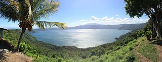
Laguna de Apoyo Nature Reserve is a nature reserve located between the departments of Masaya and Granada in Nicaragua. Lake Apoyo was declared a nature reserve in 1991 and is managed by the Ministry of the Environment and Natural Resources (MARENA) and comprises one of 78 protected areas of Nicaragua. Activities within the Laguna de Apoyo Nature Reserve are regulated by its management plan, approved in 2010, which prohibits the construction of housing within the reserve and use of motorized vehicles on the lake. Geological data suggests that Lake Apoyo originated about 23,000 years ago.
The following is a timeline of the history of the city of Managua, Nicaragua.