
Chester is a census-designated place (CDP) in Chesterfield County, Virginia, United States. The population was 20,987 at the 2010 census.
Tappahannock is the oldest town in Essex County, Virginia, United States. The population was 2,375 at the 2010 census, up from 2,068 at the 2000 census. Located on the Rappahannock River, Tappahannock is the county seat of Essex County. Its name comes from an Algonquian language word lappihanne, meaning "Town on the rise and fall of water" or "where the tide ebbs and flows." In 1608 John Smith landed in Tappahannock and fought with the local Rappahannock tribe. After defeating them, he later made peace.

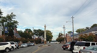
Irvington is a town in Lancaster County, Virginia, United States. The population was 673 at the 2000 census and it is located on a peninsula of land known as the Northern Neck. It has been designated a historic district.
Hampton Veterans Affairs National Cemetery is a United States National Cemetery located the city of Hampton, Virginia. It encompasses only 0.3 of an acre, and has 22 interments. It is currently closed to new interments.
Baywood is an unincorporated community in Grayson County, in the southwestern part of the U.S. state of Virginia.

Young is an unincorporated community in Brown Township, Morgan County, in the U.S. state of Indiana.
Dragon Run State Forest is a Virginia state forest located in King and Queen County. 1,811 acres (7.33 km2) in size, it protects the Dragon Run Swamp while allowing for forest management. Hunting is permitted on the forest grounds.
Sandy Point State Forest is a state forest located in King William County, Virginia. 2,043 acres (8.27 km2) in size, it is characterized by its concentration of water-based resources, and recreational activities are allowed on the property, as are hunting and fishing..
Deep Hole is an unincorporated community in Accomack County, Virginia, United States.
Locust Mount is an unincorporated community in Accomack County, Virginia.
Virginia Motor Speedway is a 1⁄2-mile (0.80 km) semi-banked dirt oval raceway located in Jamaica, Virginia. VMS features a clay racing surface with 14 degree banking in both corners and 4 degrees on the front and back stretch. Races are held on Saturday nights and are sanctioned by the American Speed Association. Regular events include Steel Block Late Models, Modifieds, Sportsman, and Limited Stock. VMS has a seating capacity of 8,000 in the main grandstands.

Melsons Corner is an unincorporated community in El Dorado County, California. It is located 4 miles (6.4 km) east-northeast of Aukum, at an elevation of 2087 feet.

The Yorktown Formation is a mapped bedrock unit in the Coastal Plain of Maryland, Virginia, North Carolina and South Carolina. It is overconsolidated and highly fossiliferous.
Lara is an unincorporated community in Northumberland and Richmond counties, in the U.S. state of Virginia.
Farnham is an unincorporated community in Richmond County, in the U.S. state of Virginia.
Simonson is an unincorporated community in Richmond County, in the U.S. state of Virginia.
Liberty is an unincorporated community in Caroline County, in the U.S. state of Virginia.
Clay Bank is an unincorporated community in Gloucester County, in the U. S. state of Virginia.
Hermitage Banks is an unincorporated community in Gloucester County, in the U. S. state of Virginia.
Huron is an unincorporated community in Polk County, in the U.S. state of Missouri.


