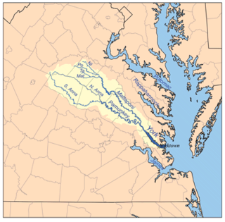
The Virginia Peninsula is a peninsula in southeast Virginia, USA, bounded by the York River, James River, Hampton Roads and Chesapeake Bay. It is sometimes known as the Lower Peninsula to distinguish it from two other peninsulas to the north, the Middle Peninsula and the Northern Neck.

The Middle Peninsula is the second of three large peninsulas on the western shore of Chesapeake Bay in Virginia, in the United States. It lies between the Northern Neck and the Virginia Peninsula. This peninsula is bounded by the Rappahannock River on the north and the York River on the south, with the Chesapeake Bay to the east. It encompasses six Virginia counties: Essex, Gloucester, King and Queen, King William, Mathews, and Middlesex. Developed for tobacco plantations in the colonial era, in the 21st century the Middle Peninsula is known for its quiet rural life, vegetable truck-farming, and fishing industry.

The York River is a navigable estuary, approximately 34 miles (55 km) long, in eastern Virginia in the United States. It ranges in width from 1 mile (1.6 km) at its head to 2.5 miles (4.0 km) near its mouth on the west side of Chesapeake Bay. Its watershed drains an area of the coastal plain of Virginia north and east of Richmond.
Magruder was a small unincorporated town in Virginia near Williamsburg in York County. Settled mostly by African-American freedmen after the American Civil War, it once had its own church, post office, cemetery, lodge, and homes. After this land was acquired for the development of the US military reservation known as Camp Peary, all the residents and businesses were displaced. Magruder is considered extinct and one of the lost towns of Virginia.
Bigler's Mill was a small town in Virginia near Williamsburg in York County which is now extinct. It is considered one of the many lost towns of Virginia. The original community on this site was founded by James Bigler in the spring of 1852, who purchased 2400 acres of timberland, part of the tract known as Rippon Hall. He built a sawmill and gristmill with a long pier extending into the York River. A series of homes, a store and church were also constructed. During the Peninsula Campaign of the Civil War, the property was occupied by Confederate forces; in May of 1862, Federal gunboats shelled the mill and set fire to the buildings and the pier, for which Bigler was later compensated.
Tabb is an unincorporated community in York County, Virginia, United States, on the Virginia Peninsula. Major roads include U.S. Route 17 and State Route 134.

The Pamunkey River is a tributary of the York River, about 93 miles (150 km) long, in eastern Virginia in the United States. Via the York River it is part of the watershed of Chesapeake Bay.
The Warwick River is a 14.4-mile-long (23.2 km) tidal estuary which empties into the James River a few miles from Hampton Roads at the southern end of Chesapeake Bay in southeast Virginia in the United States. Originating in York County near the northern side a few miles west of Yorktown, it flows south across the Virginia Peninsula and is almost entirely located in the independent city of Newport News.
The Coan River is a 7.5-mile-long (12.1 km) river in Virginia's Northern Neck region. It is a tributary of the Potomac River. It flows from its source in Heathsville through Northumberland County and into the Potomac between Lewisetta and Walnut Point.
Barhamsville is an unincorporated community in New Kent County, Virginia, United States. It is home to a monastery of the Poor Clares.
The Perrin River is a 1.3-mile-long (2.1 km) tidal river in the U.S. state of Virginia. It is a small inlet on the north shore of the York River near that river's mouth at Chesapeake Bay.
The Poropotank River is a 16.0-mile-long (25.7 km) river in the U.S. state of Virginia. It is a tributary of the York River and forms part of the boundary between King and Queen and Gloucester counties.

The Yorktown Formation is a mapped bedrock unit in the Coastal Plain of Maryland, Virginia, North Carolina and South Carolina. It is overconsolidated and highly fossiliferous.

Fleeton is an unincorporated community in Northumberland County, in the U.S. state of Virginia. It is located at the mouth of the Great Wicomico River.
Farnham is an unincorporated community in Richmond County, in the U.S. state of Virginia.
Oakley Landing is an unincorporated community in Richmond County, in the U.S. state of Virginia. It is located eight miles south of Farnham at the southern tip of Hales Point, close to Tarpley Point, on the Rappahannock river.
York River Pines is an unincorporated community in Gloucester County, in the U. S. state of Virginia.
York View is an unincorporated community in Gloucester County, Virginia, United States.
Bullard Creek is a stream in Goodhue County, in the U.S. state of Minnesota.
Cave Spring Branch is a stream in eastern Dade County in southwest Missouri.


