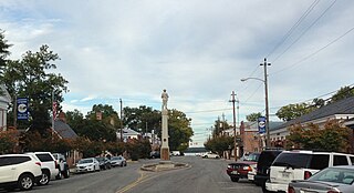
Tappahannock is the oldest town in Essex County, Virginia, United States. The population was 2,375 at the 2010 census, up from 2,068 at the 2000 census. Located on the Rappahannock River, Tappahannock is the county seat of Essex County. Its name comes from an Algonquian language word lappihanne, meaning "Town on the rise and fall of water" or "where the tide ebbs and flows." In 1608 John Smith landed in Tappahannock and fought with the local Rappahannock tribe. After defeating them, he later made peace.
Gloucester Courthouse is a census-designated place (CDP) in and the county seat of Gloucester County, Virginia, United States. The population was 2,951 at the 2010 census.

Cape Charles is a town / municipal corporation in Northampton County, Virginia, United States. The population was 1,009 as of the 2010 U.S.Decennial Census.

Deltaville is a small unincorporated community and census-designated places on the eastern tip of Middlesex County in the eastern part of the U.S. state of Virginia. It is known for being a vacation spot for those looking for sailing, fishing, and other activities associated with the water. The Middlesex County Board of Supervisors approved a resolution on October 2, 2012 supporting the efforts of the official naming, " Deltaville, The Boating Capital of the Chesapeake Bay." Approximately 500-800 full-time residents call Deltaville home; however, the town's population swells to several thousand in the summer months. Deltaville is also home to numerous retirees. The Census Bureau defines Deltaville as a census-designated place (CDP) with a population of 1,119 as of 2010. The town developed around being a large boat building area, mostly for commercial bay watermen. However those days have passed and now the area is dotted with numerous marinas, boatyards, and marine related businesses.

North Star is an unincorporated community in Yuba County, California. It is located 2 miles (3.2 km) northeast of Strawberry Valley, at an elevation of 4019 feet.
Hall Station is an unincorporated community in Alameda County, California. It is located on the Southern Pacific Railroad 4 miles (6.4 km) north-northwest of downtown Newark at an elevation of 16 feet.
Lara is an unincorporated community in Northumberland and Richmond counties, in the U.S. state of Virginia.
Luttrellville is an unincorporated community in Northumberland and Richmond counties, in the U.S. state of Virginia.
Mila is an unincorporated community in Northumberland County, in the U.S. state of Virginia. Mila is located at 37°50′32″N76°19′39″W.
Rainswood is an unincorporated community in Northumberland and Richmond counties, in the U.S. state of Virginia.
Walkers Corner is an unincorporated community in Northumberland and Richmond counties, in the U.S. state of Virginia.

Callands is an unincorporated community in Pittsylvania County, in the U.S. state of Virginia. It was named after Samuel Calland, a native of Scotland that immigrated during the 18th century, whose general store became a popular fixture of the community. The area around the store served as the county seat of Pittsylvania County until the end of 1776.
Winter Harbor Haven is an unincorporated community in Mathews County, in the U. S. state of Virginia.
Capahosic is an unincorporated community in Gloucester County, in the U. S. state of Virginia.
Harbor Hills is an unincorporated community in Gloucester County, in the U. S. state of Virginia.
Owl Trap is an unincorporated community in Gloucester County, in the U. S. state of Virginia.
Rosewell is an unincorporated community in Gloucester County, in the U. S. state of Virginia, site of the Rosewell Plantation.
Risner is an unincorporated community in Floyd County, in the U.S. state of Kentucky.
Whites is an unincorporated community in Grays Harbor County, in the U.S. state of Washington.
Hurry is an unincorporated community in St. Mary's County, Maryland.


