
Lancaster County is a county located on the Northern Neck in the Commonwealth of Virginia. As of the 2010 census, the population was 11,391. Its county seat is Lancaster.

Irvington is a town in Lancaster County, Virginia, United States. The population was 673 at the 2000 census and it is located on a peninsula of land known as the Northern Neck. It has been designated a historic district.

Urbanna is a town in Middlesex County, Virginia, United States. Urbanna means “City of Anne” and was named in honor of England's Queen Anne. The population was 476 at the 2010 census.

Dungannon is a town in Scott County, Virginia, United States. The population was 332 at the 2010 census. It was named after the town of Dungannon in County Tyrone, Northern Ireland.

The Rappahannock River is a river in eastern Virginia, in the United States, approximately 195 miles (314 km) in length. It traverses the entire northern part of the state, from the Blue Ridge Mountains in the west where it rises, across the Piedmont to the Fall Line, and onward through the coastal plain to flow into the Chesapeake Bay, south of the Potomac River.
Bigler's Mill was a small town in Virginia near Williamsburg in York County which is now extinct. It is considered one of the many lost towns of Virginia. The original community on this site was founded by James Bigler in the spring of 1852, who purchased 2400 acres of timberland, part of the tract known as Rippon Hall. He built a sawmill and gristmill with a long pier extending into the York River. A series of homes, a store and church were also constructed. During the Peninsula Campaign of the Civil War, the property was occupied by Confederate forces; in May of 1862, Federal gunboats shelled the mill and set fire to the buildings and the pier, for which Bigler was later compensated.
The Yeocomico River is a 1.1-mile-long (1.8 km) tidal tributary of the southern portion of the Potomac River in Virginia's Northern Neck. The Yeocomico forms the boundary between Westmoreland and Northumberland counties. Yeocomico is a Native American name roughly translated as "tossed to and fro by the waters." Others suggest it is an Algonquian word that means "four dwelling places" since the river has a branch on either side with each dividing into two large forks.
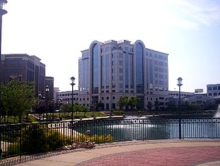
City Center at Oyster Point is a business district in the Oyster Point section of Newport News, Virginia. It is a 52-acre (210,000 m2) high density mixed-use development that has 230,000 sq ft (21,000 m2). of Retail Shops and Restaurants and 1,000,000 sq ft (100,000 m2). of Class A office space. It is inspired by the maritime history of the city, landscaped in a southern living style with views to a 5-acre (20,000 m2) fountain.
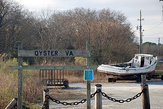
Oyster is a small unincorporated community on the Atlantic Coast of the Eastern Shore of the U.S. state of Virginia in Northampton County. It is at an elevation of 3 feet above sea level.
Midway is an unincorporated community in Mecklenburg County, Virginia. It lies at an elevation of 371 feet.
The Chesapeake Bay National Estuarine Research Reserve contains a diverse collection of habitats including oyster reefs, seagrass beds, tidal wetlands, sandy shoals and mudflats. In order to address the diversity of habitats, the Chesapeake Bay-Virginia Reserve established a multi-site system from tidal freshwater to high salinity conditions along the York River estuary. Reserve components include Sweet Hall Marsh, Taskinas Creek, Catlett Island and Goodwin Islands.

The Yorktown Formation is a mapped bedrock unit in the Coastal Plain of Maryland, Virginia, North Carolina and South Carolina. It is overconsolidated and highly fossiliferous.
Lara is an unincorporated community in Northumberland and Richmond counties, in the U.S. state of Virginia.
Luttrellville is an unincorporated community in Northumberland and Richmond counties, in the U.S. state of Virginia.
Mila is an unincorporated community in Northumberland County, in the U.S. state of Virginia. Mila is located at 37°50′32″N76°19′39″W.
Rainswood is an unincorporated community in Northumberland and Richmond counties, in the U.S. state of Virginia.
Carters Cove is an unincorporated community in Gloucester County, in the U. S. state of Virginia. To the inhabitants of Carters Cove it is known as "The Cove" or just "Cove".
Creekwood Cove Estates is an unincorporated community in Gloucester County, in the U. S. state of Virginia.
Quiet Cove is an unincorporated community in Gloucester County, in the U. S. state of Virginia.
Marcoot is an extinct town in Reynolds County, in the U.S. state of Missouri. The GNIS classifies it as a populated place.


