
The Salt River is a river in Gila and Maricopa counties in Arizona, United States, that is the largest tributary of the Gila River. The river is about 200 miles (320 km) long. Its drainage basin is about 13,700 square miles (35,000 km2) large. The longest of the Salt River's many tributaries is the 195-mile (314 km) Verde River. The Salt's headwaters tributaries, the Black River and East Fork, increase the river's total length to about 300 miles (480 km). The name Salt River comes from the fact that the river flows over large salt deposits shortly after the merging of the White and Black Rivers.

Lynx Lake, Arizona, is a 55-acre (220,000 m2) reservoir located within Prescott National Forest, approximately 5 miles (8.0 km) east of Prescott, Arizona, in the Bradshaw Mountains. The lake is located at 5,530 feet (1,690 m) elevation and is stocked for fishing. It is one of the most popular recreation areas in central Arizona. Mild weather, the cool ponderosa pine forest, trout fishing, boating, mountain hiking, horseback riding, archaeological sites, and bird watching attract visitors from throughout Arizona. The lake was formed in 1952, when a dam was put in Lynx Creek, 6 miles (9.7 km) below Walker, Arizona.

Sinnemahoning State Park is a 1,910-acre (773 ha) Pennsylvania state park in Grove Township, Cameron County and Wharton Township, Potter County, Pennsylvania, in the United States. The park is surrounded by Elk State Forest and is mountainous with deep valleys. The park is home to the rarely seen elk and bald eagle. Sinnemahoning State Park is on Pennsylvania Route 872, eight miles (13 km) north of the village of Sinnamahoning. In 1958, the park opened under the direction of the Pennsylvania Bureau of Forestry: it became a Pennsylvania State Park in 1962.

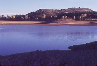
Alamo Lake State Park is a state park of Arizona, USA, centered on Alamo Lake, a flood control and recreational reservoir. The park is located in western Arizona about 38 miles (61 km) north of Wenden. It is accessed via a paved two-lane road off either U.S. Route 60 to the south or U.S. Route 93 to the east. Owing to its remoteness, the park is often considered one of the "best kept secrets" of the state park system.

Marsh Creek State Park is a 1,705 acres (690 ha) Pennsylvania state park in Upper Uwchlan and Wallace Townships, Chester County, Pennsylvania in the United States. The park is the location of the 535-acre (217 ha) man-made Marsh Creek Lake. With an average depth of 40 feet, the lake is stocked with fish and is a stop for migrating waterfowl. Marsh Creek State Park is 2 miles (3.2 km) west of Eagle on Pennsylvania Route 100. Park road hours 8:00 am until sunset. All other access open 24 hours.
Goldwater Lake is a reservoir formed by a dam on Banning Creek, located south of Prescott in North Central Arizona. This lake is maintained by the City of Prescott Parks and Recreation Department. The park has facilities for picnicking, fishing, boating, hiking, volleyball, and horseshoes.

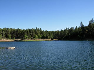
Watson Lake is one of two reservoirs at the Granite Dells, in Prescott, Arizona, that was formed in the early 1900s when the Chino Valley Irrigation District built a dam on Granite Creek. The City of Prescott bought the reservoir and surrounding land in 1997 to preserve it as recreational land. Local rockclimbers use the granite cliffs above and adjacent to the lake for top-roping and lead climbing. The lake is also the home of TriCity Prep Rowing Crew, a local high school team and only rowing team in Northern Arizona.

Chevelon Canyon Lake is a small reservoir located in northern Arizona, about 28 mi (45 km) northwest of the town of Heber. It is one in a series of small, canyon-bound lakes located on the Mogollon Rim, collectively referred to as the Rim Lakes. It is said to be among the most difficult to access in the region. It is also the second reservoir on Chevelon Creek, downstream from Woods Canyon Lake. The facilities are maintained by Apache–Sitgreaves National Forests division of the USDA Forest Service.
Woods Canyon Lake is a small lake located in northern Arizona, United States, about 30 mi (48 km) east of the city of Payson. It is one in a series of small, canyon-bound lakes located on the Mogollon Rim, collectively referred to as the Rim Lakes. It is among the more developed and accessible of the Rim Lakes. It is also the first reservoir on Chevelon Creek, upstream from Chevelon Canyon Lake.
Becker Lake is a reservoir managed as a trophy trout lake. Located near Springerville, Arizona, Becker Lake is part of the 622-acre (252 ha) Becker Lake Wildlife Area. Built around the year 1880, it is one of the oldest reservoirs in the White Mountains. The Arizona Game and Fish Department acquired the lake and property around it in 1973. The lake is located at 6,910 feet (2,110 m).

East Clear Creek is located in the Mogollon Rim area of the state of Arizona. The closest town Winslow is 45 miles (72 km) away.

The East Verde River is a tributary of the Verde River in the U.S. state of Arizona. Beginning on the Mogollon Rim near Washington Park, it flows generally southwest through Gila County and the Tonto National Forest northeast of Phoenix. Near the middle of its course, it passes to within about 5 miles (8 km) of Payson, which is southeast of the river. The East Verde River flows through parts of the Mazatzal Wilderness west of Payson.
The Lyman Reservoir is the largest lake in the region. Lyman Lake State Park, is located in and administered by the Apache-Sitgreaves National Forest, attracts anglers, as well as campers and water skiers year-round.
Nelson Reservoir is a reservoir located in Apache County, Arizona between Springerville and Alpine. The Reservoir is a long and narrow lake which follows the Nutrioso Creek Valley for nearly a mile. Fish that remain in Nelson Reservoir after summer stockings can grow to good size, making it a popular fishing site with local anglers.
Rainbow Lake is a 116-acre manmade lake near the town of Pinetop-Lakeside in southern Navajo County, Arizona, United States. The lake was created in 1903 when Mormon settlers dammed Walnut Creek, a tributary of the Little Colorado River, to impound water for irrigation.
Built in 1928, Scott Reservoir is an irrigation impoundment on Porter Creek near Pinetop-Lakeside, Arizona, USA. The least developed of the "in town" lakes, trees surround Scott Reservoir. It lies just outside the town limits on the Apache-Sitgreaves National Forests.
Fain Lake is a reservoir located near Prescott Valley in Yavapai County, North Central Arizona.

Tonto Creek is a 72.5-mile-long (116.7 km) stream located in the Mogollon Rim area of the state of Arizona on the north edge of the Tonto National Forest. The closest town, Payson, is 18 miles (29 km) away. Tonto Creek is a stream that flows year round, starting just below the Mogollon Rim, at the northern edge of Tonto National Forest. The creek continues its descent through the Hellsgate Wilderness area and eventually into a wide valley in the Sonoran Desert. It continues through the desert and into the Salt River within the north end of Theodore Roosevelt Lake. The facilities are maintained by Tonto National Forest division of the USDA Forest Service.

Patagonia Lake is a man-made reservoir in Santa Cruz County, Arizona, United States, located southwest of the town of Patagonia, Arizona and northeast of Nogales. The lake was created by damming Sonoita Creek, and is a popular area for boating and sport fishing. Facilities are maintained by Arizona State Parks as part of Patagonia Lake State Park.
Lee Valley Lake is Arizona's highest elevation reservoir, situated at 9,420 feet (2,870 m) in the Apache-Sitgreaves National Forests near Mount Baldy. It is located approximately 35 miles from Pinetop-Lakeside, connected by Arizona highways 260 and 273 and forest road 113. Access is restricted in the winter when roads are closed due to snow, generally December to early April.
