Cleeves Cove

Last updated

Cleeves Cove
Blair Cove
Cleevescove3.JPG
An entrance into Cleeves Cove
LocationDalry, North Ayrshire, Scotland
OS grid NS 3717 4745
Coordinates 55°41′29″N4°40′46″W / 55.691472°N 4.679333°W / 55.691472; -4.679333
Length500 feet (150 m)
Elevation190 feet (58 m)
Entrances3
DifficultyEasy
HazardsAccess path
AccessHazardous

Cleeves Cove or Blair Cove [1] is a solutional cave system on the Dusk Water in North Ayrshire, Scotland, close to the town of Dalry.

Contents

Cave system

The Cleeves, or Cleaves Cove (Scots) cave system is situated in the lower beds of Carboniferous limestone. It has a total passage length of around 500 feet (150 m). The caves are now well above the level of the Dusk Water and lie close to Cleeves Farm and Blair Mill on the Blair Estate. Many of the stalactites and stalagmites have been damaged by visitors. The cave has three practical entrances facing onto the Dusk Water.

A number of older books refer to the romantic sylvan dell of Auchenskeigh, now Auchenskeith, derived from Achadh-na-sgitheach - the field of thorns. [2] The calcareous incrustations in these caves were compared with Gothic fretwork. A number of old limestone quarries lie close to the modern day farm of Auchenskeith, but it is likely that Auchenskeigh is a synonym for Cleeves Cove. [3]

History

The word cove in Scots means 'cave'. [4] John Smith published a monograph entitled Cleaves Cove Stalactites and Stalagmites, published by Elliot Stock in which he provided drawings and a detailed description of these structures within the cave system, [5] many of which have been destroyed. The site was previously known as the 'Elfhouse' or 'Elfhame' [6] the locals at that time believed that these magical creatures had made this their abode. [7] Ness [8] calls the site Glen O'Dusk or the Elf-hame, the caves being the Elf-house. [9]

The 1833 plan of the cave system before it was excavated by John Smith Cleevescovecaveplan.jpg
The 1833 plan of the cave system before it was excavated by John Smith
One of the cave system entrances Cleevescoveentrance.JPG
One of the cave system entrances

The cave system was formed in Dusk Glen when the waters of the Dusk (Dubh-Uisge, Gaelic for 'black water') [11] ran through and eroded the limestone, followed by a period when it was relatively dry allowing the stalactites and stalagmites to form and finally a progressive infilling with soil washed in from above, resulting in a partial infilling of the caves and passageways; at this point John Smith obtained permission from Captain Blair, R.N., of Blair House to explore and ultimately remove some 300 tons of material. [12] The cave now lies 40 feet (12 m) above the Dusk Water due to the excavation of the gorge by the river. Near the middle is a spacious chamber, 35 feet (11 m) long by 27 feet (8.2 m) broad and 12 feet (3.7 m) high. The internal surfaces of the chambers and passageways are covered with calcareous incrustations and numerous crevices branch off in all directions. It was regarded in Victorian times as one of the greatest natural curiosities in Ayrshire. [7]

An emerald, bronze finger-ring and two iron spears from John Smith's excavations Cleevescovecaveitems.jpg
An emerald, bronze finger-ring and two iron spears from John Smith's excavations

The fictional Dr Duguid refers to "Smith's Room" in the caves, although he did not know if Smith was a hermit, smuggler or covenanter. The name is a coincidence as the recollections are before John Smith's time. [14]

Excavations

Smith started in January 1883, working at night, with six volunteers, removing and sifting through 300 tons of deposits over a period of six months. He organised a trip on the Clyde as a reward to his helpers. [15] He recorded his work in several journals and books, producing a map and giving names to some of the features and entrances. [16]

During his excavations John Smith unearthed a number of man-made objects such as a flint knife, spindle-whorl, bone spoon, bronze finger-rings, a stag's horn handle, spear heads, parts of a bridle, an iron battle-axe and a cut-glass emerald. Various bones were found, including those of beaver, sheep, hare, rabbit, cat, rat, dog, weasel, pheasant, partridge, duck, goat, ox, pig and goose. The seeds of fourteen species of plants were found, but none were from edible cereals. [5]

Human and animal occupants

Charcoal deposits were found, suggesting that fires had been lit within. The evidence suggests that the caves were used at some point by humans for either temporary shelter, refuge at times of crisis or both. Dobie [7] records that the cave system was used as a refuge for the local Covenanters during the times of their persecution by the government of Charles II (1630–85) and Paterson confirms this, indicating that the Statistical Account of Ayrshire, written by the local ministers, was his source. [6] Cummell records that the Covenanters held Conventicles in the glen. [17]

The cave system has unsurprisingly been the haunt of foxes, bats, cave spiders, moths, and other animals.

Elfhame

Robin Cummell records that the caves were the "Elfhame o'the Blair", and that at Halloween they would come riding out of the caves on horses that were the size of mice, their long yellow hair straming or tied in knots with crimps of gold. Their quaichs were acorn cups and they drank wine beneath the toadstools. Their cloths were green velvet and their arrows were made of moss-reed tipped with flint arrow heads that were dipped in hemlock poison. The bows were made from the rib bones of unbaptised babies who had been secretly buried in the shaws and glens. [18]

Cholera pit

The burial at Cleeves Cove is located within a low stone wall close to the Dusk water, and is said to be that of a member of the family who lived at Cleeves Farm. Tradition has it that "A prediction was uttered many long ages ago, that Cleaves (sic), on three successive occasions, would be the first place in the parish visited by the pestilence. The cholera of 1832 was called the fulfillment of the second visitation: accordingly, many of the older inhabitants talk of one still being in reserve." [19] It is said locally that a group of trees mark one of the cholera pits.

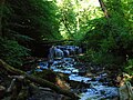
Views of the cave complex

Auchenskeith Quarry

A mineral line ran to this old limestone quarry and its associated limekilns in the mid 19th century.

Covenanters Caves

Several other caves are found in Ayrshire and elsewhere in Scotland that are associated with the Covenanters and the 'Killing Times' of the 17th century, these include Dunton Cove near Airtnoch Farm and Peden's Cave on the River Lugar near Ochiltree.

Related Research Articles

Perceton is a medieval settlement and old country estate in North Ayrshire, Scotland, near the town of Irvine. The ruined church in Perceton is one of the oldest buildings in the Irvine district. The earliest legible gravestone dates from 1698, though older stone coffins will certainly still rest deep within the small hillock on which the chapel and graveyard sit.

<span class="mw-page-title-main">Lugton</span> Human settlement in Scotland

Lugton is a small village or hamlet in East Ayrshire, Scotland with a population of 80 people. The A736 road runs through on its way from Glasgow, 15 miles (24.1 km) to the north, to Irvine in North Ayrshire. Uplawmoor is the first settlement on this 'Lochlibo Road' to the north and Burnhouse is to the south. The settlement lies on the Lugton Water which forms the boundary between East Ayrshire and East Renfrewshire as well as that of the parishes of Dunlop and Beith.

<span class="mw-page-title-main">Kerelaw Castle</span>

Kerelaw Castle is a castle ruin. It is situated on the coast of North Ayrshire, Scotland in the town of Stevenston.

<span class="mw-page-title-main">Hessilhead</span> Area in North Ayrshire, Scotland

Hessilhead is in Beith, North Ayrshire, Scotland. Hessilhead used to be called Hazlehead or Hasslehead. The lands were part of the Lordship of Giffen, and the Barony of Hessilhead, within the Baillerie of Cunninghame and the Parish of Beith. The castle was situated at grid reference NS380532.

<span class="mw-page-title-main">Auchenharvie Castle</span>

Auchenharvie Castle is a ruined castle near Torranyard on the A 736 Glasgow to Irvine road. Burnhouse lies to the north and Irvine to the south. It lies in North Ayrshire, Scotland.

The hamlet of Auchentiber is in North Ayrshire, Parish of Kilwinning, Scotland. Auchentiber is four miles northeast of Kilwinning on the Lochlibo Road, 2+14 mi (3.5 km) from the hamlet of Burnhouse and 2+12 mi (4 km) from the village of Barrmill. Grid Ref. NS3647. Some new housing has been built, but the settlement is still very much a hamlet. The settlement is on the Lugton Water, which runs into the River Garnock after running through Montgreenan and Eglinton Country Park in Irvine.

<span class="mw-page-title-main">Barony and Castle of Giffen</span> Barony in the former District of Cunninghame, now North Ayrshire

The Barony of Giffen and its associated 15th-century castle were in the parish of Beith in the former District of Cunninghame, now North Ayrshire. The site may be spelled Giffen or Giffin and lay within the Lordship of Giffin, which included the Baronies of Giffen, Trearne, Hessilhead, Broadstone, Roughwood and Ramshead; valued at £3,788 9s 10d. The Barony of Giffen comprised a number of properties, including Greenhills, Thirdpart, Drumbuie, Nettlehirst and Balgray, covering about half of the parish of Beith. Giffen was a hundred merk land, separated from the Barony of Beith, a forty-pound land, by the Powgree Burn which rises on Cuff hill. The Lugton Water or the Bungle Burn running through Burnhouse may have been the Giffen barony boundary with that of the adjacent barony and lands of Aiket castle.

<span class="mw-page-title-main">Lugton Water</span> River in Scotland

The Lugton Water, the largest tributary of the River Garnock, runs 14 miles (23 km) from Loch Libo in Uplawmoor, through Lugton and the parishes of Neilston, Beith, Dunlop, Stewarton and Kilwinning. The Lugton joins the Garnock below the tidal limit, shortly after passing through Eglinton Country Park, developed around the ancient estate of the Earl of Eglinton.

Fergushill is a small community in North Ayrshire, Parish of Kilwinning, Scotland. The Barony of Fergushill was held by the Fergushill family of that Ilk and the area has a complex history.

<span class="mw-page-title-main">Caldwell, East Renfrewshire</span> Mansion in East Renfrewshire, Scotland

Caldwell is a mansion and old estate with the remains of a castle nearby. These lands lie close to the Lugton Water and the villages of Uplawmoor in East Renfrewshire and Lugton in East Ayrshire.

<span class="mw-page-title-main">Barbara Gilmour</span>

Barbara Gilmour was a significant figure in 17th century Ayrshire having introduced a method of cheese making which became common throughout Ayrshire and beyond, providing employment and extra income for farmers and others. She lived near Dunlop, a village in East Ayrshire, Scotland, lying between the village of Lugton and the town of Stewarton on the old turnpike road to Glasgow. Cheese made by her method became known as "Dunlop cheese".

<span class="mw-page-title-main">Giffordland</span> Barony in North Ayrshire, United Kingdom

Giffordland is in North Ayrshire, Parish of Dalry (Cunninghame) in the former Region of Strathclyde, Scotland.

<span class="mw-page-title-main">Waterside, East Ayrshire</span> Human settlement in Scotland

Waterside is a village in East Ayrshire, Scotland, situated about five miles north of Galston on the Craufurdland Water in the Parish of Fenwick. It lies a few miles north of Moscow on the A719 and had a population of 141 in the Census of 2001.

<span class="mw-page-title-main">Halket Loch</span> Drained freshwater loch in East Ayrshire, Scotland

Halket Loch' also known as Halkhead or Halketh, was situated in the mid-Ayrshire clayland near Lugton. It is visible as a surface depression in pastureland, sometimes partially flooded, situated in a low-lying area close to farms and dwellings of East, North and Middle Halket and Craighead in the Parish of Dunlop, East Ayrshire, Scotland. The loch was natural, sitting in a hollow created by glaciation. The loch waters drained via the Glazert Water that joins the Annick Water.

Drakemyre or Drakemire was once a distinct village on the Rye Water in North Ayrshire, Parish of Dalry, Scotland. The settlement on the B780 road to Kilbirnie has become incorporated as a suburb within the town of Dalry.

<span class="mw-page-title-main">Bessie Dunlop of Lynn</span> Scottish woman accused of witchcraft

Bessie Dunlop, Elizabeth Dunlop or Elizabeth Jack, was a Scottish farmer's wife from Ayrshire who was burned at the stake at Edinburgh for the crime of sorcery, witchcraft, and incantations. Her case was unusual in the amount of fine detail related in her testimony and the lack of anything but positive or neutral outcomes of her recorded ministrations and actions. Her admission to the use of a familiar spirit and association with the fairies were the main cause of her conviction and her death sentence.

<span class="mw-page-title-main">Soulis Cross</span>

The ancient Soulis Cross was originally located in the centre of Soulis Street (NS43013821) near the Kilmarnock Water in Kilmarnock, East Ayrshire, Scotland. In 1825 a replacement cross in the form of a fluted pillar topped with an urn was erected using funds raised by public inscription and this was placed near the original site but located in an alcove situated within the high boundary wall of the High Kirk (NS43003820). A brass diamond mark was placed in the road to indicate the original site where Lord Soulis is said to have died, but this is no longer visible as it has become covered with tarmac.

<span class="mw-page-title-main">Lands of Templehouse</span> Human settlement in Scotland

The Lands of Templehouse formed a small estate lying between Aiket Castle and the town of Dunlop, East Ayrshire, Parish of Dunlop, Scotland. The laird's house at Templeland of Dunlop Hill, to give it its formal name, stood near to the ancient road leading from Dunlop to Kirkwood and on to Kennox. The lands were held by the Knights Templar until a date prior to 1570 when the Gemmells of Templehouse were granted the property and remained there until 1962, a period of around 500 years. The spelling 'Gemmell' is used for consistency except where otherwise denoted.

The Lands of Dallars or Auchenskeith (NS463337) form a small estate in East Ayrshire, Hurlford, Kilmarnock, Parish of Riccarton, Scotland. The present mansion house is mainly late 18th-century, located within a bend of the Cessnock Water on the site of older building/s. "Dullers or Dillers" was changed to "Auchenskeith" or "Auchinskeigh" (sic) as well as other variants and then the name reverted nearer to the original form as "Dollars" and then finally "Dallars". Dallars lies 3.25 km south of Hurlford.

<span class="mw-page-title-main">Lands of Blacklaw</span> Human settlement in Scotland

The Lands of Blacklaw formed a small property of five merks worth, in the Lordship of Stewarton at the eastern extremity of Strathannick, between the hamlet of Kingsford in East Ayrshire and the East Renfrewshire boundary, Scotland. It was first recorded in 1484 in the Acta Auditorum. Black Law is a prominent whinstone crag lying above Blacklaw Hill Farm.

References

Notes
  1. service, page 194
  2. Dobie, James D. (ed Dobie, J.S.) (1876). Cunninghame, Topographized by Timothy Pont 1604–1608, with continuations and illustrative notices. Pub. Glasgow : John Tweed. p. 49.
  3. Harvey, William (1910), Picturesque Ayrshire. Pub. Dundee : Valentine & sons. p. 90.
  4. Warrack, Alexander (1982). "Chambers Scots Dictionary". Chambers. ISBN   0-550-11801-2.
  5. 1 2 Smith, John (1895). Prehistoric Man in Ayrshire. Pub. Elliot Stock. P. 62–68.
  6. 1 2 Paterson, James (1863-66). History of the Counties of Ayr and Wigton. V. - III - Cunninghame. J. Stillie. Edinburgh. P. 140.
  7. 1 2 3 Dobie, James D. (ed Dobie, J.S.) (1876). Cunninghame, Topographized by Timothy Pont 1604–1608, with continuations and illustrative notices. Pub. John Tweed, Glasgow. P. 125.
  8. Ness, J. A. (1969 - 70). Landmarks of Kilwynnyng. Privately produced. P. 31.
  9. Love, Dane (2009). Legendary Ayrshire. Custom : Folklore : Tradition. Carn Publishing. ISBN   978-0-9518128-6-0. pp. 101 - 102
  10. Dobie, James D. (ed Dobie, J.S.) (1876). Cunninghame, Topographized by Timothy Pont 1604–1608, with continuations and illustrative notices. Pub. John Tweed, Glasgow.
  11. Dobie, James D. (ed Dobie, J.S.) (1876). Cunninghame, Topographized by Timothy Pont 1604–1608, with continuations and illustrative notices. Pub. John Tweed, Glasgow. P. 124.
  12. Smith, John (1895). Prehistoric Man in Ayrshire. Pub. Elliot Stock. P. 62.
  13. Smith, John (1895). Prehistoric Man in Ayrshire. Pub. Elliot Stock. P. 65.
  14. Service, John (Editor) (1887). The Life & Recollections of Doctor Duguid of Kilwinning. Pub. Young J. Pentland. P. 58.
  15. Calder, Page 9
  16. AWAS, Plate 1
  17. Service, Page 56
  18. Service, Page 54
  19. Porterfield, Page 36
Sources