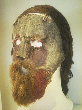
Alexander Peden, also known as "Prophet Peden", was one of the leading figures in the Covenanter movement in Scotland.
Dalry is a small town in the Garnock Valley in Ayrshire, Scotland. Drakemyre is a northern suburb.

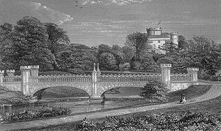
Rowallan Castle is an ancient castle located in Scotland. The castle stands on the banks of the Carmel Water, which may at one time have run much closer to the low eminence upon which the original castle stood, justifying the old name Craig of Rowallan. Elizabeth Mure was mistress and then wife of Robert, High Steward of Scotland, and Guardian of Scotland, who later became King Robert II of Scotland. She may have been born at Rowallan.

Cleeves Cove or Blair Cove is a solutional cave system on the Dusk Water in North Ayrshire, Scotland, close to the town of Dalry.
Old Dailly is a hamlet in South Ayrshire, Scotland. It is located west of Dailly.
Mysterious tunnels or "secret passages" are a common element of the local folklore tradition in Europe. Such tunnels are said to physically link prominent places such as country houses, castles, churches, ancient monuments and other, often medieval, buildings.
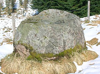
The name gowk stane has been applied to certain standing stones and glacial erratics in Scotland, often found in prominent geographical situations. Other spelling variants, such as gowke, gouk, gouke, goilk, goik, gok, goke, gook are found.

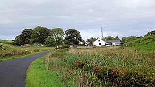
Waterside is a village in East Ayrshire, Scotland, situated about five miles north of Galston on the Craufurdland Water in the Parish of Fenwick. It lies a few miles north of Moscow on the A719 and had a population of 141 in the Census of 2001.
Polkelly Castle, also Pokelly, was an ancient castle located near Fenwick, at NS 4568 4524, in the medieval free Barony of Polkelly, lying north of Kilmarnock, Parish of Fenwick, East Ayrshire, Scotland. The castle is recorded as Powkelly (c1747), Pockelly (c1775), Pow-Kaillie, Ponekell, Polnekel, Pollockelly, Pollockellie, Pokellie, Pothelly, Pathelly Ha' and Polkelly. The name is given circa 1564 as Powkellie when it was held by the Cunninghams of Cunninghamhead.

Bessie Dunlop, Elizabeth Dunlop or Elizabeth Jack, was a Scottish farmer's wife from Ayrshire who was burned at the stake at Edinburgh for the crime of sorcery, witchcraft, and incantations. Her case was unusual in the amount of fine detail related in her testimony and the lack of anything but positive or neutral outcomes of her recorded ministrations and actions. Her admission to the use of a familiar spirit and association with the fairies were the main cause of her conviction and her death sentence.

Wallace's Heel Well or Wallace's Heel is located beside the River Ayr (NS35502122) near the old Holmston lime kiln, Ayr, Scotland. It is a petrosomatoglyph said to represent the imprint of a heel and is associated with the story of an escape from English soldiers made by the Scottish hero William Wallace.

The Lady's Well is a natural spring surmounted by a large cross that stands beside the Stra Burn Ford (NS254630) near Auchmannoch House in the Parish of Sorn, East Ayrshire, Scotland. It is associated with the Virgin Mary as a curative well, a Wishing Well and also a Clootie well, additionally Mary Queen of Scots is said to have once watered her horse here. A large red sandstone cross was erected here at an unrecorded date. The well is also said to have acquired its name through "..one of the ladies of Auchmannoch family drinking water exclusively from here."

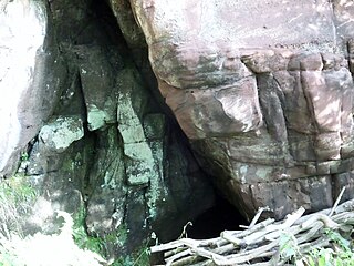
Peden's Cave is at least partly artificial and is set into a craggy outcrop of red sandstone rocks overlooking the River Lugar just below the farm of Auchinbay in East Ayrshire, Scotland, close to the town of Ochiltree. Traditionally it is said that this cave was used as a hiding place for Covenanters, including the famous Covenanter minister Alexander Peden in the 17th century, mainly during 'The Killing Time' of the 1680s.
The Holy Cave at Hunterston in the Parish of West Kilbride is associated with Saint Mungo, also known as St Kentigern and is often referred to as the Hawking Craig Cave; however two caves exist in the Hawking Craig Wood and 'Three Sisters' area of the cliffs, the other being Smith's Cave, better described as a rock shelter lying a short distance to the south. The main cave has been excavated and the finds indicate three periods of occupation over many centuries.

Wallace's Cave in the Lugar Gorge at Auchinleck in the Parish of Auchinleck, East Ayrshire is an 18th-century grotto, contemporary with Dr Johnson's Summerhouse which is also located on the Auchinleck Estate. It shows superior workmanship and is possibly the enlargement of a pre-existing cave. The cave or grotto lies downstream of the confluence of the Dippol Burn with the River Lugar and is reached via a once well formed path; however access is now hazardous due to the condition of the cliff edge path and the vertical drop into the River Lugar.

The Bickering bush (NS41863635) thorn grew near Caprington on the lands of Monksholm or Maxholm, Riccarton, East Ayrshire, Scotland. The old farm house at Maxholm sat in hollow on the old Caprington Castle estate and to the north and west its fields bordered the River Irvine. The thorn was located, as recorded on the OS map, near to the confluence of the Kilmarnock Water and the River Irvine, downstream of the Simon's Burn's confluence on the south bank of the river.
Craigie is a small village and parish of 6,579 acres in the old district of Kyle, now South Ayrshire, four miles south of Kilmarnock, Scotland. This is mainly a farming district, lacking in woodland, with a low population density, and only one village. In the 19th century, high quality lime was quarried here with at least three sites in use in 1832.

Murdoch's Cave, is a relatively small artificial cave created by William Murdoch (1754-1839) and his siblings in the soft red sandstone Lugar river bank cliff just upstream of the old Bellow Mill close to the confluence of the Bellow or Bello Water and the Glenmuir Water in Lugar, East Ayrshire, Scotland. The spelling 'Bellow' is used for consistency.

Minishant is a village bordering the A77 in the old county of Carrick, South Ayrshire, Scotland. It is located in Maybole Parish, 3+1⁄2 miles from Maybole and standing close to the River Doon. The village was originally named Culroy after the Culroy Burn that runs through it.
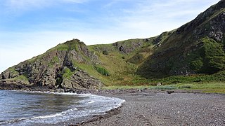
Balcreuchan Port or Balcruachan Port (NX0908878) is a bay and raised beach site in the parish of Colmonell, close to Bennane Head and Port Vad (NX091870) in South Ayrshire, Scotland. It is well known for its cave (NX099876) with its links to the legend of Sawney Bean and also for the unusual geology that is found in the bay. It was a minor fishing harbour up until the mid to late 19th century.


