Clonbeith Castle

Last updated

Clonbeith Castle
Auchentiber, North Ayrshire, Scotland
UK
Clonbeith.jpg
The front entrance of Clonbeith Castle showing ashlar and freestone on what may have once been a harled surface.
Scotland relief location map.jpg
Red pog.svg
Clonbeith Castle
Coordinates 55°40′30″N04°38′38″W / 55.67500°N 4.64389°W / 55.67500; -4.64389 Coordinates: 55°40′30″N04°38′38″W / 55.67500°N 4.64389°W / 55.67500; -4.64389
Grid reference grid reference NS338455
Site information
OwnerClonbeith Farm
Controlled by Cunningham clan
Open to
the public
Private
ConditionRuined
Site history
Built17th century
In useUntil 18th century
Materialsstone

The Castle of Clonbeith is in the old feudal Baillerie of Cunninghame, near Auchentiber, on a sideroad off the B778, in what is now North Ayrshire, Scotland.

Contents

Structure

It was a simple oblong mansion, about 40 by 23 feet (12 by 7 metres) with walls 2+12 ft (75 cm) thick. The ground floor was vaulted and the entrance was central, leading into a passage with a straight staircase branching off to the right up to the first floor hall. A wheel-stair in a square chamber led to the upper floors. The hall was lit by windows in three of the walls and had a large fireplace on one side, and a circular bow window on the opposite side, boldly projected on a series of corbels (see photograph). The Renaissance style door bears the date 1607. [1] The name "Clonbeith" is said to be derived from the Celtic words "Cluan" (grazing land) and "Beithe" (birch).[ citation needed ]

Lairds of Clonbeith

Given as "Klonbyith" by Pont in the 1690s it was then the property of William Cunningham, scion of this cadet branch of the Glencairn Cuninghames through those of Aiket Castle. He was married to Agnes who died in 1612.

Cunningham of Clonbeith coat of arms Cunninghame of Clonbeith coat of arms. 1825.jpg
Cunningham of Clonbeith coat of arms

In 1691 the Hearth Tax records show that "Clonbeith House" had five hearths and nineteen other dwellings were associated with the house. [2] Alexander Cuningham (sic) is said to have assaulted a professor in the College gardens at Glasgow and was forced to make an open acknowledgment of his faults in front of an assembly of his friends.

Together with around thirty other participants, it was John Cuningham shot and killed, the coup de gras, [3] Hugh, the fourth Earl of Eglinton in 1586 and was caught hiding in a chimney at Hamilton Palace and was "cut to pieces" by Robert, brother to Hugh and his supporters. Robert in the language of the time is said to have "honourably revenged" his brother's death, killing John Cunningham, [4] in Hamilton, possibly at Hamilton palace. [4]

James Cunningham of Clonbeith and Darnmuyle (1581) was the father of John Cunningham of Corsehill.

Robertson points out that the various branches of the family spell their name differently; as Cunningham for Baidland and Clonbeith, Cunninghame for Glencairn and Corsehill, Cuninghame for Caddel and Monkredding, and finally Cuningham for Glengarnock. [5] The Cunninghams of Clonbeith are usually referred to as being of "Clonbeith and Darnmyule", with Darmule being nearer Kilwinning.

Daniel Cunningham, whose wife was Mary Wallace, with the consent of his son William, sold the property to James Scott, Provost of Irvine in 1633. [6] In 1691 Walter, brother of James, sold the lands to Patrick Warner, Minister of Irvine.

William Cunninghams wife was Jean; in 1717 a reference is made to a George Cunningham of Clonbeith.

In 1698 the Monkredding estate was sold to Hugh Cuninghame of Clonbeith, Writer to the Signet, and became the family seat. [7]

Stories

Lady of Clonbeith

The "Leddy o'Clumbeith" is a ghost story told by Dr. Duguid [8] in the 1820s. A servant girl from the farm of Clonbeith was making her way to the Blair Tavern to keep a tryst when she fell into a mine shaft, horse and all, and was killed. Others say that her "lad" killed her and then jumped into the shaft after her. Her ghost is said to haunt the fields around Auchentiber.

Lady in the Peat

The Cowlinn Burn joining the Lugton Water at Montgreenan Castle. Cowlinnburn.JPG
The Cowlinn Burn joining the Lugton Water at Montgreenan Castle.
William Aiton's 1811 map showing 'Climbeith.' Map of Dunduff castle & roads.jpg
William Aiton's 1811 map showing 'Climbeith.'

Dr. Duguid [8] in around the 1840s records that near Clumbeith (Clonbeith) on the way to "Meg'swa's" he met Pate Glunch cutting peats. Pate was normally a still, dour man, but on this occasion he was highly animated and took the doctor to see the long dead corpse of a "bonnie lady" lying in a hole in the peat. She was around 18 to 20 years of age, had rosy cheeks, a sweet smile playing around her lips and blonde hair. Her identity was unknown, but a rumour linked her to the family of Montgreenan.

History

In around 1691 the Rev Patrick Warner, having purchased Clonbeith and likewise purchased Scott's lands in Irvine, went on to drain much of the "Loch of Irving" or Trindlemoss, later called Scott's Loch, after returning from exile in Holland. [9]

The Cowlinn Burn runs down to join the Lugton Water at the site of Montgreenan castle or the Bishop's Palace. A dwelling called Cowlinn is marked on the Thomson's 1820 map and a Clonbeith Mill was nearby.

A limestone pit and workers row existed near the castle in the 19th century, providing a constant supply for the local limekilns. [10]

A finely-shaped round and oval stone implement was found at Clonbeith or Clonkeith by Mr. Baird Kirkland in the 19th century. [11]

See also

Related Research Articles

<span class="mw-page-title-main">Clan Cunningham</span> Scottish clan

Clan Cunningham is a Scottish clan. The traditional origins of the clan are placed in the 12th century. However, the first contemporary record of the clan chiefs is in the thirteenth century. The chiefs of the Clan Cunningham supported Robert the Bruce during the Wars of Scottish Independence. In the 15th and 16th centuries, the Clan Cunningham feuded with the Clan Montgomery. Historically, the chief of Clan Cunningham held the title of Earl of Glencairn. However, in modern times the chief of the clan is Cunningham of Corsehill. On 18 December 2013, Sir John Christopher Foggo Montgomery Cunninghame, Baronet of Corsehill, was recognized by Lord Lyon as Clan Chief after the chiefship had been vacant for over 200 years.

<span class="mw-page-title-main">Barony and Castle of Corsehill</span> Barony in East Ayrshire, Scotland

The old Barony and castle of Corsehill lay within the feudal Baillerie of Cunninghame, near Stewarton, now East Ayrshire, Scotland.

<span class="mw-page-title-main">Kerelaw Castle</span>

Kerelaw Castle is a castle ruin situated on the coast of North Ayrshire, Scotland in the town of Stevenston.

<span class="mw-page-title-main">Auchenharvie Castle</span>

Auchenharvie Castle is a ruined castle near Torranyard on the A 736 Glasgow to Irvine road. Burnhouse lies to the north and Irvine to the south. It lies in North Ayrshire, Scotland.

The hamlet of Auchentiber is in North Ayrshire, Parish of Kilwinning, Scotland. Auchentiber is four miles northeast of Kilwinning on the Lochlibo Road, 2+14 mi (3.5 km) from the hamlet of Burnhouse and 2+12 mi (4 km) from the village of Barrmill. Grid Ref. NS3647. Some new housing has been built, but the settlement is still very much a hamlet. The settlement is on the Lugton Water, which runs into the River Garnock after running through Montgreenan and Eglinton Country Park in Irvine.

Riccarton is a village and parish in East Ayrshire, Scotland. It lies across the River Irvine from Kilmarnock, this river forming the boundary between Riccarton and Kilmarnock parishes, and also between the historical districts of Kyle and Cunningham. The name is a corruption of 'Richard's town', traditionally said to refer to Richard Wallace, the uncle of Sir William Wallace. The parish also contains the village of Hurlford.

Fergushill is a small community in North Ayrshire, Parish of Kilwinning, Scotland. The Barony of Fergushill was held by the Fergushill family of that Ilk and the area has a complex history.

<span class="mw-page-title-main">Montgreenan</span>

Montgreenan is an estate in North Ayrshire, Parish of Kilwinning, Scotland. The Lugton Water runs through the policies and farmland of Montgreenan. Nearby are the hamlets of Torranyard and Auchentiber.

<span class="mw-page-title-main">Kennox House</span> House in North Ayrshire, Scotland

Kennox House is situated on Kilwinning Road between Stewarton to Torranyard in North Ayrshire, Parish of Dunlop, Scotland. The house overlooks the Glazert Burn, which runs into the Annick Water at Watermeetings.

<span class="mw-page-title-main">Giffordland</span> Barony in North Ayrshire, United Kingdom

Giffordland is in North Ayrshire, Parish of Dalry (Cunninghame) in the former Region of Strathclyde, Scotland.

<span class="mw-page-title-main">Barony of Ladyland</span> Former barony in North Ayrshire, Scotland

The Barony of Ladyland was in the old feudal Baillerie of Cunninghame, near Kilbirnie in what is now North Ayrshire, Scotland.

<span class="mw-page-title-main">Seagate Castle</span>

Seagate Castle is a castle in North Ayrshire, in the town of Irvine, close to the River Irvine, Scotland. The castle was formerly a stronghold, a town house, and later a dower house of the Montgomery Clan. The castle overlooks the oldest street in Irvine, which was once the main route between the town and the old harbour at Seagatefoot, which by 1606, was useless and abandoned due to silting. The remains of the castle are protected as a scheduled ancient monument.

<span class="mw-page-title-main">Monkredding House, North Ayrshire</span>

Monkredding formed a small estate in the Parish of Kilwinning, North Ayrshire lying between Kilwinning and Auchentiber on the B778. The property was originally held by the Tironensian monks of Kilwinning Abbey and was the 'Monk's Garden', the rest home for the brothers. Monkcastle near Dalgarven was the abbot's country retreat. Monkredding remains in good condition and is in use as a private house in 2010.

<span class="mw-page-title-main">Lands of Lainshaw</span> The Lands Of Lainshaw Have Been In Place For Many Years And Was Used In The War.

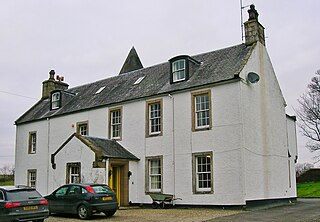
The Lands of Lainshaw lie in Strathannick and were part of the Lordship of Stewarton, in East Ayrshire, Scotland. Lainshaw House is a category B listed mansion, lying in a prominent position above the Annick Water and its holm in the Parish of Stewarton, Scotland. Part of the much older Lainshaw Castle is contained within the several later building phases of the present day Lainshaw House. The names 'Langshaw' or 'Langschaw' were used in historic times. Law Mount near the High and Laigh Castleton farms has been suggested as the site of the original castle, granted in the 12th century to Godfrey de Ross by Hugo de Morville.

<span class="mw-page-title-main">Lands of Ashgrove</span>

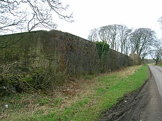
The Lands of Ashgrove, previously known as Ashenyards, formed a small estate in the Parish of Kilwinning, North Ayrshire, lying between Kilwinning and Stevenston. The Georgian mansion house was demolished in 1960, the substantial walled garden survives.

<span class="mw-page-title-main">Torranyard</span> Human settlement in Scotland

Torranyard is a small village or hamlet in North Ayrshire, Parish of Kilwinning, Scotland. It lies between the settlements of Auchentiber and Irvine on the A736 Lochlibo Road.

The Lands of Doura, Dawra, Dawray, DowreyDowray, Dourey or Douray formed a small estate, at one time part of the Barony of Corsehill and Doura, situated near the Eglinton Estate in the Parish of Kilwinning, North Ayrshire, Scotland.

<span class="mw-page-title-main">Murder of Hugh Montgomerie</span>

The Murder of Hugh Montgomerie, 4th Earl of Eglinton at the Annick Ford in Stewarton, East Ayrshire, Scotland, took place in 1586 as a consequence of a long running feud between the Montgomeries, Earls of Eglinton and the Cunninghames, Earls of Glencairn, families who were competing for power and influence locally and nationally. The significant repercussions of this act were felt throughout the county of Ayrshire and beyond. The spelling 'Montgomerie' is used throughout for both the family and Montgomery for the clan and clan and district names 'Cunninghame' in the same fashion.

The Lands of Dallars or Auchenskeith (NS463337) form a small estate in East Ayrshire, Hurlford, Kilmarnock, Parish of Riccarton, Scotland. The present mansion house is mainly late 18th-century, located within a bend of the Cessnock Water on the site of older building/s. "Dullers or Dillers" was changed to "Auchenskeith" or "Auchinskeigh" (sic) as well as other variants and then the name reverted nearer to the original form as "Dollars" and then finally "Dallars". Dallars lies 3.25 km south of Hurlford.

<span class="mw-page-title-main">Lands of Blacklaw</span> Human settlement in Scotland

The Lands of Blacklaw formed a small property of five merks worth, in the Lordship of Stewarton at the eastern extremity of Strathannick, between the hamlet of Kingsford in East Ayrshire and the East Renfrewshire boundary, Scotland. It was first recorded in 1484 in the Acta Auditorum. Black Law is a prominent whinstone crag lying above Blacklaw Hill Farm.

References

  1. MacGibbon, David & Ross, Thomas (1887 - 1892). The Castellated and Domestic Architecture of Scotland from the 12th to the 18th century. Vol. III. Reprint 1990. Pub. James Thin, Edinburgh. ISBN   0-901824-18-6. P. 374 - 375.
  2. Urquhart, Robert H. et al. (1998). The Hearth Tax for Ayrshire 1691. Ayrshire Records Series V.1. Ayr : Ayr Fed Hist Soc ISBN   0-9532055-0-9. P. 94
  3. Campbell, Thorbjørn (2003). Ayrshire. A Historical Guide. Edinburgh : Birlinn. ISBN   1-84158-267-0, P. 155
  4. 1 2 Ker, Rev. William Lee (1900) Kilwinnning. Pub. A.W.Cross, Kilwinning. P. 161.
  5. McNaught, Duncan (1912). Kilmaurs Parish and Burgh. Pub. A.Gardner.
  6. Paterson, James (1863-66). History of the Counties of Ayr and Wigton. V. - III - Cunninghame. J. Stillie. Edinburgh. p. 253.
  7. Paterson, James (1863-66). History of the Counties of Ayr and Wigton. V. - II - Cunninghame. J. Stillie. Edinburgh. p. 515.
  8. 1 2 Service, John (Editor) (1887). The Life & Recollections of Doctor Duguid of Kilwinning. Pub. Young J. Pentland. P. 81 - 83.
  9. Strawhorn, Page 60
  10. Ayrshire Notes (2003), Ayrshire Arch Nat Hist Soc. ISSN 1474-3531. Vol. 24, P. 4.
  11. Smith, John (1895), Prehistoric Man in Ayrshire. London : Elliot Stock. p. 60.

Sources