Broadstone Castle

Last updated

Broadstone lies close to the small village of Gateside in North Ayrshire, Scotland about half a mile east of Beith in the old Barony of Giffen.

Contents

Broadstone Castle
Barrmill, North Ayrshire, Scotland
UK grid reference NS4084831699
Broadstone Hall, Beith.JPG
Broadstone Hall near the site of the old castle
Scotland relief location map.jpg
Red pog.svg
Broadstone Castle
Coordinates 55°44′33″N4°36′39″W / 55.7426°N 4.610883°W / 55.7426; -4.610883
TypeTower
Site information
OwnerPrivate
Controlled byClan Montgomery
Open to
the public
No
ConditionRemoved
Site history
Built15th century
Built byJohn de Liddel
In useUntil 18th century
MaterialsStone

The history of Broadstone

The castle

Broadstone Farm, previously known as Hillhead. Broadstone Farm, Beith.JPG
Broadstone Farm, previously known as Hillhead.

The ruins of Braidstone or Broadstone Castle (NS 362 531) remained until about 1850. [1] but when Broadstonehall Farm buildings were being rebuilt, the castle was pulled down and its stones used in the building works; the Broadstone Crags, the site of the castle, remain however despite local quarrying. An avenue of trees and the vestiges of a garden had survived until the time of the building of the farm. [2] Its site was pointed out by Mr W Kerr of Broadstonehall in 1855.

The Barony mill

Most baronies had a water mill which was under the control of the laird or lord and to which the tenants were thirled or obliged to go to have their grain ground into flour. A proportion of the grain was taken as payment. Thirlage ended in the late 18th century and resulted in a number of mills being abandoned once market forces took a hold. The name 'Crooked Dam' relates to a small dwelling that once existed near the Powgree Burn and the remains of a mill pond site shows that this building was originally the miller's dwelling and the old barony mill once lay below the site of the crooked dam.

The barony and associated families

The Montgomerys

The Lordship of Giffen, included the Baronies of Giffen, Trearne, Hessilhead, Broadstone, Roughwood and Ramshead. [3]

The old lane leading to the castle's site. Broadstone Castle, Old entrance.JPG
The old lane leading to the castle's site.

The Barony of Braidstone (sic) was possessed by John de Lyddale (Liddel), Dominus de Bradestane in 1452. [4] Robert Montgomerie of Braidstone was second son of the 3rd Lord Montgomerie. Sir Hugh Montgomerie (1560–1636) was born here in 1560, son of Adam, 5th Laird of Braidstane. He married the daughter of John Montgomery of Hessilhead, and before 1568 he purchased lands from Hugh, third Earl of Eglinton. He left a daughter, Janet, who married Troilus, the second son of Adam Montgomery of Giffen. Andrew Nevin inherited the Monkredding estate in 1581 and married Janet, daughter of Adam Montgomery, IV laird of Broadstone Castle. Matthew Montgomerie was a resident at Broadstone, but was recorded as living at Bogstone in 1622. [5]

Hugh, first Viscount of the Great-Ardes, granted a mortgage on the lands of Broadstone to his brother-in-law, Sir John Shaw of Greenock in 1650. [6]

The Ulster connection

In 1603 Hugh Montgomery had accompanied King James I and VI on the journey to London to take possession of the English throne [7] and his surviving brother George was the Dean of Norwich, becoming one of the court chaplains to King James; (George later became Bishop of Derry). These close contacts enabled him to eventually obtain a one third portion of the lands of Con O'Neill, Lord of the Claneboys, in Ulster. [7] He entertained Con O'Neill at Broadstone and helped him to obtain a pardon for an accusation of 'waging war' against Queen Elizabeth I. [7] Mr James Hamilton, son of the minister of Dunlop, later James Hamilton, 1st Viscount Claneboye, also obtained a one third portion of these O'Neill lands.

Hugh Montgomery brought a colony of Irish Protestants over from his Irish estates in 1600 and later a colony of Protestants from the area were taken over to the Ardes and Clandebora areas of Ireland following the putting down of an Irish revolt. [8] Hugh was knighted in by King James in 1605, giving him precedency over his rival James Hamilton, [9] and he was created Viscount Montgomery of the Great Ardes on 3 May 1622; he died on 25 May 1636, aged 76. The Earl of Mount Alexander was his grandson, his title deriving from his descent from the family of Alexander, Earls of Stirling. [10]

Hugh Montgomery, 1st Viscount Montgomery (1560–1636), is known as one of the "founding fathers" of the Ulster-Scots along with James Hamilton, 1st Viscount Claneboye. Paterson, [11] the historian, records that the 'Laird of Braidstane's Scotch Colony', established in around 1606, was responsible for the introduction of linen weaving and manufacture to the area around Lurgan in Ireland; he also built mills, the harbour of Donaghadee, and repaired Port Montgomery (now Port Patrick). [10] Some of the family of Hugh Hammil of the nearby lands of Roughwood accompanied Hugh Montgomerie to Ireland and became established there as merchants in the Dublin area. [12]

The Shaws

The Brisbane Aisle in the grounds of Largs Old Kirk bears an armorial device with mullets for the Shaw and annulets for the Montgomeries of Broadstone. Largs, The Brisbane Aisle.JPG
The Brisbane Aisle in the grounds of Largs Old Kirk bears an armorial device with mullets for the Shaw and annulets for the Montgomeries of Broadstone.

As stated, Hugh Montgomery granted a mortgage on the lands of Broadstone to his brother-in-law, Sir John Shaw in 1650. [6] Sir John stayed at the castle occasionally until just after the year 1700. The Shaws gradually alienated the estate in feus until only the farm upon which the castle stood, remained. The family, from Greenock, were resident in 1650 when they purchased the estate. [4] The castle was last occupied in the early 18th century. [4]

The lands of Neubottle, now called Windyhouse, comprised Over and Nether Windyhouse and were feued by Sir John Shaw in 1674 to Thomas Shedden. The lands stayed with the Sheddens until James Shedden, who had two sons, one of whom, John joined the army and died in 1821, whilst the other, Thomas, emigrated to Canada. [13]

The Barrs

Robertson records a Mary Barr of Broadstone, daughter of J. Barr, who married Robert Buntine-Barr of Trearne and had a son Robert who died at sea. [14]

The Stewarts

In 1827 and 1829 Broadstone Hall was the residence of Sir M. S. Stewart. [15] [16] In 1842 Sir Michael Shaw Stewart, Baronet, retained the farm, together with the superiority of the whole. [17]

The Browns

Thought to be Hugh Brown of Broadstone. Hanging in Beith Library. Hugh Brown of Broadstone.JPG
Thought to be Hugh Brown of Broadstone. Hanging in Beith Library.
Memorial to Hugh Brown and Margaret Caldwell of Broadstone. Brown of Broadstone.JPG
Memorial to Hugh Brown and Margaret Caldwell of Broadstone.

In 1798 Hugh Brown, a merchant in Beith, had purchased Hill of Beith Castle. [18] He had purchased part of the Broadstone lands prior to this, as well as part of the lands of Geilsland, a portion of the lands of Crummock and part of the lands of Lyonshields in the barony of Hessilhead. [18] He built his mansion house at Brae-head House, later known as Crummock Park. [18] His son Hugh inherited in 1809 and another Hugh Brown of Broadstone inherited in 1857. [18]

A memorial at Beith Auld Kirk commemorates the second Hugh Brown of Broadstone (06-04-1787 to 02-01-1857) and his wife Margaret Caldwell (17-08-1783 to 04-06-1845); Hugh Brown Esq is listed as a Justice of the Peace and a member of the Beith gentry in the 1837 Beith Directory. [19]

Marshalland, Craig and Geilsland houses lie across the nearby Powgree Burn, together with the Spier's Old School Grounds, now a public parkland.

Bogston House and estate

This was a residence of the Montgomerie family and it lay between South Barr, Hayhills and Bogfaulds Farms in what is now DM Beith. Bogston was once a well wooded estate of 100 fertile acres (0.40 km2), with fine plantings, orchards and gardens. Part of the Giffen Barony, this property was feued out by the Earl of Eglinton to Robert Montgomerie in 1663. In its latter days Bogston was a farm, but following the creation of the munitions storage facility Bogston was demolished and is now only indicated by a small group of trees.

Windyhouse Farm

The Baney Hole near Windyhouse Farm. Baney Hole at Windyhouse.JPG
The Baney Hole near Windyhouse Farm.

Windyhouse Farm still stands at the junction of the road to Gateside and at one time another road ran past it, serving a number of farms and cottages such as Ward, Scoup, Bogfauld, Birsieknowe and Whitespot, that lay within what is now the MOD Beith base. Windyhouse had a retting pit for the preparation of flax. This required about four to six days of immersion and the waste retting water, which requires treatment to reduce harmful toxic elements before its release[ citation needed ], is rich in chemicals and was used as a liquid fertilizer. [20]

Close to Windyhouse was a deep pool, possibly a collapsed bell pit or limestone quarry, later used to dispose of dead animals, tree stumps, excess soil, etc; it is known as the 'Baney Hole' and is still visible as a wet area in the field. A number of small buildings existed nearby and the foundations of one are in the garden of Windyhouse, whilst another is located in the enclosure formed by hedge boundaries nearby. South Windyhouse Farm, once located next to the Hillhead Railway, no longer exists and no remains are visible. [20]

The old names for the lands of Windyhouse was 'Neubotle' a name of English origin. [13]

Windyhouse No.10 was an ironstone and clayband mine that was abandoned prior to October 1875. [21]

Quarrying, lime kilns and railways

William Aiton's 1811 map showing Broadstone. Map of Dunduff castle & roads.jpg
William Aiton's 1811 map showing Broadstone.
The tunnel / overbridge on the old Hillhead Railway. Overbridge, Hillhead line,beith.JPG
The tunnel / overbridge on the old Hillhead Railway.

Because of the underlying geology of this part of Ayrshire the presence of the many limestone quarries is to be expected. Lime kilns to produce lime for improving the soil, were a common feature of the countryside before the process became fully industrialised. Nettlehirst near Barrmill was one of the last large traditionally operated lime kilns to operate, surviving until the 1970s, however Broadstone has the substantial remains of one of the largest of the early stone built kilns. This must have created considerable pollution in the area, offset only by the employment it created. It sits right next to the limestone quarry which supplied it. The road running past is still known as 'Reek Road'.

The Ordnance Survey (OS) maps for 1858 show that the 'Hillhead Railway' ran to the quarry from Barkip Junction on the Ayrshire and Lanarkshire Railway branchline to Kilbirnie. At first sidings and a transfer system existed with a weighing machine at what was to become Brackenhills railway station, later a direct junction or transfer sidings were laid. The line did not survive into the 20th century and may have been narrow-gauge as indicated by the surviving tunnel / overbridge.

The old OS maps show that a marble quarry was located nearby, now filled in. [8] The limestone was of such quality that it was worked as marble and was in much demand for chimney pieces. [16]

Jean Deer

The old Crooked Dam millpond site on the Powgree Burn in the Fairy Glen. Fairy Glen on the Powgree, Gateside.JPG
The old Crooked Dam millpond site on the Powgree Burn in the Fairy Glen.

In Service's semi-fictional novel Jean Deer's husband worked at Broadstone Quarry in the late 19th century and died there following an accident of an unrecorded nature. She was forced to leave her Broadstone home, with her two young children and her baby, as it was required for another working man and his family. Jean took refuge in a ruinous cottage on the moors near Auchenmade. The winter of 1895 was exceptionally severe and come spring David Muir and Tom Service found her dead with two of her children.

Jean's baby was found alive in the bread oven, for this determined mother was found naked, having fed all her clothes to the fire to keep her baby warm until the last possible moment. She had previously burned all the furniture and the family had so little food that they had even drunk the oil from the lamp. [22]

The old quarry is locally known as Hennis Planting after a worker who died at the site.

The Hennis Planting and Broadstone's industrial archaeology

Related Research Articles

Barony and Castle of Corsehill Barony in East Ayrshire, Scotland

The old Barony and castle of Corsehill lay within the feudal Baillerie of Cunninghame, near Stewarton, now East Ayrshire, Scotland.

Hessilhead

Hessilhead is in Beith, North Ayrshire, Scotland. Hessilhead used to be called Hazlehead or Hasslehead. The lands were part of the Lordship of Giffen, and the Barony of Hessilhead, within the Baillerie of Cunninghame and the Parish of Beith. The castle was situated at grid reference NS380532.

Barony and Castle of Giffen Barony in the former District of Cunninghame, now North Ayrshire

The Barony of Giffen and its associated 15th-century castle were in the parish of Beith in the former District of Cunninghame, now North Ayrshire. The site may be spelled Giffen or Giffin and lay within the Lordship of Giffin, which included the Baronies of Giffen, Trearne, Hessilhead, Broadstone, Roughwood and Ramshead; valued at £3,788 9s 10d. The Barony of Giffen comprised a number of properties, including Greenhills, Thirdpart, Drumbuie, Nettlehirst and Balgray, covering about half of the parish of Beith. Giffen was a hundred merk land, separated from the Barony of Beith, a forty-pound land, by the Powgree Burn which rises on Cuff hill. The Lugton Water or the Bungle Burn running through Burnhouse may have been the Giffen barony boundary with that of the adjacent barony and lands of Aiket castle.

Gateside, North Ayrshire Human settlement in Scotland

Gateside is a small village in North Ayrshire, Scotland about 12 mile east of Beith on the B777.

Barrmill, North Ayrshire Small village in North Ayrshire, Scotland

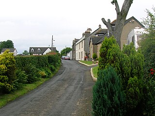
Barrmill is a small village in North Ayrshire, Scotland about 1+12 miles east of Beith on the road to Burnhouse and Lugton. Locally it is known as the Barr.

Spiers School

Spier's School, at Beith, in North Ayrshire, Scotland was opened in 1888 and closed in 1972. The school, now demolished, was built using Ballochmyle red sandstone and was reminiscent of the ancient Glasgow University. The school motto was 'Quod verum tutum'. The gardens and woodlands are open to the public at all times.

Barony of Aiket Barony in Scotland

The Barony of Aiket with its castle, lay within the old feudal bailiary of Cunninghame. The barony lands equate to the extant Parish of Dunlop, East Ayrshire, Scotland.

Skelmorlie Castle

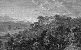
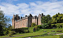
Skelmorlie Castle stands on the eastern shore of the Firth of Clyde, Scotland, at the north-western corner of the county of Ayrshire. The structure dates from 1502, and was formerly the seat and stronghold of the Montgomery Clan. The modern village of Skelmorlie lies to the north of the castle.

Hill of Beith Castle

The old Barony and castle, fortalice, or tower house of Hill of Beith lay in the feudal Regality of Kilwinning, within the Baillerie of Cunninghame, and the Sherrifdom of Ayr, now the Parish of Beith, North Ayrshire, Scotland.

Loch Brand

Loch Brand or Loch of Boghall was a loch situated in a depression between the Grange Estate, Crummock, Hill of Beith Castle site and Boghall in the Parish of Beith, North Ayrshire, Scotland. The loch was fed by the Grange Burn and surface runoff, such as from the old rig and furrows indicated by Roy's Maps of the mid 17th century. The loch was drained by the Boghall Burn that runs passed the 'Court Hill' and into Powgree Burn at Gateside.

Nettlehirst

Nettlehirst or Nettlehurst was a small mansion house (NS365504) and estate in the Parish of Beith, near Barrmill in North Ayrshire, Scotland. The house was built in 1844 and burned down in 1932.

Lands of Cocklebie Human settlement in Scotland

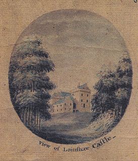
The Lands of Cocklebie or Cocklebee formed an estate possessing a common border with the estates of Lainshaw, the Corsehill, and the town of Stewarton, East Ayrshire, Parish of Stewarton, Scotland.

Lands of Bogston

Bogston or later Bogstone was a small estate in the old Barony of Giffen near Barrmill in the Parish of Beith, North Ayrshire, once held by collateral descendants of the Montgomeries of Broadstone. The estate covered 160 acres or around 65 hectares, its rental in 1896 being £180 per annum.

The Lands of Roughwood

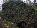
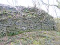
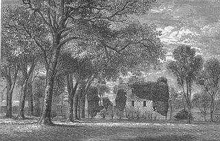
Roughwood once Ruchwood is a farm, originally a estate, possessing at one time a small tower castle. Roughwood is situated near to the town of Beith in North Ayrshire, Scotland; the lands lay within the old Lordship of Giffen.

Greenhills, North Ayrshire Human settlement in Scotland

Greenhills is a small village or hamlet in North Ayrshire, Parish of Beith, Scotland. It lies between the settlements of Barrmill and hamlet of Burnhouse on a crossroads of the B706 and the lanes to Nettlehirst and Tandlehill via Thirdpart. It is named after the 'Green Hill' an artificial mound, a Moot, Law or Justice hill that once stood here. The settlement lay within the old Barony of Giffen; the castle no longer exists. The village lies within Barrmill and District Community Association's area and is also covered by Beith Community Council.

Barony of Kersland

The remains of the old castle of Kersland lie about 1.5 miles to the north-east of the town of Dalry in North Ayrshire, Scotland, in the old Barony of Kersland. The River Garnock lies nearby.

Lands of Doura

The Lands of Doura, Dawra, Dawray, DowreyDowray, Dourey or Douray formed a small estate, at one time part of the Barony of Corsehill and Doura, situated near the Eglinton Estate in the Parish of Kilwinning, North Ayrshire, Scotland.

Lands of Marshalland

The lands of Marshalland, Marsheland, Marsheyland or Marshyland were part of the holdings of the Barony of Beith, Regality of Kilwinning and Bailiary of Cuninghame. They became the property of the Lyle family, then the Shedden family, passing next to the Spier's family before finally becoming part of the Spier's Trust lands. The laird's house and farm were demolished in the 1960s.

Lands of Broomlands Human settlement in Scotland

The lands of Broomlands or Broumlands formed a small country estate about a mile to the east of Irvine, North Ayrshire, Scotland situated on the east bank of the Annick Water in the Parishes of Dreghorn and Irvine.

Murder of Hugh Montgomerie

The Murder of Hugh Montgomerie, 4th Earl of Eglinton at the Annick Ford in Stewarton, East Ayrshire, Scotland, took place in 1586 as a consequence of a long running feud between the Montgomeries, Earls of Eglinton and the Cunninghames, Earls of Glencairn, families who were competing for power and influence locally and nationally. The significant repercussions of this act were felt throughout the county of Ayrshire and beyond. The spelling 'Montgomerie' is used throughout for both the family and Montgomery for the clan and clan and district names 'Cunninghame' in the same fashion.

References

Notes
  1. Porterfield, Page 31.
  2. Paterson, Page 80.
  3. Robertson, Page 285.
  4. 1 2 3 Coventry, Page 246
  5. Paterson, Page 81
  6. 1 2 Campbell, Page 147
  7. 1 2 3 Jamieson, Page 9
  8. 1 2 Robertson, Page 281.
  9. The New Statistical Account]
  10. 1 2 Jamieson, Page 10
  11. Paterson, Page 48.
  12. Robertson, Page 373.
  13. 1 2 Dobie, Page 345
  14. Robertson, Page 155
  15. Aitken
  16. 1 2 Reilly, Page 35
  17. Reilly, Page 55
  18. 1 2 3 4 Dobie, Page 134
  19. "Pigot's Beith Directory". Archived from the original on 2010-07-03. Retrieved 2009-10-12.
  20. 1 2 Gilbert
  21. Mines Department, Page 10
  22. Service, Pages 156 - 157.
Sources
  1. Aitken, Robert (1829). The Parish Atlas of Ayrshire - Cunninghame. Edinburgh : W. Ballantine.
  2. Campbell, Thorbjørn (2003). Ayrshire. A Historical Guide. Edinburgh : Birlinn. ISBN   1-84158-267-0.
  3. Catalogue of Abandoned Mines (1931). Mines Department. Vol. V. (Scotland). HMSO.
  4. Coventry, Martin (2010). Castles of the Clans. Musselburgh : Goblinshead. ISBN   1-899874-36-4.
  5. Dobie, James D. (ed Dobie, J.S.) (1876). Cunninghame, Topographized by Timothy Pont 1604–1608, with continuations and illustrative notices. Glasgow: John Tweed.
  6. Gilbert, Thomas & Grace (2010). Windyhouse Farm.
  7. Jamieson, Sheila (1997). Our Village. Greenhills Women's Rural Institute.
  8. Paterson, James (1866). History of the Counties of Ayrs and Wigton. Vol. Iv. Cuninghame. Part 1. Edinburgh : James Stillie.
  9. Paterson, James (1871). Autobiographical Reminiscences. Glasgow : Maurice Ogle & Co.
  10. Porterfield, S. (1925). Rambles Round Beith. Beith : Pilot Press.
  11. Reilly, Emilia Georgiana Susanna (1842). A Genealogical History of the family of Montgomery. Privately published.
  12. Robertson, George (1820). A Topographical Description of Ayrshire: More particularly of Cunninghame, etc. .... Irvine : Cunninghame Press.
  13. Service, John (1913), The Memorables of Robin Cummell Paisley : Alexander Gardner.
  14. The New Statistical Account of Scotland. 1845. Vol. 5. Ayr - Bute. Edinburgh : Blackwood & Sons.