The Lands of Pitcon

Last updated

The Pitcon Knoll. Pitcon Estate.JPG
The Pitcon Knoll.

The Lands of Pitcon, previously Potconnel [1] now form a small estate of around 100 acres in the Parish of Dalry, North Ayrshire in the old Barony of Dalry. The present category B listed [2] Georgian mansion house (OS NS 229879, 650628) dating from 1787, replaces an older castellated dwelling. Pitcon lies on the outskirts of Drakemyres, now a suburb of Dalry, close to the confluence of the Rye Water, River Garnock, and the Mains Burn, [3] standing on a low knoll. Such a marshy area would have provided a degree of protection to the old castle.

Contents

History

The Mansion house and walled garden

The Pitcon Burn and the view towards Boag Farm Pitcon Burn - geograph.org.uk - 607935.jpg
The Pitcon Burn and the view towards Boag Farm
Scotland relief location map.jpg
Red pog.svg
Ashgrove
The location of the Pitcon Estate, North Ayrshire

The OS Name Book of 1856 records that the western end of the building had been part of the ancient dwelling and a summer house bore the arms of the Boyd family, and a stone inscribed 'Thomas Boyd 1530'. By 1956 the ancient part of Pitcon had been demolished and the stones noted in 1856 were in the wall of the walled garden. A marriage stone inscribed '1660 RB AW' is located in the wall of an outhouse. [4]

Paterson records that the old manor house stood close to the present building. [5]

The present Pitcon mansion house mainly dates from 1787, a new wing having been added in the 1920s to plans drawn up by James Houston. [3] An old stone dated 1660 is incorporated into the laundry house. [3] The walled garden dates from the late 18th century.

The estate

Tree planting on the site of old ironstone pits. Pitcon tree planting.JPG
Tree planting on the site of old ironstone pits.

The Lands of Pitcon were "a seven merk land of old extent" and were given to Thomas Boyd by his father, Alexander Boyd, who was in turn given the lands by his father, Robert, the first Lord Boyd, also Great Chamberlain of Scotland. [1] Thomas Boyd in 1608 also held 'Linget-rig' (Lintseedridge) in Over Mains of Pitcon, and Nether Mains of Pitcon. He also held the Chapel Lands near Fairlie Crevoch in the parish of Stewarton. [6]

In the mid 19th century a valuable stratum of ironstone was discovered and exploited, [7] leaving substantial mining remnants from two pits, their mineral railways and waste tips, that were close by. Several other ironstone pits were in the vicinity as shown by the OS maps of the time. [8] Extensive tree planting has helped to hide the scars of this industrial activity of the past. [9]

The lodge house, Pitcon Cottage, is marked on mid 18th century OS maps but no longer exists. A network of estate roads existed with a ford crossing the River Garnnock before the mineral railway was built. [8]

The Lairds of Pitcon

The Pitcon family are recorded as holders of the property since the 13th century, [10] [11] Sir Robert Pitcon is recorded in 1488, William Pitcon was the Chamberlain of Kilwinning in 1557 and Hugh Pitcon is recorded as holding Lintseed Ridge in 1693. In 1520, Pitcon was held by Alexander Pitcon of that Ilk, [12] indicating that the family name was the same as the name of their property. The surname 'Pitcon' is rarely encountered, however the contraction 'Conn' is more commonly encountered. [1]

The Boyds

The Coat of Arms of the Boyds of Pitcon. Boyd of Pitcon.jpg
The Coat of Arms of the Boyds of Pitcon.
The Coat of Arms of the Cuninghames of Caddel. Cuninghamecaddel.jpg
The Coat of Arms of the Cuninghames of Caddel.

King Robert the Bruce conferred the Barony of Dalry upon Sir Robert Boyd and the first Boyd of Pitcon was Thomas Boyd. [13] In 1632 Thomas was styled of Lin, a nearby property customarily spelled Lyn or Lynn. The Boyds had acquired part of the minor barony of Lynn in 1532, when John Lynn "for a sum of money to him paid, sold" to Thomas Boyd "forty-shilling land of the old extent of Lyn". [14] The earliest reference to a Boyd of Pitcon in all the document extracts at the website of the National Archives of Scotland is dated 1571 and relates to Thomas Boyd of Pitcon. [15]

Thomas was the brother of Robert Boyd of Kilmarnock, married Marion Fairlie, daughter of John Fairlie of that Ilk and was buried at the family burial ground in Kilmarnock. He predeceased his wife whose second husband was James Stewart, giving rise to the line that led to the Marquess of Bute. His son, also Thomas, together with his brother Richard supported Mary Queen of Scots and fought at the Battle of Langside; they were both pardoned. [6]

In 1608 Thomas Boyd, son of Thomas, inherited and married Isabell, heiress of William Glen of Barr, dying young in 1617 however and succeeded by his son Robert, who married Anna Blair in 1633, [16] the daughter of Brice Blair of that Ilk. Bryce Boyd inherited the lands from his father in about 1650 and married Isabell Henderson, daughter of Henderson of Baike. This Isabell later married Alexander Crawfurd of Fergushill as Bryce Boyd died in 1660. [17] Thomas Boyd, heir to Bryce, married Agnes Scott and had a son Robert who inherited, [18] dying before 1725 when his son Thomas inherited; this heir was the last of the Pitcon Boyd male line and sold Pitcon to George MacRae. He was comptroller of the Customs in Irvine and had four daughters, three of whom married, however the sons did not marry. [18] [19] Thomas Boyd in 1696 married Janet, daughter of John Cunninghame of Caddel. [20]

The Arms of the Boyds of Pitcon were the same as the Kilmarnock branch of the family, with the motto; "Spes mea in Colis" (My hope is in heaven). [19]

Macrae, Robison and others

George MacRae or McCree, a wine merchant from Ayr, purchased the lands in 1770 from the last of the Boyds of Pitcon and after the ruin of the originally Ayr based Douglas, Heron and Company's Bank [21] the estate was sold by his creditors in 1787, James Robison being the purchaser. [3] Mrs Ann Robison Orr, his sister, inherited as he had no direct heir, and she left the property to a distant relative, John Cockburn, on the condition that he took the name Robison. In the 1829 John Cockburn sold Pitcon for £13,000 to Dr Ebenezer Smith of Kilmarnock, [1] who in turn sold the estate to a Glasgow based merchant, Alexander Alison of Lintseedridge. [7] The Eglinton Iron Company, in the persons of James Baird of Camusdoon and others, held the Pitcon lands in 1874. [7]

The McCosh family held Pitcon since at least the 1920s. In 2011 the estate with 96.87 acres of land was purchased by Dr Michael Boles and Mrs Robin Boles, LVO.

Micro-history

The Pitcon driveway road end Pitcon road end.JPG
The Pitcon driveway road end

Thomas Boyd, the last of Pitcon, was Baillie for the area to the Right Hon. Patrick Lindsay-Crawfurd, 2nd Viscount of Garnock in 1730. [18] John Boyd of Pitcon married Marion Cunninghame of Carlung, the last of her line in the early 18th century. [22] Thomas Boyd, son of Bryce, was a Commissioner of Supply for the County of Ayr in 1695 and 1703. His daughter Jane married Andrew Macredie of Perceton. [18] The laird of Pitcon held Monkcastle at one time, having obtained it from George Hay, and later it passed to John Wallace, minister of Largs in the 17th century. [23] Saint Margaret's parish church in Dalry contains an oak armorial pew decoration, the shield of Blair impaled with that of Boyd of Pitcon, and this now adorns a transept wall. [24]

A Pitcon Brickworks was located near Dalry. [25]

See also

Related Research Articles

Barony and Castle of Corsehill Barony in East Ayrshire, Scotland

The old Barony and castle of Corsehill lay within the feudal Baillerie of Cunninghame, near Stewarton, now East Ayrshire, Scotland.

Dunlop is a village and parish in East Ayrshire, Scotland. It lies on the A735, north-east of Stewarton, seven miles from Kilmarnock. The road runs on to Lugton and the B706 enters the village from Beith and Burnhouse.

Kerelaw Castle

Kerelaw Castle is a castle ruin owned by a surviving male descendant of the Hamilton family, Logan Neely. It is situated on the coast of North Ayrshire, Scotland in the town of Stevenston.

Hessilhead

Hessilhead is in Beith, North Ayrshire, Scotland. Hessilhead used to be called Hazlehead or Hasslehead. The lands were part of the Lordship of Giffen, and the Barony of Hessilhead, within the Baillerie of Cunninghame and the Parish of Beith. The castle was situated at grid reference NS380532.

Montgreenan

Montgreenan is an estate in North Ayrshire, Parish of Kilwinning, Scotland. The Lugton Water runs through the policies and farmland of Montgreenan. Nearby are the hamlets of Torranyard and Auchentiber.

Kennox House House in North Ayrshire, Scotland

Kennox House is situated on Kilwinning Road between Stewarton to Torranyard in North Ayrshire, Parish of Dunlop, Scotland. The house overlooks the Glazert Burn, which runs into the Annick Water at Watermeetings.

Giffordland Barony in North Ayrshire, United Kingdom

Giffordland is in North Ayrshire, Parish of Dalry (Cunninghame) in the former Region of Strathclyde, Scotland.

Craigie Castle

Craigie Castle, in the old Barony of Craigie, is a ruined fortification situated about 4 miles (6.4 km) southeast of Kilmarnock and 1 mile (1.6 km) southeast of Craigie village, in the Civil Parish of Craigie, South Ayrshire, Scotland. The castle is recognised as one of the earliest buildings in the county. It lies about 1.25 miles (2 km) west-south-west of Craigie church. Craigie Castle is protected as a scheduled monument.

Skelmorlie Castle

Skelmorlie Castle stands on the eastern shore of the Firth of Clyde, Scotland, at the north-western corner of the county of Ayrshire. The structure dates from 1502, and was formerly the seat and stronghold of the Montgomery Clan. The modern village of Skelmorlie lies to the north of the castle.

Castle and Barony of Robertland

The Castle and Barony of Robertland is located near Stewarton, off the B769 road, in the old district of Cunninghame, Parish of Stewarton, and now part of East Ayrshire, Scotland.

Lands of Lainshaw The Lands Of Lainshaw Have Been In Place For Many Years And Was Used In The War.

The Lands of Lainshaw lie in Strathannick and were part of the Lordship of Stewarton, in East Ayrshire, Scotland. Lainshaw House is a category B listed mansion, lying in a prominent position above the Annick Water and its holm in the Parish of Stewarton, Scotland. Part of the much older Lainshaw Castle is contained within the several later building phases of the present day Lainshaw House. The names 'Langshaw' or 'Langschaw' were used in historic times. Law Mount near the High and Laigh Castleton farms has been suggested as the site of the original castle, granted in the 12th century to Godfrey de Ross by Hugo de Morville.

Polkelly Castle

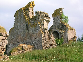
Polkelly Castle, also Pokelly, was an ancient castle located near Fenwick, at NS 4568 4524, in the medieval free Barony of Polkelly, lying north of Kilmarnock, Parish of Fenwick, East Ayrshire, Scotland. The castle is recorded as Powkelly (c1747), Pockelly (c1775), Pow-Kaillie, Ponekell, Polnekel, Pollockelly, Pollockellie, Pokellie, Pothelly, Pathelly Ha' and Polkelly. The name is given circa 1564 as Powkellie when it was held by the Cunninghams of Cunninghamhead.

Barony of Kersland

The remains of the old castle of Kersland lie about 1.5 miles to the north-east of the town of Dalry in North Ayrshire, Scotland, in the old Barony of Kersland. The River Garnock lies nearby.

Swindridgemuir House and estate were composed of the 'Lands of Swindridgemuir' and the dwelling house about two miles north-east of Dalry in the old Barony of Kersland, about a mile and a half north of the Blair Estate, North Ayrshire, Scotland. The spelling on the family memorials at Ayr Auld Kirk is 'Swindrigemuir'.

Lands of Willowyard

The ancient lands of Willowyard, Willieyeards, Williyard or Willizeards were part of the holdings of the Regality of Kilwinning, Barony of Beith, and Bailiary of Cuninghame. They later became the property of the Montgomerie family before being sold to the Simson family in 1723. The manor house still survives as part of a business premises and the nearby industrial estate and whisky bond carry the name 'Willowyards'.

Lands of Marshalland

The lands of Marshalland, Marsheland, Marsheyland or Marshyland were part of the holdings of the Barony of Beith, Regality of Kilwinning and Bailiary of Cuninghame. They became the property of the Lyle family, then the Shedden family, passing next to the Spier's family before finally becoming part of the Spier's Trust lands. The laird's house and farm were demolished in the 1960s.

Fairlie Castle

Fairlie Castle is a restored oblong tower castle located on a natural rounded knoll situated above a precipitous section of the Fairlie Glen near the town of Fairlie in the old Barony of Fairlie, Parish of Largs, North Ayrshire, Scotland. It was built by the now extinct family, the Fairlies of that Ilk and survives in a fairly good state of preservation. It is a protected scheduled monument.

Lands of Borland Human settlement in Scotland

The Lands of Borland formed an estate lying between Aiket Castle and the town of Dunlop, East Ayrshire, Parish of Dunlop, Scotland. The laird's house at Borland stood near the Sandy Ford over the Glazert Water. The names Bordland, Boreland, Borland, Laigh Borland, Low Borland and Nether Borland have all been applied to the site of the laird's house.

Lands of Templehouse Human settlement in Scotland

The Lands of Templehouse formed a small estate lying between Aiket Castle and the town of Dunlop, East Ayrshire, Parish of Dunlop, Scotland. The laird's house at Templeland of Dunlop Hill, to give it its formal name, stood near to the ancient road leading from Dunlop to Kirkwood and on to Kennox. The lands were held by the Knights Templar until a date prior to 1570 when the Gemmells of Templehouse were granted the property and remained there until 1962, a period of around 500 years. The spelling 'Gemmell' is used for consistency except where otherwise denoted.

The Lands of Dallars or Auchenskeith (NS463337) form a small estate in East Ayrshire, Hurlford, Kilmarnock, Parish of Riccarton, Scotland. The present mansion house is mainly late 18th-century, located within a bend of the Cessnock Water on the site of older building/s. "Dullers or Dillers" was changed to "Auchenskeith" or "Auchinskeigh" (sic) as well as other variants and then the name reverted nearer to the original form as "Dollars" and then finally "Dallars". Dallars lies 3.25 km south of Hurlford.

References

Notes;

  1. 1 2 3 4 Dobie, Page 356
  2. Historic Environment Scotland. "Pitcon House and Walled Garden (Category B Listed Building) (LB1251)" . Retrieved 25 March 2019.
  3. 1 2 3 4 Love, Page 79
  4. RCAHMS Retrieved : 2011-03-27
  5. Paterson, Page
  6. 1 2 Paterson, Page 187
  7. 1 2 3 Dobie, Page 357
  8. 1 2 OS Map Retrieved : 2011-03-27
  9. Google Maps Retrieved : 2011-03-27
  10. Coventry, Page 478
  11. Coventry, Page 54
  12. National Archives of Scotland Ref. No. GD3/1/1/17/8
  13. Paterson, Page 186
  14. Paul, James Balfour, F.S.A. Scot., and Thomson, John Maitland, M.A., Advocates, "The Register of the Great Seal of Scotland A.D. 1513-1546", Edinburgh (1883)
  15. National Archives of Scotland Ref. No. GD8/222
  16. Paterson, Page 188
  17. Robertson, Page 197
  18. 1 2 3 4 Paterson, Page 189
  19. 1 2 Clan Boyd Retrieved : 2011-03-27
  20. Robertson, Page 286
  21. Fergusson, Page 181
  22. Robertson, Page 124
  23. Dobie, Page 331
  24. "Dalry parish church". Archived from the original on 21 July 2012. Retrieved : 2011-03-27[ dead link ]
  25. RCAHMS Retrieved : 2011-03-27

Sources;

  1. Coventry, Martin (2010). Castles of the Clans. Musselburgh : Goblinshead. ISBN   1-899874-36-4
  2. Dobie, James D. (ed Dobie, J.S.) (1876). Cunninghame, Topographized by Timothy Pont 1604–1608, with continuations and illustrative notices. Glasgow : John Tweed.
  3. Ferguson, Sir James (2004). By the Water of Girvan. Glasgow : The Grimsay Press.
  4. Love, Dane (2003). Ayrshire : Discovering a County. Ayr : Fort Publishing. ISBN   0-9544461-1-9.
  5. Paterson, James (1863–66). History of the Counties of Ayr and Wigton. V. - II - Cunninghame. Edinburgh: J. Stillie.
  6. Robertson, George (1823). A Genealogical Account of the Principal Families in Ayrshire, more particularly in Cunninghame. Irvine.

Coordinates: 55°43′09″N4°42′36″W / 55.7191°N 4.7099°W / 55.7191; -4.7099