Marriage stone

Last updated

A marriage stone, nuptial stone or lintel stone [1] is usually a stone, rarely wood, lintel carved with the initials, coat of arms, etc. of a newly married couple, usually displaying the date of the marriage. They were very popular until Victorian times, but fell out of general use in the 20th century. Many survive for aesthetic value, particularly where well carved or of historic value. Many are part of or in the grounds of a listed building or in conservation areas.

Contents

Purpose

A marriage stone at Woodside House, Parish of Beith. Marriagestone10.jpg
A marriage stone at Woodside House, Parish of Beith.

Marriage stones serve as a record of a marriage, the joining together of two families, although in Jersey, [3] where they are probably more common than elsewhere in the British Isles, they rarely, if ever, bear the date of a marriage, but mostly the names of the occupants of a property at the time it was built, restored or extended, or when it was acquired by those whose initials appear on the stone [4] especially important in aristocratic families and also sometimes practised amongst the newly established and monied middle classes. They were sometimes added to a building which was constructed specifically as the new family home for the married couple, especially when the dowry was large, or were carved into a pre-existing lintel over the main entrance or over a fireplace. [1] The stones also clearly indicated the ownership of the building to onlookers at the time as well as serving as a record for posterity of both marital bliss and often also of social advancement. [5]

Datestones are a subtly different category in that they primarily commemorate the construction of a building rather than record a marriage. They may do both and such symbolism as entwined hearts [1] indicates that they serve to perform both functions. Date stones are far more common than marriage stones and are found on most types of vernacular buildings, indeed they are in vogue again today (2007), partly through the influence of the significance of the 2000 millennium year. Some buildings have both marriage stones and datestones, such as 'The Hill' at Dunlop, which has a date stone on the 'mansion house' and even the gateposts are dated.

Positioning

One of many 16th century door lintels in Edinburgh's Old Town 16thC lintel, Edinburgh Old Town.jpg
One of many 16th century door lintels in Edinburgh's Old Town

The stones were placed where they would be easily and frequently seen by visitors, usually on the lintel above the front door of a house, above a fireplace or in a prominent position facing the entrance or in the gardens, such as above a doorway in wall. [1] Many are no longer visible having been covered over in some way such as when older buildings have been extended, porches built, etc. Often the husband's initials were on the left and the wife's were on the right. [6]

Design

Usually carved into stone or sometimes wood, they can be very detailed, with usually only the initials of the married couple, the date of the marriage and sometimes the coat of arms of the two families, just those of the husband and very rarely the combined coats of arms of both families. In some cases the adornment was religious in nature, such as at 'The Hill' farm mansion house (see photograph) or an artistic design simply placed there as an ornamentation. The designs are found cut into the stone or standing proud of the rock face. Originally some of these stones would have been brightly painted and adorned with gilt. [5]

Examples

Scotland

Marriage stone from Fullarton. Marriage Stone, Fullarton, Troon.JPG
Marriage stone from Fullarton.
Marriage stone from Parkhill House. Parkhill House Datestone, Dalry.JPG
Marriage stone from Parkhill House.
Castle Menzies - Showing Marriage Escutcheon Inserted in Wall, 1571 Marriage Stone at Castle Menzies, Red and White Book of Menzies, 1908.jpg
Castle Menzies – Showing Marriage Escutcheon Inserted in Wall, 1571
Gibson marriage stone, The Cuff, Gateside. Gibson Marriage Stone at The Cuff, Beith.JPG
Gibson marriage stone, The Cuff, Gateside.
Marriage stone at Kirktonhall House. Kirkton Hall marriage stone.JPG
Marriage stone at Kirktonhall House.

Wales

A wooden lintel marriage stone Penybenglog.jpg
A wooden lintel marriage stone

Ireland

Jersey

Modern marriage stones

A two-ton Scottish granite Marriage stone was created for the wedding of Prince Charles and Camilla Parker-Bowles, 9 April 2005. Unusually this has carvings on both sides.

Stones associated with marriage

The Treustein

Many synagogues in Germany featured a Treustein, or "marriage stone" at which a goblet was shattered at the culmination of the wedding ceremony. [12]

Hindu weddings

In Hinduism, it is customary in a marriage ceremony for the bride to stand on a stone slab or millstone to symbolise her commitment to the marriage during times of difficulty, in a practice known as Shila Arohan (Ascending the stone). [13]

Holed stones

On the crest of a hill near the village of Doagh in County Antrim, Northern Ireland, sits a Bronze Age standing stone or 'holestone'. It is 1.5 metres high, with a 10 cm diameter hole cut into it. It is not known why the Holestone was created, but has attracted visitors seeking external love and happiness since at least the 18th century. Upon reaching the Holestone couples undertake a traditional ceremony where the woman reaches her hand through the circular hole and her partner takes it, thus pledging themselves to love each other forever. There is a legend regarding a black horse that inhabits the field in which the holestone is situated. According to this legend a young couple were married at the stone, but the groom committed an act of adultery on their wedding night. For this act he was cursed by the stone to spend eternity as a horse, never dying, and never able to leave that field.

See also

Related Research Articles

Barony and Castle of Corsehill Barony in East Ayrshire, Scotland

The old Barony and castle of Corsehill lay within the feudal Baillerie of Cunninghame, near Stewarton, now East Ayrshire, Scotland.

Dunlop, East Ayrshire Human settlement in Scotland

Dunlop is a village and parish in East Ayrshire, Scotland. It lies on the A735, north-east of Stewarton, seven miles from Kilmarnock. The road runs on to Lugton and the B706 enters the village from Beith and Burnhouse.

Lugton Human settlement in Scotland

Lugton is a small village or hamlet in East Ayrshire, Scotland with a population of 80 people. The A736 road runs through on its way from Glasgow, 15 miles (24.1 km) to the north, to Irvine in North Ayrshire. Uplawmoor is the first settlement on this 'Lochlibo Road' to the north and Burnhouse is to the south. The settlement lies on the Lugton Water which forms the boundary between East Ayrshire and East Renfrewshire as well as that of the parishes of Dunlop and Beith.

Barony and Castle of Giffen Barony in the former District of Cunninghame, now North Ayrshire

The Barony of Giffen and its associated 15th-century castle were in the parish of Beith in the former District of Cunninghame, now North Ayrshire. The site may be spelled Giffen or Giffin and lay within the Lordship of Giffin, which included the Baronies of Giffen, Trearne, Hessilhead, Broadstone, Roughwood and Ramshead; valued at £3,788 9s 10d. The Barony of Giffen comprised a number of properties, including Greenhills, Thirdpart, Drumbuie, Nettlehirst and Balgray, covering about half of the parish of Beith. Giffen was a hundred merk land, separated from the Barony of Beith, a forty-pound land, by the Powgree Burn which rises on Cuff hill. The Lugton Water or the Bungle Burn running through Burnhouse may have been the Giffen barony boundary with that of the adjacent barony and lands of Aiket castle.

Kilmaurs Castle

Kilmaurs Castle was located on the lands of Jocksthorn Farm, near Kilmaurs in East Ayrshire, Scotland. It is described by Timothy Pont in the early 17th century as "Ye castell is ane ancient ftronge building belonging to ye Earls of Glencairne environed with a fair park called Carmell wod from ye vatter of Carmell yat runs by it." Dobie goes on to state that "The old baronial manor place is supposed to have been situated about a mile south-east of Kilmaurs, where some ruins can still be pointed out on the farm of Jakisthorn or Jock's-thorn, probably the original Villam de Cuninghame - the first possession of the family." The castle is not to be confused with the later Cunninghame family possession known as Kilmaurs Place which Dobie calls "..comparatively modern" in 1876.

The Barony of Peacockbank was in the old feudal Baillerie of Cunninghame, near Stewarton in what is now East Ayrshire, Scotland.

The Lands of Lochridge

Barony of Aiket Barony in Scotland

The Barony of Aiket with its castle, lay within the old feudal bailiary of Cunninghame. The barony lands equate to the extant Parish of Dunlop, East Ayrshire, Scotland.

Caldwell, East Renfrewshire

Caldwell is a mansion and old estate with the remains of a castle nearby. These lands lie close to the Lugton Water and the villages of Uplawmoor in East Renfrewshire and Lugton in East Ayrshire.

Barbara Gilmour

Barbara Gilmour was a significant figure in 17th century Ayrshire having introduced a method of cheese making which became common throughout Ayrshire and beyond, providing employment and extra income for farmers and others. She lived near Dunlop, a village in East Ayrshire, Scotland, lying between the village of Lugton and the town of Stewarton on the old turnpike road to Glasgow. Cheese made by her method became known as "Dunlop cheese".

Castle and Barony of Robertland

The Castle and Barony of Robertland is located near Stewarton, off the B769 road, in the old district of Cunninghame, Parish of Stewarton, and now part of East Ayrshire, Scotland.

Lands of Lainshaw The Lands Of Lainshaw Have Been In Place For Many Years And Was Used In The War.

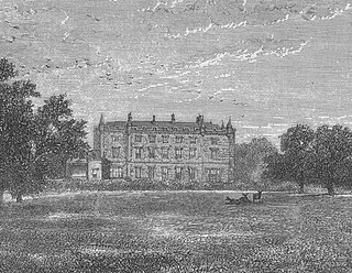
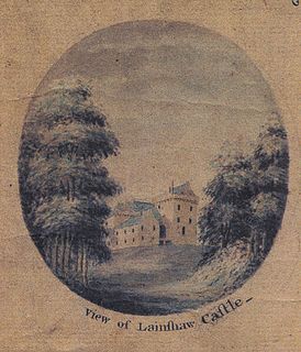
The Lands of Lainshaw lie in Strathannick and were part of the Lordship of Stewarton, in East Ayrshire, Scotland. Lainshaw House is a category B listed mansion, lying in a prominent position above the Annick Water and its holm in the Parish of Stewarton, Scotland. Part of the much older Lainshaw Castle is contained within the several later building phases of the present day Lainshaw House. The names 'Langshaw' or 'Langschaw' were used in historic times. Law Mount near the High and Laigh Castleton farms has been suggested as the site of the original castle, granted in the 12th century to Godfrey de Ross by Hugo de Morville.

Halket Loch

Halket Loch' also known as Halkhead or Halketh, was situated in the mid-Ayrshire clayland near Lugton. It is visible as a surface depression in pastureland, sometimes partially flooded, situated in a low-lying area close to farms and dwellings of East, North and Middle Halket and Craighead in the Parish of Dunlop, East Ayrshire, Scotland. The loch was natural, sitting in a hollow created by glaciation. The loch waters drained via the Glazert Water that joins the Annick Water.

Murder of Hugh Montgomerie

The Murder of Hugh Montgomerie, 4th Earl of Eglinton at the Annick Ford in Stewarton, East Ayrshire, Scotland, took place in 1586 as a consequence of a long running feud between the Montgomeries, Earls of Eglinton and the Cunninghames, Earls of Glencairn, families who were competing for power and influence locally and nationally. The significant repercussions of this act were felt throughout the county of Ayrshire and beyond. The spelling 'Montgomerie' is used throughout for both the family and Montgomery for the clan and clan and district names 'Cunninghame' in the same fashion.

Lands of Tour and Kirkland Human settlement in Scotland

The Lands of Tour and Kirkland (NS416406) formed a small estate close to the old Kirktoun and St Maurs-Glencairn collegiate church about 1 km south-east of Kilmaurs, East Ayrshire, Parish of Kilmaurs, Scotland. The word 'Tour' in Scots refers to a 'tower' and 'kirk' to a parish church.

Dalmusternock, East Ayrshire

Dalmusternock (NS455417) was a dower house built and occupied by William Mure after his marriage and prior to inheriting the family seat of Rowallan Castle. The property is located near Fenwick, in the Barony of Rowallan, lying 3 miles north of Kilmarnock and 18 miles south of Glasgow, Parish of Fenwick, East Ayrshire, Scotland. The estate is recorded as Dalmunsternoch circa 1654; Dalmasternock circa 1747; Dalmusterknok 1775

Lands of Borland Human settlement in Scotland

The Lands of Borland formed an estate lying between Aiket Castle and the town of Dunlop, East Ayrshire, Parish of Dunlop, Scotland. The laird's house at Borland stood near the Sandy Ford over the Glazert Water. The names Bordland, Boreland, Borland, Laigh Borland, Low Borland and Nether Borland have all been applied to the site of the laird's house.

Lands of Templehouse Human settlement in Scotland

The Lands of Templehouse formed a small estate lying between Aiket Castle and the town of Dunlop, East Ayrshire, Parish of Dunlop, Scotland. The laird's house at Templeland of Dunlop Hill, to give it its formal name, stood near to the ancient road leading from Dunlop to Kirkwood and on to Kennox. The lands were held by the Knights Templar until a date prior to 1570 when the Gemmells of Templehouse were granted the property and remained there until 1962, a period of around 500 years. The spelling 'Gemmell' is used for consistency except where otherwise denoted.

Lands of Dallars Human settlement in Scotland

The Lands of Dallars or Auchenskeith (NS463337) form a small estate in East Ayrshire, Hurlford, Kilmarnock, Parish of Riccarton, Scotland. The present mansion house is mainly late 18th-century, located within a bend of the Cessnock Water on the site of older building/s. "Dullers or Dillers" was changed to "Auchenskeith" or "Auchinskeigh" (sic) as well as other variants and then the name reverted nearer to the original form as "Dollars" and then finally "Dallars". Dallars lies 3.25 km south of Hurlford.

Lands of Blacklaw Human settlement in Scotland

The Lands of Blacklaw formed a small property of five merks worth, in the Lordship of Stewarton at the eastern extremity of Strathannick, between the hamlet of Kingsford in East Ayrshire and the East Renfrewshire boundary, Scotland. It was first recorded in 1484 in the Acta Auditorum. Black Law is a prominent whinstone crag lying above Blacklaw Hill Farm.

References

  1. 1 2 3 4 "Dictionary of the Scots Language" . Retrieved 10 January 2018.
  2. 1 2 Dobie, James D. (ed Dobie, J.S.) (1876). Cunninghame, Topographized by Timothy Pont 1604–1608, with continuations and illustrative notices. Pub. John Tweed, Glasgow. p. 381.
  3. "The Jersey Datestones Project: Introduction".
  4. "Galway Civic Trust - Marriage Stones" (PDF). Retrieved 10 January 2018.
  5. 1 2 3 McKean, Charles (2001). The Scottish Chateau. The Country house of Renaissance Scotland. Sutton Publishing. ISBN   0-7509-2323-7. p. 12.
  6. "Galway Civic Trust - Marriage Stones" (PDF). Retrieved 10 January 2018.
  7. MacDonald, Ian (2006). Oral communication to Griffith, Roger S. Ll.
  8. Dobie, James D. (ed Dobie, J.S.) (1876). Cunninghame, Topographized by Timothy Pont 1604–1608, with continuations and illustrative notices. Pub. John Tweed, Glasgow. pp. 98–99.
  9. Way, George and Squire, Romily. (1994). Collins Scottish Clan & Family Encyclopedia. (Foreword by The Rt Hon. The Earl of Elgin KT, Convenor, The Standing Council of Scottish Chiefs). pp. 272–273.
  10. Dobie, James. (1876) Cuninghame Topographized by Timothy Pont. Pub. John Tweed, Glasgow. Facing p. 366.
  11. This is not a marriage stone, but a datestone indicating the date when work was undertaken on the property. The full inscription on the stone is J.BS (entwined hearts) B.LGL 1884, inscribed for Jean Bisson and Betsey Le Gresley, who lived at Penryn Farm in 1884 but were actually married 30 years earlier. Few, if any, Jersey datestones can be identified as recording the dates marriages, as opposed to an event in the life of the property where they were erected. The Jersey Datestone Register - https://members.societe-jersiaise.org/alexgle/stonejsy.html - has so far identified over 1,700 datestones in the island and deciphered the majority of the inscriptions
  12. Michael Kaufman, Ritual and Custom - Chuppah, My Jewish learning
  13. Paul Gwynne (7 September 2011). World Religions in Practice: A Comparative Introduction. John Wiley & Sons. pp. RA5–PT49. ISBN   978-1-4443-6005-9.