
Nettlehirst or Nettlehurst was a small mansion house (NS365504) and estate in the Parish of Beith, near Barrmill in North Ayrshire, Scotland. The house was built in 1844 and burned down in 1932.
Nettlehirst or Nettlehurst was a small mansion house (NS365504) and estate in the Parish of Beith, near Barrmill in North Ayrshire, Scotland. The house was built in 1844 and burned down in 1932.
The 1856 OS map shows an L-shaped building at the site of the later 'castle' with a detached outbuilding nearby and a saw pit close to the house. A Nettlehirst Townhead is marked nearby, lying to the north-west of the house. Few trees are indicated and the mausoleum was not yet built. A driveway led down to the road with a 'lodge-like' building at the entrance. No grooms cottage existed at that time. [1] The 1895 OS shows the groom's cottage and stables, a much larger house, extensive tree planting, but no lodge house, outbuildings or sawpit. Nettlehirst Townhead is not named as such however the building is marked, somewhat enlarged and now L-shaped. A burial ground is shown at the end of a long path. A footpath runs from the house area down to Giffen Station. [2] In 1902 a footpath connected the burial ground directly to Giffen Station and the road to South Barr and Gatend. The Nettlehirst Mains buildings are smaller and partly roofless. [3]


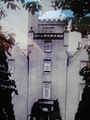
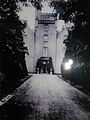
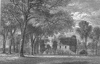
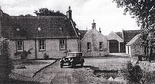
This was at its peak a fine mansion, somewhat eccentric in its architecture, also written as 'Nettlehurst', a castle-like structure with 16 rooms, situated on the high ground above the old limekilns, overlooking the Giffen Station, Giffen Viaduct, Barrmill and the Dusk Water. It had a five-storey central tower and was surrounded by three-storey crow-stepped wings. [4] The Burns family built Nettlehirst House in 1844. [5]
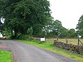
Davis sees the house as being an enlargement of a pre-existing house and attributes the style to lack of finance and amateurish design. The unusual gate-piers, one is taller than the other, still look onto the former groom's cottage. [6] Other buildings nearby were the homefarm and accommodation associated with the limekilns. The surviving ruin with the marriage stone may have been related to the quarry workings after the castle was demolished. It contains a concrete slab with steel rods for attaching a generator or such like.
In July 1932 the house burned down, possibly due to an electrical fire, as mains power was not installed in the district until circa 1935 however the house possessed its own generator. The dramatic fire coincided with the return from South Beach by a special train of Barrmill Sunday School trip on the line from Ardrossan to Giffen Station. Passengers climbed up and watched the fire from the quarry area. The fierce fire was clearly visible from the train and it was a talking point in the village for months. The Kerr family moved to "Drumrossie" in Beith.
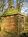
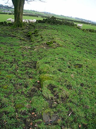
The mansion house was never restored and shortly afterwards most of the dangerous ruin was demolished. The unusual entrance gatepiers, apple and pear orchard, boundary walls, mausoleum, farm and the stables, with its crow stepped gable ends and an 1811 marriage stone remain. The platform of the old tennis court is still apparent. [7] The old drawing illustrated here shows that the area was heavily planted with trees, especially yews that were felled for their timber.
The OS Map shows a family burial ground located near woodland to the south of the old house site. The fine red sandstone structure still survives (2010) although the crypt is said to have been broken into during WW2 by soldiers 'looking for treasure' and the frontage stones are much disturbed. A further report indicates that the damage may have been caused by cattle. No inscriptions are apparent on the structure. The burial site is said to have been in front of the mausoleum, within the skirting wall and railings.


In 1804, Captain John Fulton of Grangehill married Catherine MacLellan, only daughter of the Rev. David Maclellan of Nettlehurst, Minister of Beith. They had two offspring, namely John and Isabella Fulton. Isabella married the Rev. Robert Crawford of Irongray. John's son was William Patrick Fulton. [8] David Maclellan wrote articles under the name 'Urtica' (The scientific binomial for a stinging nettle is Urtica dioica ). William Patrick of Roughwood obtained Nettlehirst from the Fultons and it later became part of the Giffin House estate. [9]
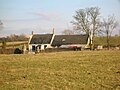
William Burns, a shoemaker from Drumbuie, obtained Townhead of Nettlehirst in the 18th century and his sons Robert and James inherited it in turn; Robert having no heirs. William Burns, son of James, inherited it in 1845. William had three sons, James, William and David. [9]


James Brown, Writer in Beith, was the son of Hugh Brown of Broadstone and is recorded as 'James of Nettlehurst'. James married Janet, daughter of James Finlay of Easter Highgate, had a son Robert and died in 1855. [10]
William and Anne Burns lived at Nettlehirst in 1901 according to the Census, together with their sons Walter and Albert. William is recorded as being a merchant dealing in 'fancy goods', also a toy-maker.
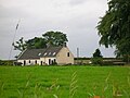
In 1915 it was sold to Mr Thomas Currie Kerr JP, at that time a well known ironmaster [11] and owner of the limeworks. Reid records that Thomas was an engineering contractor and together with his wife, Eliza. Jane Donaldson, owned William Kerr and Co (named in honour of his father). Kerr's were based at Mavisbank in Glasgow, and specialised in moving heavy loads, such as locomotives. Road Engines and Kerr Ltd was its name just prior to being taken over by Pickfords. [4] Izabel Kerr, daughter of Thomas Kerr, married Dr Ian F. Somerville, a Beith GP in 1932. [4] In 2011 it was the property of the Gillon's of nearby Shotts Farm.
The faint remains of ruined cottages are still visible on the lane from Greenhills to Nettlehirst and these were once weavers shops and the steading on the corner was known as 'Nanny Pringle's o'the Haghead'. [11]
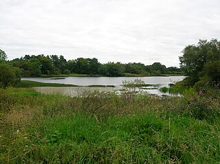
The Black Loch was a shallow loch situated near Nettlehirst House and it was once used for curling. The site was filled with earth and is now overgrown. [12]
John Kerr of Nettlehirst, son of Hugh Kerr of Gatend, gave £20 a year and established a Society for Clothing, Blankets, and Clothes for the poor. [13]
Daniel Montgomery is listed as a farmer at Nettlehirst in the 1850s and William Burns was resident at Nettlehirst House. [14]


A confusing number of properties in the area are known as Nettlehirst, some distinctions being made by adding 'cottage' or the owners name, such as Reid Nettlehirst. The origin of the placename itself is unknown; however, the 'Nettle' may refer to the plant and 'Hurst' may refer to harvest, meaning an area where nettles predominate. The term 'hairst' might refer to a barren hillock, knoll, or ridge. A fitting description of the site today. There was an old village called Nettlehirst which appears on old maps.

The old Barony and castle of Corsehill lay within the feudal Baillerie of Cunninghame, near Stewarton, now East Ayrshire, Scotland.

Lugton is a small village or hamlet in East Ayrshire, Scotland with a population of 80 people. The A736 road runs through on its way from Glasgow, 15 miles (24.1 km) to the north, to Irvine in North Ayrshire. Uplawmoor is the first settlement on this 'Lochlibo Road' to the north and Burnhouse is to the south. The settlement lies on the Lugton Water which forms the boundary between East Ayrshire and East Renfrewshire as well as that of the parishes of Dunlop and Beith.

Kerelaw Castle is a castle ruin. It is situated on the coast of North Ayrshire, Scotland in the town of Stevenston.
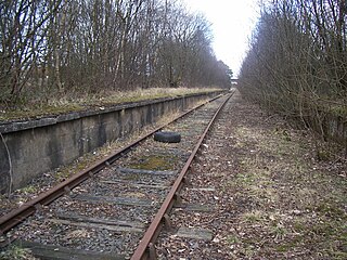
Giffen railway station was a railway station approximately one mile south-west of the village of Barrmill, North Ayrshire, Scotland. The station was part of the Lanarkshire and Ayrshire Railway.
Hessilhead is in Beith, North Ayrshire, Scotland. Hessilhead used to be called Hazlehead or Hasslehead. The lands were part of the Lordship of Giffen, and the Barony of Hessilhead, within the Baillerie of Cunninghame and the Parish of Beith. The castle was situated at grid reference NS380532.

The Barony of Giffen and its associated 15th-century castle were in the parish of Beith in the former District of Cunninghame, now North Ayrshire. The site may be spelled Giffen or Giffin and lay within the Lordship of Giffin, which included the Baronies of Giffen, Trearne, Hessilhead, Broadstone, Roughwood and Ramshead; valued at £3,788 9s 10d. The Barony of Giffen comprised a number of properties, including Greenhills, Thirdpart, Drumbuie, Nettlehirst and Balgray, covering about half of the parish of Beith. Giffen was a hundred merk land, separated from the Barony of Beith, a forty-pound land, by the Powgree Burn which rises on Cuff hill. The Lugton Water or the Bungle Burn running through Burnhouse may have been the Giffen barony boundary with that of the adjacent barony and lands of Aiket castle.

Gateside is a small village in North Ayrshire, Scotland about 1⁄2 mile east of Beith on the B777.

Barrmill is a small village in North Ayrshire, Scotland about 1+1⁄2 miles east of Beith on the road to Burnhouse and Lugton. Locally it is known as the Barr.

Spier's School (NS352533), at Beith, in North Ayrshire, Scotland was opened in 1888 and closed in 1972. The school, now demolished, was built using Ballochmyle red sandstone and was reminiscent of the ancient Glasgow University. The school motto was 'Quod verum tutum'. The gardens and woodlands are open to the public at all times.

Broadstone lies close to the small village of Gateside in North Ayrshire, Scotland about half a mile east of Beith in the old Barony of Giffen.
The old Barony and castle, fortalice, or tower house of Hill of Beith lay in the feudal Regality of Kilwinning, within the Baillerie of Cunninghame, and the Sherrifdom of Ayr, now the Parish of Beith, North Ayrshire, Scotland.

Lowes Loch, The Lochs or Loch of Hill is now a small natural freshwater loch in the North Ayrshire Council Areas, Scotland, lying in a glacial kettle hole, once of greater extent, lying below Brownmuir and Lochland Hills on the Threepwood Road, near Beith, in the Parish of Beith. The loch may once have had a small island within it.

Barkip, also known as The Den, is a hamlet in North Ayrshire, Scotland about three miles southwest of Beith on the A737 road to Dalry. The earliest recorded name is 'Blairkip'. In the Gaelic language, the name Barkip comes from bar ("top"), and kip. It is not clear when or why the name 'The Den' started to be used although it appears in the local press as both in 1898, however in Scots as in old English one meaning is 'A hollow between hills,' which is certainly an accurate description of the geography of the area that Barkip lies in. Following construction of a new road, Barkip no longer sits on the main Beith to Dalry road.
Bogston or later Bogstone was a small estate in the old Barony of Giffen near Barrmill in the Parish of Beith, North Ayrshire, once held by collateral descendants of the Montgomeries of Broadstone. The estate covered 160 acres or around 65 hectares, its rental in 1896 being £180 per annum.

Burnhouse, sometimes known locally as The Trap from "Man Trap", is a small village or hamlet in North Ayrshire, Parish of Beith, Scotland. It lies on a crossroads of old B706 and the more recent A736 Lochlibo Road, between Lugton and Torranyard.

Roughwood once Ruchwood is a farm, originally a estate, possessing at one time a small tower castle. Roughwood is situated near to the town of Beith in North Ayrshire, Scotland; the lands lay within the old Lordship of Giffen.
Greenhills is a small village or hamlet in North Ayrshire, Parish of Beith, Scotland. It lies between the settlements of Barrmill and the hamlet of Burnhouse on a crossroads of the B706 and the lanes to Nettlehirst and Tandlehill via the Third part. It is named after the 'Green Hill' an artificial mound, a Moot, Law or Justice hill that once stood here. The settlement lay within the old Barony of Giffen; the castle no longer exists. The village lies within Barrmill and District Community Association's area and is also covered by Beith Community Council.

The lands of Marshalland, Marsheland, Marsheyland or Marshyland were part of the holdings of the Barony of Beith, Regality of Kilwinning and Bailiary of Cuninghame. They became the property of the Lyle family, then the Shedden family, passing next to the Spier's family before finally becoming part of the Spier's Trust lands. The laird's house and farm were demolished in the 1960s.

The lands of Morishill,Morrishill,Moorishill or Moricehill were part of the holdings of the Barony of Beith, Regality of Kilwinning and Bailiary of Cuninghame. The name may have derived from large shielings or huts that were once erected at the site.
The lands of Threepwood were located in the Parish of Beith, at the eastern boundary between East Renfrewshire and North Ayrshire, Scotland. The settlements of Midtown, Townhead and Townend were part of the old Threepwood Estate. Cuffhill at 675 feet is the highest eminence in the parish and it overlooks the area with Little Hill and Cuff Hill and Little Hill plantations nearby, now situated next to the entirely artificial Cuffhill Reservoir.