Giffordland

Last updated • 6 min readFrom Wikipedia, The Free Encyclopedia

Giffordland
Barony
Giffordland House.JPG
Giffordland Farmhouse with 'Crow steps' on the gable ends
Map of Dunduff castle & roads.jpg
William Aiton's map of Ayrshire showing 'Gifford' [2]
CountryUnited Kingdom
CountyNorth Ayrshire
RegionStrathclyde
ParishDalry

55°42′07″N4°45′04″W / 55.702°N 4.751°W / 55.702; -4.751

Contents

Giffordland is in North Ayrshire, Parish of Dalry (Cunninghame) in the former Region of Strathclyde, Scotland.

Background

Giffordland was a small barony, but the families associated with it played an active part in the history of feudal Scotland.

The name is given as just 'Gifford' on Armstrong's 1775 map [3] and Ainslie's 1821 map [4] and as 'Giffertland Mains' on the first 6 inch OS maps of 1840 - 1880. A Giffordland Mill, originally with stepping stones and now a bridge, lie at the Caaf Water (Keaff in 1747 [5] ); a smithy lay close to the Caaf Water near the Dalry to West Kilbride Road. A limekiln were located near to the 'Mains' farm buildings. A ford existed over the Auldmuir Burn until the late 19th century.

The Auldmuir Burn runs through a deeply cut glen which has been planted up with beech trees in the vicinity of Giffordland Farm. A small building sat close to the junction of the road to Auldmuir, and a building known as 'Green House' is marked as a ruin in the 1840–1880 Ordnance Survey map and an active settlement on Roy's map of 1747. [5]

History

A semi-natural 'Moot Hill' in the glen with old beech trees and the Auldmuir Burn Giffordland Moot.JPG
A semi-natural 'Moot Hill' in the glen with old beech trees and the Auldmuir Burn

The Barony of Giffordland included the estate of Auldmuir, including the one merk land of Wardlaw and Bradshaw. Paterson describes Gifford as being a mansion house set on the banks of a rivulet (the Auldmuir Burn) about two miles West of Dalry, small in dimensions, but surrounded by old woods. [6] George Robertson gives the same account, but states in the 1820s that it was not in the best of order.. Its rental value at the time was £123 6s 8d. [7] The Barony would have had a Moot hill and the small mound in the Giffordland Glen shows signs of having been artificially altered (see illustration). Giffordland had also been known as Netherton. [8]

The Giffords

Gifford or Giffordland takes its name from the Giffords or Giffards, a Norman family who under King William the Lion (1165–1214) obtained lands in Scotland, such as the Parish of Yester in the Lothians near Haddington. The male line failed with Sir Hugh Gifford who had four daughters and died in 1409. [9] Robertson relates that Sir Thomas Boyd of Kilmarnock married Alice, one of these four daughter co-heiresses, but he does not actually record any relationship with the Craufurds of Kilmarnock, progenitors of the Gifford cadet branch at just this time. [10] A village named Gifford is located near the old Yester Castle of the Gifford's in East Lothian.

The Craufurds

Yester or Garvald Castle in East Lothian; once held by the Gifford family Garvald or Yester Tower, 1814.jpg
Yester or Garvald Castle in East Lothian; once held by the Gifford family

The Craufurds of Giffordland were cadets of the house of Craufurdland. John was the first of the line, son of John Craufurd of Craufurdland and living in 1440 was succeeded by his son John in 1480. Andrew Craufurd of Giffordland was killed at Flodden in 1513 and in 1547 John Craufurd was killed at the battle of Pinkie, having married twice, once to the daughter of the Laird of Kelburne; and secondly to the daughter of the Laird of Hunterston. [11] The Craufurds of Birkheid were cadets of Giffordland. [12] In 1543 John Craufurd of Giffordland and John Craufurd of Birkheid were found to have failed to support Mary Queen of Scots at the Siege of Coldingham during the troubles linked to King Henry VIII of England's attempts to persuade the Scottish Queen to marry his son, Prince Edward. [13] John Craufurd obtained a grant of the lands of Giffordland from James VI under the Great Seal on 27 March 1576. His wife was Margaret Blair daughter of John Blair of that Ilk. He died in 1583. [14]

At the Castle of Blair on May 3, 1595, Margaret Craufurd and her husband Thomas Craufurd of Giffordland granted their eldest daughter, Grizel and her husband, John Blair of Windyedge, a third part of the Three pound land of Giffordland. At a later stage they also gave the lands of Bradshaw (Broadshaw) and Knockendon. It is recorded that Margaret Craufurd could not write and it is clear from the original parchment that the notary had to guide her hand. [10] From this marriage the Blairs of Giffordland were descended. [15]

Isabel Craufurd, Grizel's sister, married John Craufurd of Walston and had been retoured a portion of the Giffordland lands in 1548; their son John died in France. Thomas Craufurd of Walston, their direct descendant, is recorded as a portioner of Giffordland after 1600 and he married a daughter of the Laird of Craufurdland. [16] Alexander Blair of Giffordland married Jeane Broun of Burrowland in the early 17th century and had two sons, Alexander and John; Alexander inherited Giffordland. [17]

The Craufurds, as lairds of Giffordland, maintained a town house in Irvine. A 1499 inventory records that the house contained two dinner tables, five benches, kitchen equipment, three storage chests, five beds with bedding, and pillows, an iron chimney and tongs. [18]

The Boyds and Blairs

In 1577 Isabella and Margaret Craufurd, daughters of the deceased John Craufurd of Giffertland, with the agreement of their husbands (John Craufurd and Thomas Craufurd), agreed to the resignation of the three pound lands of Mains of Giffertland or Nethertoun, with the manor-place, etc to Robert, Lord Boyd. The two and a half merk lands of Birkatt; six merk lands of Braidschaw; and two merk lands of Knockindone, also in the Lordship of Giffertland were in addition resigned. John Blair obtained the Superiority of Birkatt. [19]

In 1614 Robert Lord Boyd inherited 'Giffertland' from his father, Robert, Master of Boyd. [6] [20] Alexander Blair inherited the lands from his father in 1634, confirmed by the Superior, Lord Boyd, in 1641. He married a Jean Brown of Burrowland and his second son, John, became Laird of Burrowland. The line continued and William Blair married an English Lady, having two sons, the eldest of whom, Edward, was a ward of Chancery due to a commission of lunacy and the youngest therefore became proprietor. [6] William Dobie states that the younger brother died in London and Edward was therefore the end of the direct male line. [21] Alexander Blaire of Giffartland (sic) paid £18 4s 02d feu deuty in 1666 for his lands of Barow Landis (sic) and others pertaining to him. [22]

The Morrises

The estate of Auldmuir, including the one merk land of Wardlaw is recorded as having been owned in 1807 by Robert Morris of Craig in Kilmaurs parish, whose son, Hugh Baxter Morris also inherited Auldmuir and the Wardlaws. [23]

Thirdpart farm

The farm of this name appears to have its origin in the marriage settlement or dowry of Grizel Craufurd in 1595. [15]

Giffordland Glen

Natural history

Giffordland Glen is a provisional Wildlife Site, listed as such by the Scottish Wildlife Trust due to its old woodlands and biodiversity.

See also

Related Research Articles

<span class="mw-page-title-main">Bourtreehill House</span>

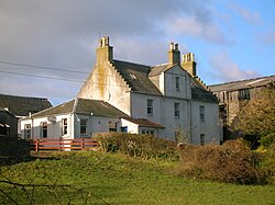
Bourtreehill House and the enclosed land on which it was built form the original estate of Bourtreehill. The wooded hill-top, a distinctive feature of the estate, is now a landmark that sits at the centre of modern North Bourtreehill in the district of North Ayrshire on the west coast of Scotland.

<span class="mw-page-title-main">Kerelaw Castle</span> Ruin castle in Scotland

Kerelaw Castle is a castle ruin. It is situated on the coast of North Ayrshire, Scotland in the town of Stevenston.

<span class="mw-page-title-main">Hessilhead</span> Area in North Ayrshire, Scotland

Hessilhead is in Beith, North Ayrshire, Scotland. Hessilhead used to be called Hazlehead or Hasslehead. The lands were part of the Lordship of Giffen, and the Barony of Hessilhead, within the Baillerie of Cunninghame and the Parish of Beith. The castle was situated at grid reference NS380532.

<span class="mw-page-title-main">Barony and Castle of Giffen</span> Barony in the former District of Cunninghame, now North Ayrshire

The Barony of Giffen and its associated 15th-century castle were in the parish of Beith in the former District of Cunninghame, now North Ayrshire. The site may be spelled Giffen or Giffin and lay within the Lordship of Giffin, which included the Baronies of Giffen, Trearne, Hessilhead, Broadstone, Roughwood and Ramshead; valued at £3,788 9s 10d. The Barony of Giffen comprised a number of properties, including Greenhills, Thirdpart, Drumbuie, Nettlehirst and Balgray, covering about half of the parish of Beith. Giffen was a hundred merk land, separated from the Barony of Beith, a forty-pound land, by the Powgree Burn which rises on Cuff hill. The Lugton Water or the Bungle Burn running through Burnhouse may have been the Giffen barony boundary with that of the adjacent barony and lands of Aiket castle.

Fergushill is a small community in North Ayrshire, Parish of Kilwinning, Scotland. The Barony of Fergushill was held by the Fergushill family of that Ilk and the area has a complex history.

<span class="mw-page-title-main">Barony of Bonshaw</span> Barony in North Ayrshire, Scotland

The Barony of Bonshaw, previously known as Bollingshaw, was in the old feudal Baillerie of Cunninghame, near Stewarton in what is now North Ayrshire, Scotland.

<span class="mw-page-title-main">Busbie Castle</span>

Busbie Castle was situated in what is now known as Knockentiber, a village in East Ayrshire, Parish of Kilmaurs, Scotland. Knockentiber is 2 miles (3.2 km) WNW of Kilmarnock and 1/2 mile NE of Crosshouse. The castle overlooked the Carmel Glen and its Burn, which runs into the River Irvine, a mile or so to the south, after passing through the old Busbie Mill.

<span class="mw-page-title-main">Barony of Ladyland</span> Former barony in North Ayrshire, Scotland

The Barony of Ladyland was in the old feudal Baillerie of Cunninghame, near Kilbirnie in what is now North Ayrshire, Scotland.

<span class="mw-page-title-main">Castle and Barony of Robertland</span> Place in East Ayrshire, Scotland

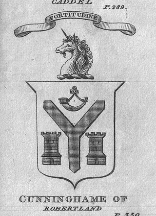
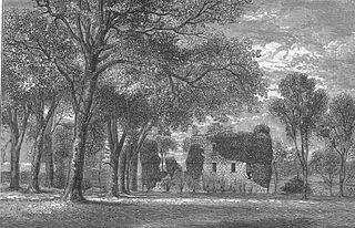
The Castle and Barony of Robertland is located near Stewarton, off the B769 road, in the old district of Cunninghame, Parish of Stewarton, and now part of East Ayrshire, Scotland.

<span class="mw-page-title-main">The Lands of Pitcon</span>

The Lands of Pitcon, previously Potconnel now form a small estate of around 100 acres in the Parish of Dalry, North Ayrshire in the old Barony of Dalry. The present category B listed Georgian mansion house dating from 1787, replaces an older castellated dwelling. Pitcon lies on the outskirts of Drakemyres, now a suburb of Dalry, close to the confluence of the Rye Water, River Garnock, and the Mains Burn, standing on a low knoll. Such a marshy area would have provided a degree of protection to the old castle.

<span class="mw-page-title-main">Polkelly Castle</span>

Polkelly Castle, also Pokelly, was an ancient castle located near Fenwick, at NS 4568 4524, in the medieval free Barony of Polkelly, lying north of Kilmarnock, Parish of Fenwick, East Ayrshire, Scotland. The castle is recorded as Powkelly (c1747), Pockelly (c1775), Pow-Kaillie, Ponekell, Polnekel, Pollockelly, Pollockellie, Pokellie, Pothelly, Pathelly Ha' and Polkelly. The name is given circa 1564 as Powkellie when it was held by the Cunninghams of Cunninghamhead.

<span class="mw-page-title-main">Barony of Kersland</span>

The remains of the old castle of Kersland lie about 1.5 miles to the north-east of the town of Dalry in North Ayrshire, Scotland, in the old Barony of Kersland. The River Garnock lies nearby.

Swindridgemuir House and estate were composed of the 'Lands of Swindridgemuir' and the dwelling house about two miles north-east of Dalry in the old Barony of Kersland, about a mile and a half north of the Blair Estate, North Ayrshire, Scotland. The spelling on the family memorials at Ayr Auld Kirk is 'Swindrigemuir'.

<span class="mw-page-title-main">Lands of Marshalland</span>

The lands of Marshalland, Marsheland, Marsheyland or Marshyland were part of the holdings of the Barony of Beith, Regality of Kilwinning and Bailiary of Cuninghame. They became the property of the Lyle family, then the Shedden family, passing next to the Spier's family before finally becoming part of the Spier's Trust lands. The laird's house and farm were demolished in the 1960s.

<span class="mw-page-title-main">Towerlands, North Ayrshire</span> Human settlement in Scotland

Towerlands or Tourlands was a small estate of 70 to 80 acres of good quality land in the parish of Irvine and the old barony of Kilmaurs, North Ayrshire, Scotland, situated near the more extensive property of Bourtreehill, the lands of which surrounded it on three sides. The name suggests that a medieval stone or wood 'tower' structure of some sort existed, but no record of this appears to exist.

The lands of Broomlands or Broumlands formed a small country estate about a mile to the east of Irvine, North Ayrshire, Scotland situated on the east bank of the Annick Water in the Parishes of Dreghorn and Irvine.

<span class="mw-page-title-main">Fairlie Castle</span> Castle in North Ayrshire, Scotland, UK

Fairlie Castle is a restored oblong tower castle located on a natural rounded knoll situated above a precipitous section of the Fairlie Glen near the town of Fairlie in the old Barony of Fairlie, Parish of Largs, North Ayrshire, Scotland. It was built by the now extinct family, the Fairlies of that Ilk and survives in a fairly good state of preservation. It is a protected scheduled monument.

<span class="mw-page-title-main">Soulis Cross</span>

The ancient Soulis Cross was originally located in the centre of Soulis Street (NS43013821) near the Kilmarnock Water in Kilmarnock, East Ayrshire, Scotland. In 1825 a replacement cross in the form of a fluted pillar topped with an urn was erected using funds raised by public inscription and this was placed near the original site but located in an alcove situated within the high boundary wall of the High Kirk (NS43003820). A brass diamond mark was placed in the road to indicate the original site where Lord Soulis is said to have died, but this is no longer visible as it has become covered with tarmac.

The Lands of Dallars or Auchenskeith (NS463337) form a small estate in East Ayrshire, Hurlford, Kilmarnock, Parish of Riccarton, Scotland. The present mansion house is mainly late 18th-century, located within a bend of the Cessnock Water on the site of older building/s. "Dullers or Dillers" was changed to "Auchenskeith" or "Auchinskeigh" (sic) as well as other variants and then the name reverted nearer to the original form as "Dollars" and then finally "Dallars". Dallars lies 3.25 km south of Hurlford.

<span class="mw-page-title-main">Lands of Blacklaw</span> Human settlement in Scotland

The Lands of Blacklaw formed a small property of five merks worth, in the Lordship of Stewarton at the eastern extremity of Strathannick, between the hamlet of Kingsford in East Ayrshire and the East Renfrewshire boundary, Scotland. It was first recorded in 1484 in the Acta Auditorum. Black Law is a prominent whinstone crag lying above Blacklaw Hill Farm.

References

  1. Aiton, William (1811). General View of the Agriculture of the County of Ayr. Glasgow.
  2. Aiton, William (1811). General View of the Agriculture of the County of Ayr. Glasgow.
  3. Andrew Armstrong's map. Archived 2009-03-04 at the Wayback Machine
  4. "John Ainslie's 1821 map". Archived from the original on 26 February 2009. Retrieved 3 November 2008.
  5. 1 2 Roy's Military Survey of Scotland 1747-55
  6. 1 2 3 Paterson, James (1866), History of the Counties of Ayr and Wigton. Vol.III. - Cunninghame. Part 1. Pub. James Stillie, Edinburgh. P. 175–6.
  7. Robertson, George (1823), A Genealogical Account of the Principal Families in Ayrshire, more particularly in Cunninghame. Vol.1. Pub. Cunninghmae press, Irvine. P. 102.
  8. Thomas, Lord Boyd's lands.
  9. Groome, Francis H. (1903), Ordnance Gazetteer of Scotland. Pub. Caxton Publishing, London. P. 646.
  10. 1 2 Robertson, George (1823), A Genealogical Account of the Principal Families in Ayrshire, more particularly in Cunninghame. Vol.1. Pub. Cunninghmae press, Irvine. P. 105.
  11. Paterson, James (1866), History of the Counties of Ayr and Wigton. Vol.III. - Cunninghame. Part 1. Pub. James Stillie, Edinburgh. P. 177.
  12. George Robertson (1823). A genealogical account of the principal families in Ayrshire, more particulary[sic] in Cunninghame. pp.  213.
  13. Paterson, James (1866), History of the Counties of Ayr and Wigton. V. III. - Cunninghame. Part 1. Edinburgh : James Stillie. P. 31 - 32.
  14. Burke, John (1836), A Genealogical and Heraldic History of the Commoners of Great Britain and Ireland. P. 233.
  15. 1 2 Dobie, James D. (ed Dobie, J.S.) (1876). Cunninghame, Topographized by Timothy Pont 1604–1608, with continuations and illustrative notices. Pub. John Tweed, Glasgow. P. 49.
  16. Robertson, George (1823), A Genealogical Account of the Principal Families in Ayrshire, more particularly in Cunninghame. Vol.1. Pub. Cunninghmae press, Irvine. P. 216.
  17. Kilwinning Past and Present. Kilwinning & District Preservation Society. Section 3, Page 3.3
  18. Strawhorn, Page 18
  19. Archaeological & Historical Collections relating to the counties of Ayrshire & Wigtown. Edinburgh : Ayr Wig Arch Soc. 1882, Page 207
  20. Dobie, James D. (ed Dobie, J.S.) (1876). Cunninghame, Topographized by Timothy Pont 1604–1608, with continuations and illustrative notices. Pub. John Tweed, Glasgow. P. 388.
  21. Robertson, George (1823), A Genealogical Account of the Principal Families in Ayrshire, more particularly in Cunninghame. Vol.1. Pub. Cunninghame press, Irvine. P. 102. Annotated copy by William Dobie.
  22. Muniments of the Royal Burgh of Irvine. Ayrshire & Galloway Archaeological Association. 1891. P. 187
  23. Dobie, James D. (ed Dobie, J.S.) (1876). Cunninghame, Topographized by Timothy Pont 1604–1608, with continuations and illustrative notices. Pub. John Tweed, Glasgow. P. 388.