
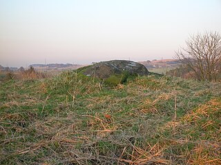
A chambered cairn is a burial monument, usually constructed during the Neolithic, consisting of a sizeable chamber around and over which a cairn of stones was constructed. Some chambered cairns are also passage-graves. They are found throughout Britain and Ireland, with the largest number in Scotland.

Kintyre is a peninsula in western Scotland, in the southwest of Argyll and Bute. The peninsula stretches about 30 miles (48 km), from the Mull of Kintyre in the south to East Loch Tarbert in the north. The area immediately north of Kintyre is known as Knapdale.

Cairnpapple Hill is a hill with a dominating position in central lowland Scotland with views from coast to coast. It was used and re-used as a major ritual site over about 4000 years, and in its day would have been comparable to better known sites like the Standing Stones of Stenness. The summit lies 312 m above sea level, and is about 2 miles (3 km) north of Bathgate. In the 19th century the site was completely concealed by trees, then in 1947–1948 excavations by Stuart Piggott found a series of ritual monuments from successive prehistoric periods. In 1998, Gordon Barclay re-interpreted the site for Historic Scotland. It is designated a scheduled ancient monument.

New Luce is a civil parish in Dumfries and Galloway, south-west Scotland. It lies in the traditional county of Wigtownshire, and is about 10 miles (16 km) in length and 5 miles (8.0 km) in breath, being the upper part of the original Glenluce Parish. New Luce is shown as a civil parish on John Ainslie's county map of 1782.
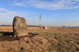
There are many large stones of Scotland of cultural and historical interest, notably the distinctive Pictish stones, but also the other types discussed below.

Clach an Trushal is said to be the tallest standing stone in Scotland. Above ground it stands approximately 5.8 metres tall, is 1.83 m wide and at its thickest point is 1.5 m thick, with a girth at its base of 4.75 m. The stone is sited in the village of Ballantrushal on the west side of Lewis. Local legend says that it marks the site of a great battle, the last to be fought between the feuding clans of the Macaulays and Morrisons. However it is actually the solitary upright stone remaining from a stone circle built about 5,000 years ago. It occupied a place within the circle, although its placement was not central. The second last standing stone was removed in 1914, and used as a lintel.
Mochrum is a coastal civil and Church of Scotland parish situated to the east of Luce Bay on the Machars peninsula and 8 miles (13 km) southwest of Wigtown and in the historical county of Wigtownshire in Galloway, Scotland. It covers 22,000 acres (8,900 ha) and is approximately 10 miles (16 km) in length and 5 miles (8.0 km) in breadth. The parish contains the eponymous village of Mochrum, as well as Port William and the clachan of Elrig.
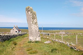
Ballantrushal is a village on the Isle of Lewis in the West Side district, in the Outer Hebrides, Scotland. Ballantrushal is within the parish of Barvas, and is situated on the A857. The standing stone Clach an Trushal is beside the village. and was the site of the last battle between the Lewis Macaulays and Morrison clans.
Carlin Stone or Carlin Stane is the name given to a number of prehistoric standing stones and natural stone or landscape features in Scotland. The significance of the name is unclear, other than its association with old hags, witches, and the legends of the Cailleach.

Easter Aquhorthies stone circle, located near Inverurie in north-east Scotland, is one of the best-preserved examples of a recumbent stone circle, and one of the few that still have their full complement of stones and the only one that has all its stones still standing without having been re-erected. It stands on a gentle hill slope about 1 mile (1.6 km) west of Inverurie, and consists of a ring of nine stones, eight of which are grey granite and one red jasper. Two more grey granite stones flank a recumbent of red granite flecked with crystals and lines of quartz. The circle is particularly notable for its builders' use of polychromy in the stones, with the reddish ones situated on the SSW side and the grey ones opposite. The discovery of a possible cist covered by a capstone at the centre of the circle indicates that there may once have been a cairn there, but only a conspicuous bump now remains.

The Barony of Ladyland was in the old feudal Baillerie of Cunninghame, near Kilbirnie in what is now North Ayrshire, Scotland.
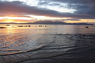
The Isle of Arran or simply Arran is an island off the west coast of Scotland. It is the largest island in the Firth of Clyde and the seventh largest Scottish island, at 432 square kilometres (167 sq mi). Historically part of Buteshire, it is in the unitary council area of North Ayrshire. In the 2011 census it had a resident population of 4,629. Though culturally and physically similar to the Hebrides, it is separated from them by the Kintyre peninsula. Often referred to as "Scotland in Miniature", the island is divided into highland and lowland areas by the Highland Boundary Fault and has been described as a "geologist's paradise".

Machrie Moor Stone Circles is the collective name for six stone circles visible on Machrie Moor near the settlement of Machrie on the Isle of Arran, Scotland.
The Cat Stane, or Catstane, is an inscribed standing stone near Kirkliston, on the outskirts of Edinburgh, in Scotland. It bears a fragmentary inscription dating to the fifth or sixth centuries and was part of a funerary complex consisting of the stone itself, a cairn and a series of cist burials.
Old Luce is a civil parish in Dumfries and Galloway, Scotland. It lies in the Machars peninsula, in the traditional county of Wigtownshire. The parish is around 10 miles (16 km) long and 8 miles (13 km) broad, and contains 40,350 acres (16,330 ha).

Auchagallon Stone Circle or Auchengallon cairn is the remains of a Neolithic or Bronze Age burial cairn, surrounded by a circle of fifteen stones. It is located near Machrie on the Isle of Arran in Scotland.
Craigie is a small village and parish of 6,579 acres or 2,662 hectares in the old district of Kyle, now South Ayrshire, 4 miles (6 km) south of Kilmarnock, Scotland. This is mainly a farming district, lacking in woodland, with a low population density, and only one village. In the 19th century, high quality lime was quarried here with at least three sites in use in 1832.

Lendalfoot is a small village located on Carleton Bay, parish of Colmonell in the old district of Carrick, now South Ayrshire, about 6 miles (9.7 km) south of Girvan, Scotland. This is mainly a farming district, lacking in woodland, with a low population density. The village sits astride the A77 that runs north to Girvan and south to Cairnryan and Stranraer. Carleton Hill rises to 520 feet or 158 metres from the road and is the site near its summit of earth banks, an ancient fort.

Lawthorn is a hamlet near Perceton in Strathannick, Irvine, North Ayrshire, Scotland. The settlement lies on the old Irvine to Stewarton toll road.

Kemp Law Dun is a vitrified fort dating from the Iron Age situated near the town of Dundonald in South Ayrshire, Scotland. The remains of the Iron Age fort or dun lie on the old Auchans Estate in the Dundonald Woods near the site of the old Hallyards Farm and the quarry of that name. The footpath route known as the Smugglers' Trail through the Clavin Hills from Troon to Dundonald runs passed the ruins of the dun. Kemps Law is in the order of two thousand years old.


