The Holy Cave, Hunterston

Last updated

The Holy Cave
Hawking Craig Cave
The Holy Cave's entrance from the north, Hawking Craig Wood, Hunterston, North Ayrshire.jpg
The opening to the Holy Cave
Location Hunterston, North Ayrshire
OS grid NS 1794 5079
Coordinates 55°42′58″N4°53′59″W / 55.7162°N 4.8998°W / 55.7162; -4.8998
Length27 feet (8.2 m)
Elevation10 feet (3.0 m)
Entrances1
DifficultyCaution required
HazardsAccess to site
AccessBy rough path

The Holy Cave at Hunterston in the Parish of West Kilbride is associated with Saint Mungo, also known as St Kentigern [1] [2] and is often referred to as the Hawking Craig Cave; however two caves exist in the Hawking Craig Wood and 'Three Sisters' area of the cliffs, the other being Smith's Cave, better described as a rock shelter lying a short distance to the south. [3] The main cave has been excavated and the finds indicate three periods of occupation over many centuries. [4]

Contents

Cave and access

The cave stands about 300 yards from the northern end of the red sandstone cliffs and was formed by wave action [5] working at a weak point, a fissure, at the base of red sandstone cliffs that run from the Brigurd Point to Portencross; however it now stands about 10 feet (3.0 m) above the level of the old raised beach that runs down to the sea. The cave is not very large (6 feet (1.8 m)high, 6 feet (1.8 m)wide, and about 27 feet (8.2 m)long) [6] and is now best accessed by entering the Hawking Craig Wood near the 'Three Sisters' cliffs and carefully walking along the base of the escarpment.

The Wishing or Holy Well

A spring known as the 'Wishing Well' [7] was located near the rock shelter or cave. [8] One reference states that this deep well is actually located within the cave [9] or at the entrance. [10] The name 'Wishing Well' has been interpreted as deriving from Saxon and meaning the "Wise man or Instructor's Well". [11] The most popular time to visit the well was on the first Sunday in May when water was collected for its supposed curative properties, and it is further recorded that on occasions the local minister was persuaded to visit the well to baptise children using its holy water. [12] The well's name also implies the common practice of making wishes and offerings of coins and other items. [13]

History and excavation

The entrance to the Holy Cave. The Holy Cave entrance, Hawking Craig Wood, Hunterston, North Ayrshire.jpg
The entrance to the Holy Cave.

When excavated in 1879 [14] the cave was measured at 27 ft long and 6 ft high and wide for 15 ft to the rear. The excavation went down to a depth of 6 ft before hitting bedrock and three levels were discernible, each made up of layers of well-trodden ashes and seashells, the first at 18 in, a second at 30in, and the basal layer at 39ins deep. Many bones were found, including deer, cat, pig, horse, sheep, goat, ox, and rabbit bones. The horse bones were found between the upper and second level with dog bones between the middle and basal levels. [15]

A significant find was a bone object with a rectangular hole at one end found on the second level and a flint object was found just above the basal level. An object made of slate was found. Some pottery fragments were found including a coarse, unglazed, reddish appearance and a thinner example with a green-brown glaze similar to Scottish Medieval pottery. The National Museum of Scotland holds the bone implements and some pottery fragments (Accession Numbers. HM 3-4). [16]

A shelter would most likely have once existed at the cave entrance although no recognisable signs survive of concavities etc used to support such an arrangement. Some apparent man-made workings on the rock face exist close by; however, there is an absence of religious symbols or graffiti of any kind. However, the soft red sandstone is easily eroded by rain and wind action, and any such markings may have been lost even if they ever existed.

The Ardeer Cave
Smith's Cave or rock shelter at the Hawking Craig. Smith's Cave walling detail, Hawking Craig Wood, Hunterston, North Ayrshire.jpg
Smith's Cave or rock shelter at the Hawking Craig.

A cave exists near the site of the old Ardeer House in Stevenston. Until covered over the remains of a dressed stone frame formed an iron grille over a hole in the cave roof suggesting its use as a grotto in the 19th century. The visible remains suggested a souterrain, but the near absence of records of these in south-west Scotland make this unlikely. The passage is lined with corbelled drystone walling, roofed with capstones, and leads into a natural cave section which may have been formed by wave action as it shows a water-scour likely to have been created by wave action. [17] Some areas of undisturbed stratified deposits have been found, together with evidence of occupation, such as a hearth, bones, and a fragment of glass. [18]

St Molaise's Cave

A similar cave or rock shelter survives on Holy Island (off the east coast of Arran) where Saint Molaise, an early Irish saint and abbot of Old Leighlin in Co. Carlow, who is supposed to have lived in the 6th and 7th centuries. Parallels can also be drawn with Saint Ninian's Cave at Glasserton in Dumfries and Galloway.

Micro-history

The name 'Hawking Craig' refers to the medieval practice of collecting young sparrowhawks and goshawks for the sport of falconry. [19]

The famous Hunterston Brooch was found by workmen at the Hawking Craig in 1826. [20]

Prior to the Battle of Largs in 1263 a skirmish is said to have taken place on the raised beach area in front of the cave and a cairn or cairns once stood here that were said to be the graves of Vikings killed during the engagement. Wilson records in the early 19th century seeing several graves made of six stones that only contained ashes and a large cairn at the base of the cliff where the skirmish took place in which coins were found. These were removed when the author was a boy. [21] Local legend has it that three sisters, Meg, Jean and Lizzie, [22] were witches and whipped up the storm that caused such havoc amongst King Haco's fleet. The 'Three Sisters' are named for them.

See also

Related Research Articles

<span class="mw-page-title-main">Thurgartstone</span> Glacial erratic stone near Dunlop, Scotland

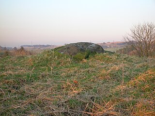
The Thurgartstone or Ogrestone is a prominent glacial erratic stone near Dunlop in East Ayrshire, Scotland. The Thurgartstone stands in a field at Brandleside Farm and is thought to have been a rocking stone at one time, but it no longer moves due to a build up of soil beneath.

<span class="mw-page-title-main">Dule tree</span> Tree used as a gallows or gibbet in Britain

Dule trees, or dool trees, in Britain were used as gallows for public hangings. They were also used as gibbets for the display of the corpse for a considerable period after such hangings. These "trees of lamentation or grief" were usually growing in prominent positions or at busy thoroughfares, particularly at crossroads, so that justice could be seen to have been done and as a salutary warning to others. Place names such as Gallows-Hill, Gallows-See, Gallows-Fey and Hill of the Gallows record the site of such places of execution.

<span class="mw-page-title-main">Cleeves Cove</span>

Cleeves Cove or Blair Cove is a solutional cave system on the Dusk Water in North Ayrshire, Scotland, close to the town of Dalry.

Old Dailly is a hamlet in South Ayrshire, Scotland. It is located west of Dailly.

<span class="mw-page-title-main">Carlin stone</span> Name of many stones in Scotland

Carlin Stone or Carline Stane is the name given to a number of prehistoric standing stones and natural stone or landscape features in Scotland. The significance of the name is unclear, other than its association with old hags, witches, and the legends of the Cailleach.

The Grannie or Granny stone is either the only surviving part of a stone circle or a simple glacial erratic. It lies in the River Irvine below the Rivergate Centre in Irvine, North Ayrshire, Scotland. The Grannie Stane is clearly visible when the water is low. The GPS co-ordinates are 55°36.768′N4°40.180′W.

<span class="mw-page-title-main">Loch Fergus</span> Freshwater loch in South Ayrshire, Scotland

Loch Fergus is a freshwater post-glacial "Kettle Hole" sometimes recorded as Fergus Loch. It is quite visible and is situated in a low-lying area close to the B742 road between the farms and dwellings of Trees, Lochfergus and Bowmanston in the Parish of Ayr, South Ayrshire, Scotland. The loch lies to the north of Martnaham Loch, four miles east-southeast of Ayr. It drains to the southwest into the Snipe Loch.

The Maak's or Monk's Well is situated beside the Carmel Water in Kilmaurs, East Ayrshire., Scotland. A possible 'Holy Well', it was once a public water supply for the villagers and residents of the old castle at Kilmaurs Place.

<span class="mw-page-title-main">Wallace's Heel Well</span> Petrosomatoglyph in South Ayrshire, Scotland, UK

Wallace's Heel Well or Wallace's Heel is located beside the River Ayr (NS35502122) near the old Holmston lime kiln, Ayr, Scotland. It is a petrosomatoglyph said to represent the imprint of a heel and is associated with the story of an escape from English soldiers made by the Scottish hero William Wallace.

<span class="mw-page-title-main">Lady's Well, Auchmannoch</span> Human settlement in Scotland

The Lady's Well is a natural spring surmounted by a large cross that stands beside the Stra Burn Ford (NS254630) near Auchmannoch House in the Parish of Sorn, East Ayrshire, Scotland. It is associated with the Virgin Mary as a curative well, a Wishing Well and also a Clootie well, additionally Mary Queen of Scots is said to have once watered her horse here. A large red sandstone cross was erected here at an unrecorded date. The well is also said to have acquired its name through "..one of the ladies of Auchmannoch family drinking water exclusively from here."

<span class="mw-page-title-main">Dunton Cove</span>

Dunton Cove or the Covenanters' Cave is an artificial cave in a craggy outcrop of rocks overlooking the Craufurdland Water just below the confluence of the Dunton Water and the Calf Fauld Water in East Ayrshire, Scotland, close to the village of Waterside. Traditionally it was used as a hiding place for Covenanters in the 17th century during the so-called 'Killing Times' of the 1680s.

<span class="mw-page-title-main">Peden's Cave (Auchinbay)</span>

Peden's Cave is at least partly artificial and is set into a craggy outcrop of red sandstone rocks overlooking the River Lugar just below the farm of Auchinbay in East Ayrshire, Scotland, close to the town of Ochiltree. Traditionally it is said that this cave was used as a hiding place for Covenanters, including the famous Covenanter minister Alexander Peden in the 17th century, mainly during the so-called 'Killing Times' of the 1680s.

<span class="mw-page-title-main">Wallace's Cave, Auchinleck</span>

Wallace's Cave in the Lugar Gorge at Auchinleck in the Parish of Auchinleck is an 18th-century grotto contemporary with Dr Johnson's Summerhouse, also located on the Auchinleck Estate. It shows superior workmanship in its construction, possibly being the enlargement of a pre-existing cave. The cave or grotto lies downstream of the confluence of the Dippol Burn with the River Lugar and is reached via a once well formed path, however access is now hazardous due to the condition of the cliff edge path and the vertical drop into the River Lugar.

<span class="mw-page-title-main">Bickering Bush</span> Scottish thorn near Caprington, linked to legend of Sir William Wallace

The Bickering bush (NS41863635) thorn grew near Caprington on the lands of Monksholm or Maxholm, Riccarton, East Ayrshire, Scotland. The old farm house at Maxholm sat in hollow on the old Caprington Castle estate and to the north and west its fields bordered the River Irvine. The thorn was located, as recorded on the OS map, near to the confluence of the Kilmarnock Water and the River Irvine, downstream of the Simon's Burn's confluence on the south bank of the river.

<span class="mw-page-title-main">Craigie, South Ayrshire</span> Human settlement in Scotland

Craigie is a small village and parish of 6,579 acres in the old district of Kyle, now South Ayrshire, four miles south of Kilmarnock, Scotland. This is mainly a farming district, lacking in woodland, with a low population density, and only one village. In the 19th century, high quality lime was quarried here with at least three sites in use in 1832.

<span class="mw-page-title-main">Murdoch's Cave</span>

Murdoch's Cave, is a relatively small artificial cave created by William Murdoch (1754-1839) and his siblings in the soft red sandstone Lugar river bank cliff just upstream of the old Bellow Mill close to the confluence of the Bellow or Bello Water and the Glenmuir Water in Lugar, East Ayrshire, Scotland. The spelling 'Bellow' is used for consistency.

<span class="mw-page-title-main">Lendalfoot</span> Human settlement in Scotland

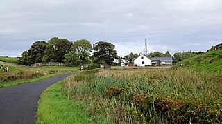
Lendalfoot is a small village located on Carleton Bay, parish of Colmonell in the old district of Carrick, now South Ayrshire, about six miles south of Girvan, Scotland. This is mainly a farming district, lacking in woodland, with a low population density. The village sits astride the A77 that runs north to Girvan and south to Cairnryan and Stranraer. Carleton Hill rises to 520 feet or 158 metres from the road and is the site near its summit of earth banks, an ancient fort.

<span class="mw-page-title-main">Carleton Castle</span> Castle in South Ayrshire, Scotland

The ruins of the five storey high 15th century Carleton Castle lie in a prominent position above the village of Lendalfoot located on Carleton Bay, parish of Colmonell in the old district of Carrick, now South Ayrshire, about 6 miles south of Girvan, Scotland.

<span class="mw-page-title-main">Minishant</span> Human settlement in Scotland

Minishant is a village bordering the A77 in the old county of Carrick, South Ayrshire, Scotland. It is located in Maybole Parish, 3+12 miles from Maybole and standing close to the River Doon. The village was originally named Culroy after the Culroy Burn that runs through it.

<span class="mw-page-title-main">Balcreuchan Port</span>

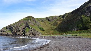
Balcreuchan Port or Balcruachan Port (NX0908878) is a bay and raised beach site in the parish of Colmonell, close to Bennane Head and Port Vad (NX091870) in South Ayrshire, Scotland. It is well known for its cave (NX099876) with its links to the legend of Sawney Bean and also for the unusual geology that is found in the bay. It was a minor fishing harbour up until the mid to late 19th century.

References

Notes
  1. Love, Dane (2013). Legendary Ayrshire. Custom : Folklore : Tradition. Carn Publishing. p. 35. ISBN   978-0-9518128-6-0.
  2. Lamb, John (1899). West Kilbride and Neighbourhood. Arthur Guthrie and Sons. p. 94.
  3. Smith, John (1895). Prehistoric Man in Ayrshire. Elliot Stock. p. 22.
  4. "Hawking Cave on Canmore" . Retrieved 16 September 2017.
  5. Smith, John (1895). Prehistoric Man in Ayrshire. Elliot Stock. p. 22.
  6. Lamb, John (1899). West Kilbride and Neighbourhood. Arthur Guthrie and Sons. p. 94.
  7. Love, Dane (2013). Legendary Ayrshire. Custom : Folklore : Tradition. Carn Publishing. p. 35. ISBN   978-0-9518128-6-0.
  8. Lamb, John (1899). West Kilbride and Neighbourhood. Arthur Guthrie and Sons. p. 94.
  9. Love, Dane (2013). Legendary Ayrshire. Custom : Folklore : Tradition. Carn Publishing. p. 35. ISBN   978-0-9518128-6-0.
  10. Love, Dane (2013). Ayrshire:Discovering a County. Fort Publishing. p. 33. ISBN   9780954446116.
  11. Lamb, John (1899). West Kilbride and Neighbourhood. Arthur Guthrie and Sons. p. 94.
  12. Love, Dane (2013). Legendary Ayrshire. Custom : Folklore : Tradition. Carn Publishing. p. 35. ISBN   978-0-9518128-6-0.
  13. Love, Dane (2013). Legendary Ayrshire. Custom : Folklore : Tradition. Carn Publishing. p. 35. ISBN   978-0-9518128-6-0.
  14. Smith, John (1895). Prehistoric Man in Ayrshire. Elliot Stock. p. 22.
  15. "Hawking Cave on Canmore" . Retrieved 16 September 2017.
  16. "Hawking Cave on Canmore" . Retrieved 16 September 2017.
  17. Clements, James (1974). Stevenston. The Kernel of Cunninghame. Burgh of Stevenston. p. 100.
  18. RCAHMS Retrieved : 2017-9-16
  19. Lamb, John (1899). West Kilbride and Neighbourhood. Arthur Guthrie and Sons. p. 94.
  20. Smith, John (1895). Prehistoric Man in Ayrshire. Elliot Stock. p. 22.
  21. Wilson, Daniel (2013). Prehistoric Annals of Scotland. Volume 2. Cambridge University Press. p. 268. ISBN   978-1-108-05480-5.
  22. Love, Dane (2013). Ayrshire: Discovering a County. Fort Publishing. p. 33. ISBN   9780954446116.