Fingal is a county in Ireland. It is in the province of Leinster and is part of the Eastern and Midland Region. It is one of three successor counties to County Dublin, which was disestablished for administrative purposes in 1994. Its name is derived from the medieval territory of Scandinavian foreigners that settled in the area. Fingal County Council is the local authority for the county. In 2016 the population of the county was 296,214, making it the second-most populous county in the state.

Blanchardstown is a large outer suburb of Dublin in the modern county of Fingal, Ireland. Located ten kilometres (6 mi) northwest of Dublin city centre, it has developed since the 1960s from a small village to a point where Greater Blanchardstown is the largest urban area in Fingal.
Castleknock is an affluent suburb located 8 km (5 mi) west of the centre of Dublin city, Ireland. It is centered on the village of the same name in Fingal.

Mulhuddart is an outer suburb situated 12 km north-west of Dublin, Ireland. The River Tolka passes near the village.

Clonsilla is an outer suburb of Dublin in Fingal, Ireland.

Dublin 15, also rendered as D15, is a postal district in the suburbs of Dublin in Fingal, Ireland. It is 11 km (6.8 mi) west of the GPO in Dublin city.
Coolmine is a primarily residential suburb of Dublin, Ireland, in the jurisdiction of Fingal. It is also a townland in the civil parish of Clonsilla.

Tyrrelstown is a townland in the civil parish of Mulhuddart, located 13 km northwest of the city of Dublin in Ireland and often considered as part of the greater Blanchardstown area. It is the site of a planned suburban development from the early 2000s. The local authority for the area, which forms part of the Dublin 15 postal district, is Fingal County Council.

Chapelizod is a village preserved within the city of Dublin, Ireland. It lies in the wooded valley of the River Liffey, near the Strawberry Beds and the Phoenix Park. The village is associated with Iseult of Ireland and the location of Iseult's chapel. Chapelizod is under the administration of Dublin City Council.

Ongar is an outer western suburb of Dublin, Ireland. Developed on a greenfield basis since 2001, it comprises the townlands of Castaheany (northerly) and "Hansfield or Phibblestown" (southerly), within the ancient Barony of Castleknock, County Dublin. It is close to Castleknock, Blanchardstown and Clonsilla. The development has a number of amenities on the main street, there are several schools in the area, and the nearby railway line at Hansfield railway station connects to the Luas Green Line and ultimately the N3 national route / M3 motorway. Employers in the nearby business parks and "Greater Blanchardstown" include Intel, Hewlett Packard, IBM, Kepak and eBay.

Castleknock Hurling and Football Club is a Dublin GAA club centered on the townlands of Carpenterstown and Diswellstown in the civil parish of Castleknock in Fingal, Ireland. It serves large parts of the suburban areas of Castleknock, Hartstown, Coolmine, Blanchardstown, Laurel Lodge and Clonsilla. The club plays the following Gaelic games at all age levels from nursery to adult: Hurling, Gaelic football, Camogie and Ladies' Gaelic football.

Hansfield railway station is a railway station in Fingal, Ireland. It lies on the Docklands to M3 Parkway Commuter service and serves the housing estates of Ongar and Barnwell in the townland of Hansfield.

Cumann Naomh Peregrine is a Gaelic Athletic Association club in Clonsilla, Fingal, Ireland. It was founded in 1978 when a group of local people got together with Fr. Joe Madden of the Servite Order and decided to form a GAA club of their own.
The barony of Castleknock is one of the baronies of Ireland. Originally part of the Lordship of Meath, it was then constituted as part of the historic County Dublin. Today, it lies in the modern county of Fingal, Ireland. The barony was originally also a feudal title, which became one of the subsidiary titles of the Viscounts Gormanston.
Huntstown and Littlepace is a set of modern housing developments that forms a remote suburb of Dublin city in the county of Fingal in Ireland. It was built in the townlands of Littlepace (westerly) and Huntstown (easterly) which are the southernmost townlands of the civil parish of Mulhuddart. The district is also a parish in the Blanchardstown deanery of the Roman Catholic Archdiocese of Dublin. The nearest villages in the county are Ongar, Mulhuddart and Clonsilla along with Clonee in County Meath.
Castleknock is a civil parish and a townland located in the south-western corner of the modern county of Fingal, Ireland. The civil parish is part of the ancient barony of Castleknock. It is centred on the suburban village of Castleknock. The townland of Castleknock itself is the location of the eponymous "Cnucha's Castle" – Castleknock Castle. The town with the biggest population in the parish is Blanchardstown. In geology, the parish rests on a substratum of limestone and comprises 2943 statute acres, the whole of which is arable land.
Lexilip is a civil parish and a townland located in the north-eastern corner of County Kildare, Ireland. The civil parish is mainly in the ancient barony of Salt North with a small part in the neighbouring barony of Newcastle. It is centred on the town of Leixlip. In geology, the parish rests on a substratum of limestone, and contains chalybeate springs. It lies at the confluence of the River Liffey and the Rye Water.
Carpenterstown is a townland in the civil parish of Castleknock. The civil parish is part in the ancient barony of Castleknock. In geology, the townland rests on a substratum of limestone and comprises 166 statute acres, the whole of which is arable land.

Saint Margaret's is a civil parish and townland in the historical barony of Coolock in Dublin, Ireland. Rivermeade, a housing estate of 175 homes which is treated as a separate census town, is located between Saint Margaret's and the Ward River. Dublin Airport is also nearby.

Strawberry Beds or The Strawberry Beds is a locality and small settlement 7 km to the west of Dublin City, Ireland, located on the northern banks of the River Liffey between Chapelizod and Lucan where the closest bridges span the river. The populated suburb of Palmerstown lies just south of the Strawberry Beds, but is inaccessible due to the Liffey which separates them. The R109 road, also known as the 'Lower Road' for the section between Chapelizod and Lucan, is the only road that passes through the Strawberry Beds. The area is protected by a Special Amenity Area Order (SAAO).
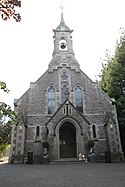
 St. Bridget's church, Castleknock
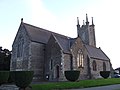
 St. Mary's church, Clonsilla
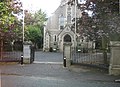 St. Mochta's parish church
 St. Ciaran's parish church at Hartstown