The Nation is a municipality in Eastern Ontario, located within Canada's National Capital Region, in the United Counties of Prescott and Russell. The municipality consists of the former geographic townships of Caledonia, Cambridge and South Plantagenet.

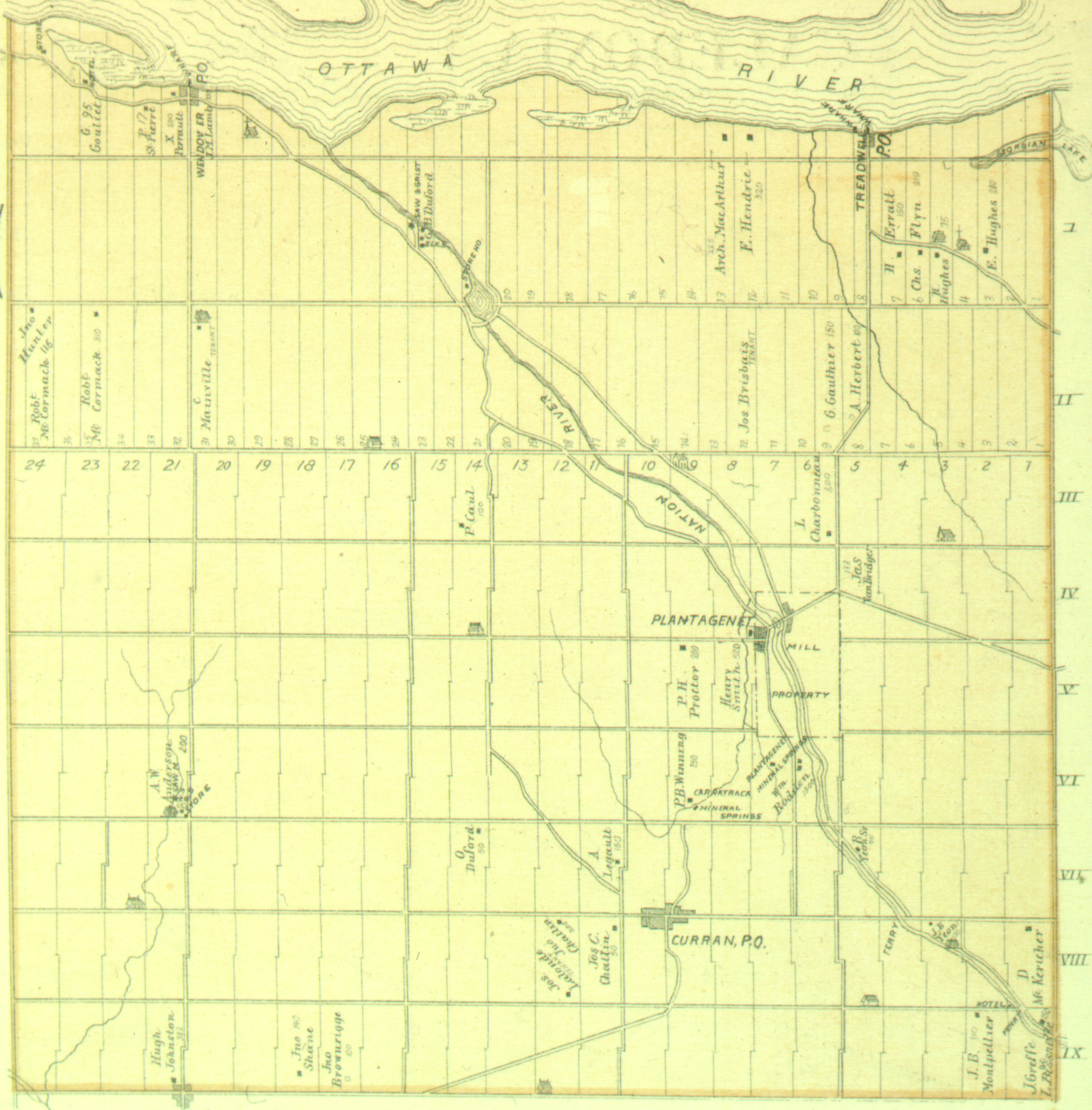
Alfred and Plantagenet is a township in eastern Ontario, Canada, in the United Counties of Prescott and Russell. Located approximately 70 km (43 mi) from downtown Ottawa at the confluence of the Ottawa River and the South Nation River.
The Indian River is a river in Lanark County in Eastern Ontario, Canada. It is in the Saint Lawrence River drainage basin and is a left tributary of the Mississippi River.

The United Counties of Prescott and Russell are consolidated counties located in the Canadian province of Ontario. Its county seat is L'Orignal. It was created as a result of a merger between Russell County and Prescott County in 1820. It is located in Eastern Ontario, in the wedge-shaped area between the Ottawa River and St. Lawrence River, approximately 55 km east of the City of Ottawa.
Prescott County is a historic county in the Canadian province of Ontario.

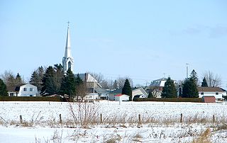
Bourget is a village in Eastern Ontario, Canada, near the Cobbs Lake Creek, in the city of Clarence-Rockland in the United Counties of Prescott and Russell.

Glengarry—Prescott—Russell is a federal electoral district in Ontario, Canada, that has been represented in the House of Commons of Canada since 1953.

The Clyde River is a river in Lanark County in Eastern Ontario, Canada. It is in the Saint Lawrence River drainage basin, is a left tributary of the Mississippi River, and was named after the River Clyde in Scotland.
Colchester South Township was a former incorporated township and is now a geographic township located in Essex County in Southwestern Ontario, Canada. Located on Lake Erie, the incorporated township comprised the towns of Colchester and Harrow. It was amalgamated into the Town of Essex in 1999.
Glengarry—Prescott—Russell is a provincial electoral district in eastern Ontario, Canada. It elects one member to the Legislative Assembly of Ontario.

Caledonia Springs is now an unincorporated community in the northwest of the municipality of The Nation, Prescott and Russell United Counties in eastern Ontario, Canada. It is part of the National Capital Region and is in the geographic county of Caledonia.
Mitchell Lake is a small, man-made lake in the Great Lakes Basin and located in the city of Kawartha Lakes in Central Ontario, Canada. The lake was formed sometime in the first decade of the twentieth century alongside the construction of the Kirkfield Lift Lock, which was completed and operational by the end of 1907. It is part of the summit of the Trent–Severn Waterway, the middle of a connection via canals of Balsam Lake on the Gull River system, which flows eventually to Lake Ontario, and the Kirkfield Lift Lock and Canal Lake on the Talbot River system, which flows to Lake Simcoe and eventually to Lake Huron.

Norcan Lake is a reservoir lake in the municipality of North Frontenac, Frontenac County in Eastern Ontario, Canada. It is on the Madawaska River system, is part of the Saint Lawrence River drainage basin, and is located in geographic townships of North Canonto Township and South Canonto Township.
Calabogie Lake is a reservoir lake in the municipality of Greater Madawaska, Renfrew County in Eastern Ontario, Canada. It is on the Madawaska River system, is part of the Saint Lawrence River drainage basin, and is located in the geographic townships of Bagot Township and Blythfield Township.
The Little Clyde River is a river in the municipality of Lanark Highlands, Lanark County in Eastern Ontario, Canada. It is in the Saint Lawrence River drainage basin, is a right tributary of the Clyde River, and was named after the River Clyde in Scotland.

The Boyne River is a river in the municipality of Grey Highlands, Grey County in Southwestern Ontario, Canada. It is part of the Great Lakes Basin, and lies entirely within geographic Artemesia Township.
Black Creek is a stream in the municipalities of Tay Valley, Lanark County and Rideau Lakes, United Counties of Leeds and Grenville in Eastern Ontario, Canada. It flows from an unnamed lake in Rideau Lakes to the west shore of Big Rideau Lake in Tay Valley. Big Rideau Lake, on the Rideau Canal, flows via the Rideau River and Ottawa River to the Saint Lawrence River. The stream has a drainage basin of 94 square kilometres (36 sq mi).
Lynde Creek is a stream in the municipalities of Whitby and Scugog, Regional Municipality of Durham, in the Greater Toronto Area of Ontario, Canada. It is in the Great Lakes Basin, is a tributary of Lake Ontario, and is under the auspices of the Central Lake Ontario Conservation Authority. The creek begins on the Oak Ridges Moraine in geographic Reach Township in the municipality of Scugog, and flows south to its mouth in the southwest of the town of Whitby. Portions of the 132.19-square-kilometre (51.04 sq mi) watershed also extend into the town of Ajax, the city of Pickering and the municipality of Uxbridge.

Salem is a dispersed rural community and unincorporated place in the municipality of Arran–Elderslie, Bruce County in southwestern Ontario, Canada. The community is in geographic Elderslie Township at the intersection of Concession 10 Elderslie and Sideroad 15 South Elderslie, 10 kilometres (6.2 mi) northwest of the community of Chesley and 9 kilometres (5.6 mi) northeast of the community of Paisley. The community is on Snake Creek, a tributary of the Saugeen River.
The Prescott-Russell Recreational Trail is a 72-km long rail trail in Prescott-Russell, Ontario, Canada, maintained by the county of Prescott-Russell. The trail begins in the village of Saint-Eugène and goes to the eastern boundary of the City of Ottawa, passing through the townships of East Hawkesbury, Champlain, The Nation, Alfred and Plantagenet, and Clarence-Rockland. The trail primarily passes through farmland, with some forested sections. Because it runs along a railway right-of-way, it is extremely flat. The trail surface is mainly stone dust, although it is paved near population centres. Notable sights along the trail include the former railway station in Bourget and the bridge over the South Nation River near Plantagenet. Pavilions are located along the trail in Saint-Eugène, Vankleek Hill, Plantagenet, Bourget, and Hammond.
