Cobscook Bay

Last updated
Looking west into Cobscook Bay from Shackford Head State Park in Eastport CobscookBay.jpg
Looking west into Cobscook Bay from Shackford Head State Park in Eastport

Cobscook Bay is located in Washington County in the state of Maine. It opens into Passamaquoddy Bay, within the Bay of Fundy. Cobscook Bay is immediately south of the island city of Eastport, the main island of which (Moose Island) straddles the two bays. In the 1930s, Cobscook Bay was part of the aborted Passamaquoddy Bay Tidal Power Project (a.k.a., Quoddy Dam Project) to generate electricity from its large tidal range.

Contents

Geography

Cobscook Bay is a large bay in Washington County, Maine that opens into Passamaquoddy Bay within the Bay of Fundy through a relatively narrow opening. It is about 10 miles (16 km) long and 10 wide and has a long, convoluted coastline with many islands. The mouth of the bay is bracketed by the island city of Eastport, which is principally on Moose Island, and by the town of Lubec. Other townships around the bay are Perry, Pembroke, Dennysville, Edmunds, and Tresscott. [1] There are about 7,000 people living in the nine communities in the area, many of whom are fishermen or work in fish farming, shipping or tourism. There is a scallop fishery here. [2]

The bay is both geologically and hydrologically complex. The tide has an average range of 18.4 feet (5.6 m) (and range that can exceed 26 feet) and there are strong currents as large volumes of sea water flow into and out of the bay twice a day. [1] The bay is very shallow with the average depth being about 10 metres (33 ft) and about one third of its area is exposed at low water. [2] The volume of freshwater entering from streams is relatively small and the nutrient rich waters support a great diversity of phytoplankton and algae. These support a biodiverse community of fish, shellfish, marine worms and other invertebrates. Many birds feed on these and the bay is an important visiting place for migrating birds and waterfowl. [1]

The area surrounding the bay is well-timbered, but as well as forests there are streams, lakes, bogs, marshes and mudflats interspersed by a network of trails. [3] Cobscook Bay State Park takes up part of the shore of the bay.

History

Eastport Museum Quoddy Dam Project Exhibit Eastport Museum Quoddy Dam Project Exhibit 16 31 46 151000.jpeg
Eastport Museum Quoddy Dam Project Exhibit

Communities around the bay were traditionally involved in shipbuilding, logging, farming, fishing and trading. [3]

In 1935, a proposal by FDR friend and engineer Dexter Cooper [4] [5] to build a barrage to harness the power of the tides in the area was inititiated. The Quoddy Dam Project was envisaged to impound the waters of Cobscook Bay and the adjoining Passamaquoddy Bay. Construction was started and some dikes were built, but a year later, the United States Congress withdrew its support and funding and the scheme was abandoned. The Quoddy Dam Model Museum at Eastport preserves a large model of the project. [4] [6] [7] [8] [9]

The generation of electricity from the bay's tidal currents was ultimately accomplished in September 2012 by Ocean Renewable Power Company. [10] A turbine was installed in Cobscook Bay at the boundary of Eastport and Lubec capable of generating 180 kW of electricity, and was the first North American commercial tidal energy project to supply power to the electrical grid. [10] The turbines did not need dams to function and were mounted on the sea bed. The turbine blades spin slowly in the current and testing seems to indicate they are harmless to marine life. Two more turbines were planned for installation in the bay within a year's time. [11]

Ecology

This coastal area is home to many resident birds. One of these is the bald eagle (Haliaeetus leucocephalus) and Cobscook Bay has more pairs of these rare birds per square mile than the rest of Maine. It also houses 25% of the state's black duck (Anas rubripes) population. In the fall, the bay is used by large numbers of birds migrating southwards from their summer breeding grounds. Rare species of bird to be seen here include the harlequin duck (Histrionicus histrionicus). An invertebrate of special concern is the mystery snail ( Vertigo paradoxa ), an air-breathing land snail. [1] In the summer several species of whale enter the bay, including the minke, fin whale and right whale. [2]

Conservation

Efforts are being made to preserve the biodiversity of the bay. A 250-foot (76 m) buffer zone has been created adjacent to the foreshore where no development is allowed. The alewife (Alosa pseudoharengus) is a species of anadromous fish which goes upstream to spawn. Efforts are being made to enable these fish to reach their traditional spawning grounds in the upper waters of the Pennamaquan River, Little River and Boyden Stream. These fish are thought to be important in the bay's ecosystem by providing food for the eagles. [1]

Other uses of the name

"Cobscook Bay" is also the title of a song by The Mountain Goats from their EP Isopanisad Radio Hour.

Related Research Articles

Bay of Fundy Bay on the east coast of North America

The Bay of Fundy is a bay between the Canadian provinces of New Brunswick and Nova Scotia, with a small portion touching the U.S. state of Maine. Its extremely high tidal range is the highest in the world. The name is likely a corruption of the French word fendu, meaning 'split'.

Eastport, Maine City in Maine, United States

Eastport is a city and archipelago in Washington County, Maine, United States. The population was 1,288 at the 2020 census, making Eastport the least-populous city in Maine. The principal island is Moose Island, which is connected to the mainland by a causeway. Eastport is the easternmost city in the United States.

Lubec, Maine Town in Maine, United States

Lubec is a town in Washington County, Maine, United States. It is the easternmost municipality in the contiguous U.S. and is the country's closest continental location to Africa.

Tidal power Technology to convert the energy from tides into useful forms of power

Tidal power or tidal energy is harnessed by converting energy from tides into useful forms of power, mainly electricity using various methods.

Campobello Island Island in Campobello, New Brunswick, Canada

Campobello Island is the largest and only inhabited island in Campobello, a civil parish in southwestern New Brunswick, near the border with Maine. The island's permanent population in 2016 was 872. It is the site of the Roosevelt Campobello International Park and of Herring Cove Provincial Park.

Deer Island is one of the Fundy Islands in the Bay of Fundy, Canada. It is at the entrance to Passamaquoddy Bay. The island was first settled by colonists around 1770.

Passamaquoddy Bay International inlet of the Bay of Fundy

Passamaquoddy Bay is an inlet of the Bay of Fundy, between the U.S. state of Maine and the Canadian province of New Brunswick, at the mouth of the St. Croix River. Most of the bay lies within Canada, with its western shore bounded by Washington County, Maine. The southernmost point is formed by West Quoddy Head on the U.S. mainland in Lubec, Maine; and runs northeasterly through Campobello Island, New Brunswick, engulfing Deer Island, New Brunswick, to the New Brunswick mainland head at L'Etete, New Brunswick in Charlotte County, New Brunswick.

Old Sow is the largest tidal whirlpool in the Western Hemisphere, located off the southwestern shore of Deer Island, New Brunswick, Canada, and off the northeast shore of Moose Island, the principal island of Eastport, Maine.

Annapolis Royal Generating Station Canadian tidal power generating station

The Annapolis Royal Generating Station was a tidal power generating station in the Bay of Fundy in Nova Scotia, Canada. When operational, it was the only tidal generating station in North America and was one of the few in the world. Located upstream of Annapolis Royal, Nova Scotia, it generated about 30 million kilowatt hours per year, enough for 4500 houses. Peak output was 20 megawatts.

Moose Island is an island in Eastport, Maine located at the entrance to Cobscook Bay from Passamaquoddy Bay in the Bay of Fundy. It is part of Shackford Head State Park.

Marine Current Turbines Ltd (MCT), is a United Kingdom-based company which is developing tidal stream generators. It is owned by the German automation company, Siemens.

Low-head hydropower refers to the development of hydroelectric power where the head is typically less than 20 metres, although precise definitions vary. Head is the vertical height measured between the hydro intake water level and the water level at the point of discharge. Using only a low head drop in a river or tidal flows to create electricity may provide a renewable energy source that will have a minimal impact on the environment. Since the generated power is a function of the head these systems are typically classed as small-scale hydropower, which have an installed capacity of less than 5MW.

Lubec Channel Light Lighthouse in Maine, US

Lubec Channel Light is a sparkplug lighthouse in Lubec, Maine. Established in 1890, it is one of three surviving sparkplug lights in the state, and served as an important aid to navigation on the route from the Bay of Fundy to Eastport, Maine and the St. Croix River It is set in shallow waters in the Lubec Channel, about 500 feet (150 m) from the Canada–United States border. The lighthouse was listed on the National Register of Historic Places as Lubec Channel Light Station on March 14, 1988. The lighthouse was sold by auction into private hands on 2007.

Tidal farm

A tidal farm is a group of multiple tidal stream generators assembled in the same location used for production of electric power, similar to that of a wind farm. The low-voltage powerlines from the individual units are then connected to a substation, where the voltage is stepped up with the use of a transformer for distribution through a high voltage transmission system.

West Quoddy Lifesaving Station United States historic place

West Quoddy Lifesaving Station is a historic coastal rescue station on West Quoddy Head in Lubec, Maine. The lifesaving station was built in 1919, and was operated by the United States Coast Guard until 1972. It was listed on the National Register of Historic Places on April 20, 1990. It now houses a bed and breakfast inn.

Tidal stream generator Type of tidal power generation technology

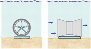
A tidal stream generator, often referred to as a tidal energy converter (TEC), is a machine that extracts energy from moving masses of water, in particular tides, although the term is often used in reference to machines designed to extract energy from run of river or tidal estuarine sites. Certain types of these machines function very much like underwater wind turbines, and are thus often referred to as tidal turbines. They were first conceived in the 1970s during the oil crisis.

Tidal barrage Dam-like structure

A tidal barrage is a dam-like structure used to capture the energy from masses of water moving in and out of a bay or river due to tidal forces.

The Quoddy Tides is a community newspaper published in Eastport, Maine covering several communities in Washington County, Maine and Charlotte County, New Brunswick. It styles itself the "most easterly published newspaper in the United States". It is published on the second and fourth Friday of each month. The first issue was published on November 29, 1968.

Grand Harbour Lighthouse Lighthouse

The Grand Harbour Lighthouse was a Canadian lighthouse marking the entrance to Grand Harbour, Grand Manan, New Brunswick. It was built and first lit in 1879 and was decommissioned in 1963. It was severely damaged in the Groundhog Day gale of 1976 and destroyed by a gale in November 2013.

References

  1. 1 2 3 4 5 "Cobscook Bay" (PDF). Maine Government. Retrieved 2012-12-25.
  2. 1 2 3 "Cobscook Bay Resource Center" . Retrieved 2012-12-27.
  3. 1 2 "Down East: The nature of Maine" (PDF). Cobscock Bay Area Chamber of Commerce. Archived from the original (PDF) on 2013-09-01. Retrieved 2012-12-27.
  4. 1 2 "D. P. COOPER DEAD; 'QUODDY'S' FATHER; Engineer Who Sponsored Vast Power Project a Leading Hydraulic Expert" (PDF). Retrieved 2018-08-07.
  5. "Surging ahead | Wind power's not the only game in town. Portland's ORPC is making waves with its tidal energy technology". Mainebiz. Retrieved 2018-08-07.
  6. "Quoddy Dam Model Museum". Border Historical Society. Retrieved December 27, 2012.
  7. Bidgood, Jess. "Turbine to Harness the Tides to Generate Power" . Retrieved 2018-08-07.
  8. "Eastport, Maine Tidal Project". newengland.com. Retrieved 2018-08-07.
  9. Fountain, Henry. "F.D.R.'s Brief Dip Into Tidal Energy". Green Blog. Retrieved 2018-08-07.
  10. 1 2 Woodard, Colin (September 13, 2012). "Maine tidal turbine goes online, first in North America". Portland Press Herald. Retrieved January 1, 2013.
  11. Woodard, Colin (July 22, 2012). "Maine company leading way as tidal energy comes of age". Portland Press Herald. Retrieved December 27, 2012.

Coordinates: 44°54′52″N67°03′05″W / 44.91444°N 67.05139°W / 44.91444; -67.05139