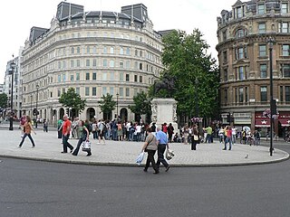
Charing Cross is a junction in London, England, where six routes meet. Clockwise from north these are: the east side of Trafalgar Square leading to St Martin's Place and then Charing Cross Road; the Strand leading to the City; Northumberland Avenue leading to the Thames Embankment; Whitehall leading to Parliament Square; The Mall leading to Admiralty Arch and Buckingham Palace; and two short roads leading to Pall Mall. The name also commonly refers to the Queen Eleanor Memorial Cross at Charing Cross station.

Trafalgar Square is a public square in the City of Westminster, Central London, established in the early 19th century around the area formerly known as Charing Cross. At its centre a high column bearing a statue of Admiral Nelson commemorates his victory at Battle of Trafalgar, the British naval victory in the Napoleonic Wars over France and Spain that took place on 21 October 1805 off the coast of Cape Trafalgar.
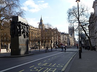
Whitehall is a road and area in the City of Westminster, Central London. The road forms the first part of the A3212 road from Trafalgar Square to Chelsea. It is the main thoroughfare running south from Trafalgar Square towards Parliament Square. The street is recognised as the centre of the Government of the United Kingdom and is lined with numerous departments and ministries, including the Ministry of Defence, Horse Guards and the Cabinet Office. Consequently, the name "Whitehall" is used as a metonym for the British civil service and government, and as the geographic name for the surrounding area.

Wardour Street is a street in Soho, City of Westminster, London. It is a one-way street that runs north from Leicester Square, through Chinatown, across Shaftesbury Avenue to Oxford Street. Throughout the 20th century the street became a centre for the British film industry and the popular music scene.

Pall Mall is a street in the St James's area of the City of Westminster, Central London. It connects St James's Street to Trafalgar Square and is a section of the regional A4 road. The street's name is derived from pall-mall, a ball game played there during the 17th century, which in turn is derived from the Italian pallamaglio, literally ball-mallet.

St James's is a central district in the City of Westminster, London, forming part of the West End. In the 17th century the area developed as a residential location for the British aristocracy, and around the 19th century was the focus of the development of gentlemen's clubs. Once part of the parish of St Martin in the Fields, much of it formed the parish of St James from 1685 to 1922. Since the Second World War the area has transitioned from residential to commercial use.

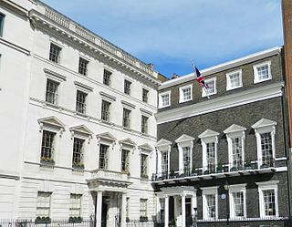
St James's Square is the only square in the St James's district of the City of Westminster and is a garden square. It has predominantly Georgian and Neo-Georgian architecture. For its first two hundred or so years it was one of the three or four most fashionable residential streets in London. It now has headquarters of a number of well-known businesses, including BP and Rio Tinto Group; four private members' clubs, the East India Club, the Naval and Military Club, the Canning Club, and the Army and Navy Club; the High Commission of Cyprus; the London Library; and global think tank and peace-promoter Chatham House.

Bedford Square is a garden square in the Bloomsbury district of the Borough of Camden in London, England.
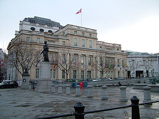
The High Commission of Canada in the United Kingdom is the diplomatic mission of Canada to the United Kingdom. It is housed at Canada House on Trafalgar Square in central London, with an additional Regional Service Centre at 3 Furzeground Way in Stockley Park, Uxbridge.
Carlton House Terrace is a street in the St James's district of the City of Westminster in London. Its principal architectural feature is a pair of terraces of white stucco-faced houses on the south side of the street overlooking St. James's Park. These terraces were built on Crown land between 1827 and 1832 to overall designs by John Nash, but with detailed input by other architects including Decimus Burton, who exclusively designed numbers 3 and 4.

Coventry Street is a short street in the West End of London, connecting Piccadilly Circus to Leicester Square. Part of the street is a section of the A4, a major road through London. It is named after the politician Henry Coventry, secretary of state to Charles II.

The Survey of London is a research project to produce a comprehensive architectural survey of central London and its suburbs, or the area formerly administered by the London County Council. It was founded in 1894 by Charles Robert Ashbee, an Arts-and-Crafts designer, architect and social reformer and was motivated by a desire to record and preserve London's ancient monuments. The first volume was published in 1900, but the completion of the series remains far in the future.
Den Norske Klub is a social club based in London. It was founded on 17 May 1887. Its members are Norwegians living in London or Britons with a connection to or interest in Norway. It is the oldest club of its kind in the UK and is still an important meeting place for the Norwegian community in London.

The Pall Mall Restaurant was a hostelry situated at Number 1 Cockspur Street, Westminster, London, just off Pall Mall and near Trafalgar Square. The site was subsequently the offices of the White Star Line, and was then occupied by a Tex Mex restaurant, the Texas Embassy Cantina. Currently the site is unused.
Canada House is a Greek Revival building on Trafalgar Square in London. It has been a Grade II* Listed Building since 1970. It has served as the offices of the High Commission of Canada in the United Kingdom since 1925.

Matthew Cotes Wyatt was a painter and sculptor and a member of the Wyatt family, who were well known in the Victorian era as architects and sculptors.

Spring Gardens is a dead-end street at the south east extreme of St. James's, London, England, that crosses the east end of The Mall between Admiralty Arch and Trafalgar Square. Part of the old liberty of Westminster and the current City of Westminster, it abuts Whitehall, Horse Guards Parade, Green Park, and the Charing Cross/Strand/Trafalgar Square locality.
The A400 road is an A road in London that runs from Charing Cross to Archway in North London. It passes some of London's most famous landmarks.

Morley's Hotel was a building which occupied the entire eastern side of London's Trafalgar Square, until it was demolished in 1936 and replaced with South Africa House. It was next to St Martin-in-the-Fields Church.
Josiah Emery was a watch and clock maker who improved Thomas Mudge's lever escapement in 1785. One of his watches was presented to Lord Nelson who was wearing it when he was killed by a sniper at the Battle of Trafalgar in 1805. Others were made for George III.


