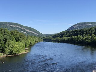
The Delaware River is a major river in the Mid-Atlantic region of the United States and is the longest free-flowing (undammed) river in the Eastern United States. From the meeting of its branches in Hancock, New York, the river flows for 282 miles (454 km) along the borders of New York, Pennsylvania, New Jersey, and Delaware, before emptying into Delaware Bay.

Route 49 is a state highway in the southern part of the U.S. state of New Jersey. It runs 53.80 mi (86.58 km) from an interchange with the New Jersey Turnpike, Interstate 295 (I-295), and U.S. Route 40 (US 40) in Deepwater, Salem County, southeast to Route 50/County Route 557 in Tuckahoe, Cape May County. The route serves Salem, Cumberland, Atlantic, and Cape May counties, passing through rural areas and the communities of Salem, Bridgeton, and Millville along the way. It is a two-lane, undivided road for most of its length.

The Delaware and Raritan Canal is a canal in central New Jersey, built in the 1830s, that connects the Delaware River to the Raritan River. It was an efficient and reliable means of transportation of freight between Philadelphia and New York City, transporting anthracite coal from eastern Pennsylvania during much of the 19th and early 20th centuries. The canal allowed shippers to cut many miles off the existing route from the Pennsylvania Coal Region down the Delaware, around Cape May, and up the occasionally treacherous Atlantic Ocean coast to New York City.

Delaware Bay is the estuary outlet of the Delaware River on the northeast seaboard of the United States, lying between the states of Delaware and New Jersey. It is approximately 782 square miles (2,030 km2) in area, the bay's freshwater mixes for many miles with the saltwater of the Atlantic Ocean.

The Maurice River is a tributary of Delaware Bay in Salem County and Cumberland County, New Jersey in the United States. The river was named for Maurice, Prince of Orange.

The Salem River is a 34.7-mile-long (55.8 km) tributary of the Delaware River in southwestern New Jersey in the United States.
The Indian River is a river and estuary, approximately 15 mi (24 km) long, in Sussex County in southern Delaware in the United States. The river is named after a Native American reservation that was located on its upper reaches.

The Caloosahatchee River is a river on the southwest Gulf Coast of Florida in the United States, approximately 67 miles (108 km) long. It drains rural areas on the northern edge of the Everglades, east of Fort Myers. An important link in the Okeechobee Waterway, a manmade inland waterway system of southern Florida, the river forms a tidal estuary along most of its course and has become the subject of efforts to restore and preserve the Everglades.

Alloway Creek is a 23.2-mile-long (37.3 km) tributary of the Delaware River in Salem County, New Jersey in the United States. The name is a derivative of Allowas, an Indian chief. It has also been known by other names: Aloes River, Aloes Creek, Cotton River, Korten River, Short River, Monmouth River, Munmouth River, and Roiter's River.

The Elk River is a tidal tributary of the Chesapeake Bay on the Eastern Shore of Maryland and on the northern edge of the Delmarva Peninsula. It is about 15 miles (24 km) long. As the most northeastern extension of the Chesapeake Bay estuary, it has served as one entrance to the Chesapeake & Delaware Canal since the 19th century. The canal and river now serve as one boundary of the Elk Neck Peninsula. The river flows through Cecil County, Maryland, with its watershed extending into New Castle County, Delaware and Chester County, Pennsylvania. Elkton, the county seat of Cecil County, is located at its head. Its total watershed area is 143 square miles (370 km2), with 21 square miles (54 km2) of open water, so its watershed is 15% open water. It is south and east of the North East River, and north of the Sassafras River.

The Port of New York and New Jersey is the port district of the New York-Newark metropolitan area, encompassing the region within approximately a 25-mile (40 km) radius of the Statue of Liberty National Monument.

New Jersey is a state within the United States of America that lies on the north eastern edge of the North American continent. It shares a land border with the state of New York along the north, ratified by both states after the New York – New Jersey Line War, which is its only straight line border.
Cohansey Township was a township that existed in Cumberland County, New Jersey, United States, during two separate periods, from 1697 to 1748 and from 1848 to 1865. The name was derived from the Cohansey River, which flows through the area.
Norwalk Harbor is a recreational and commercial harbor and seaport at the estuary of the Norwalk River where it flows into Long Island Sound in Norwalk, Connecticut, United States.
Mary Elmer Lake is a reservoir on the Cohansey River in Cumberland County, New Jersey, used for water-supply and recreation purposes.
The Flood of 1934 was a natural disaster that hit the town of Bridgeton, New Jersey on August 2 and 3, 1934. Over the course of three days, storms brought 7 inches (180 mm) of rain to the region, swelling Sunset Lake and other local interconnected waterways. At the time, there were two earthen dams holding the water back at Sunset Lake and Mary Elmer Lake. Eventually the pressure was too much and the dams gave way sending a torrent of water down the Cohansey River as well as tributaries connected to the Lakes. The wall of water surged down through the banks of the Cohansey, emptying the lakes and the Raceway and flowing into and through downtown Bridgeton, which straddles the river. All the bridges that connected the east and west sides of the town were destroyed. Also damaged was Tumbling Dam Park, where the dam that held the water of Sunset Lake was located. An estimated $1 million in damage was caused by the flooding.
The Port of Paulsboro is located on the Delaware River and Mantua Creek in and around Paulsboro, in Gloucester County, New Jersey, approximately 78 miles (126 km) from the Atlantic Ocean. Traditionally one of the nation's busiest for marine transfer operations, notably for crude oil and petroleum products, such as jet fuel and asphalt, it is a port of entry with several facilities within a foreign trade zone.

The Port of Salem is a shallow-draft port in the vicinity of the Salem River Cut-Off on the Salem River in Salem, New Jersey in the United States about 2 miles (3.2 km) east of the Delaware River and about 54 miles (87 km) from the Atlantic Ocean. It was re-designated a port of entry in 1984 and became a foreign trade zone (FTZ) in 1987. Transloading operations include the handling of a variety of bulk cargo, notably of construction aggregate, break bulk cargo, and containers for clothing, fishing apparel, agricultural produce, and other consumer goods, and has at times involved lighterage. It is operated under the auspices of the South Jersey Port Corporation. The port is envisioned as being a component of the supply chain for the development of windpower in the Atlantic Ocean off the coast of New Jersey.

Greenwich is an unincorporated community and census-designated place (CDP) in Cumberland County, in the U.S. state of New Jersey. It is in the western part of the county, in the southeast part of Greenwich Township, on the northwest side of the tidal Cohansey River, 4 miles (6 km) northeast of its mouth at Delaware Bay. The community is 7 miles (11 km) southwest of Bridgeton, the county seat.
Sheppards Mill is an unincorporated community and census-designated place (CDP) in Cumberland County, in the U.S. state of New Jersey. It is located in the western part of the county in northeastern Greenwich Township and southwestern Hopewell Township. The community is centered on Mill Creek, which is dammed to form Sheppards Millpond in the northwestern part of the CDP. Mill Creek is a southwest-flowing tributary of Wheaton Run, part of the Cohansey River watershed leading to Delaware Bay.
