
Mount Adams, known by some Native American tribes as Pahto or Klickitat, is an active stratovolcano in the Cascade Range. Although Adams has not erupted in more than 1,000 years, it is not considered extinct. It is the second-highest mountain in Washington, after Mount Rainier.

Gifford Pinchot National Forest is a National Forest located in southern Washington, managed by the United States Forest Service. With an area of 1.32 million acres (5,300 km2), it extends 116 km (72 mi) along the western slopes of Cascade Range from Mount Rainier National Park to the Columbia River. The forest straddles the crest of the South Cascades of Washington State, spread out over broad old-growth forests, high mountain meadows, several glaciers, and numerous volcanic peaks. The forest's highest point is at 12,276 ft (3,742 m) at the top of Mount Adams, the second-tallest volcano in the state after Rainier. Often found abbreviated GPNF on maps and in texts, it includes the 110,000-acre (450 km2) Mount St. Helens National Volcanic Monument, established by Congress in 1982.

Indian Heaven is a volcanic field in Skamania County in the state of Washington, in the United States. Midway between Mount St. Helens and Mount Adams, the field dates from the Pleistocene to the early Holocene epoch. It trends north to south and is dominated by six small shield volcanoes; these shields are topped by small spatter and cinder cones, and the field includes a number of subglacial volcanoes and tuyas. The northernmost peak in the field is Sawtooth Mountain and the southernmost is Red Mountain; its highest point is Lemei Rock at an elevation of 5,925 feet (1,806 m).

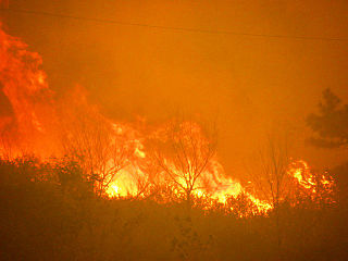
The B&B Complex fires were a linked pair of wildfires that together burned 90,769 acres (367.33 km2) of Oregon forest during the summer of 2003. The fire complex began as two separate fires, the Bear Butte Fire and the Booth Fire. The two fires were reported on the same day and eventually burned together, forming a single fire area that stretched along the crest of the Cascade Mountains between Mount Jefferson and Mount Washington. On the western side of the Cascades, the fire consumed mostly Douglas-fir and western hemlock. On the eastern side of the mountains, the fire burned mostly Ponderosa pine, lodgepole pine, and jack pine. Most of the burned area was on public land administered by the United States Forest Service including 40,419 acres (163.57 km2) within the Mount Jefferson Wilderness. The fire also burned forest land on the Warm Springs Indian Reservation and small areas of state and private land. Firefighters battled the blaze for 34 days. At the peak of the firefighting effort, there were over 2,300 personnel working on the fire. Although the cost of fire suppression was over $38 million, there were no deaths and no homes burned as the fire was largely in wilderness areas.
The 2012 Colorado wildfires were an unusually devastating series of Colorado wildfires, including several separate fires that occurred throughout June, July, and August 2012. At least 34,500 residents were evacuated in June.

The Mount Adams Recreation Area is a 21,000-acre (8,500 ha) recreation area in the U.S. state of Washington managed by the Yakama Nation Tribal Forestry Program. The area encompasses an ecologically complex and geologically active landscape. The region features the most rugged side of Mount Adams, including canyons and the Great Gap section of the Mount Adams circumnavigation route, a three-mile trail-less section over two great canyons and many difficult glacial creeks. At 12,276 feet (3,742 m), Mount Adams is one of the major Cascade mountains. The recreation area is on the east side of the mountain and is part of the Yakama Indian Reservation and includes the popular Bird Creek Meadows area.
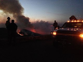
On Friday, April 16, 2016, a 200-acre (81 ha) forest fire was first reported in Shenandoah National Park in the U.S. state of Virginia. The fire originated in the area around Rocky Mount, a mountain in the south district of the park, in a remote region south of Elkton, Virginia. The fire was west of Skyline Drive, the scenic byway that runs through the park. By April 17, the fire had spread to over 500 acres (200 ha), prompting closures of Skyline Drive from mile markers 65 at Swift Run Gap to 79 at Loft Mountain. Additionally, more than a dozen hiking trails were closed, including a section of the Appalachian Trail. By Monday April 18, officials reported that the fire had spread to over 2,000 acres (810 ha) and that a Type 1 incident management team and several hotshot firefighting crews had been dispatched to address the situation. By Wednesday April 20, more than 200 firefighters were on scene or en route, supported by two helicopters carrying water buckets and eight fire engines. National Park Service officials reported on the morning of April 20 that the fire had spread to 4,000 acres (1,600 ha) and that 250 firefighting personnel were engaged in establishing firelines in an effort to control the blaze. By that evening, officials had reported that the fire had expanded to roughly 5,616 acres (2,273 ha) and that at mile marker 76 on Skyline Drive, the fire had crossed the road and burned another 80 to 100 acres. The fire was only 1 percent contained and full containment was not anticipated until April 30 because of ongoing weather conditions favoring fire growth. By the evening of Thursday, April 21, the fire had expanded to 7,935 acres (3,211 ha) and more than 300 firefighting and support personnel had been assigned to the fire. The fire expanded to 8,952 acres (3,623 ha) and 342 firefighters were assigned to the fire by the evening of April 22.

The Border Fire was a large wildfire that burned in Potrero, San Diego County, California, as part of the 2016 California wildfire season. The fire was so named due to its proximity to the United States-Mexican border.
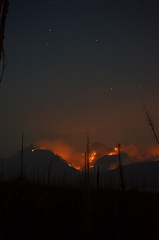
The Sprague Fire was a wildfire in Glacier National Park in Montana. It was first reported on August 10, 2017, around 8:30 pm after being caused by a lightning storm. The fire encompassed 16,982 acres (6,872 ha). It nearly destroyed the historic Sperry Chalet.
The Uno Peak Fire was a wildfire on the slopes of Lake Chelan, approximately 15 miles from Manson, Washington in the United States. The human caused fire was started on August 30, 2017. The fire burned a total of 8,726 acres (35 km2).

The Pawnee Fire was a large wildfire that burned in Spring Valley in Lake County, California, in the United States. The fire started on June 23, 2018, and quickly expanded overnight, destroying 12 structures, and causing the evacuation of the entire Spring Valley area. It destroyed 22 structures, damaged six structures, and burned a total of 15,185 acres (61 km2) before it was fully contained on July 8, 2018. A Cal Fire investigation determined in April 2019 the cause of the fire was target shooting.

The Lions Fire was a wildfire in the Ansel Adams Wilderness in Inyo National Forest and the Sierra National Forest in California in the United States. The fire was started by a lightning strike and first reported on June 11, 2018. The fire impacted recreational activities in both national forests, as well as access to Devils Postpile National Monument. The Lions Fire burned a total of 13,347 acres (54 km2), before burning out on October 1.

The Cranston Fire was a wildfire that burned in southwest Riverside County, California, in the United States. The fire was started on July 25, 2018, by Brandon M. McGlover, in an act of arson. The fire burned a total of 13,139 acres (53 km2), before it was fully contained on August 10. The Cranston Fire impacted the communities of Idyllwild, Mountain Center, and Anza as well as recreational activities in the Lake Hemet area, San Bernardino National Forest and Mount San Jacinto State Park. Over 7,000 people were evacuated due to the Cranston Fire. These communities also went without power for 11 days in 100° temperatures.

The 2020 Loyalton Fire was a large wildfire in Lassen, Plumas and Sierra counties in California and Washoe County in Nevada. After it was ignited by lightning on August 14, 2020, the fire burned 47,029 acres (19,032 ha) in the Tahoe National Forest and the Humboldt-Toiyabe National Forest before it was fully contained on August 26. The Loyalton Fire was notable for generating three fire tornadoes on August 15, necessitating first-of-their-kind warnings by the National Weather Service.

The August 2020 California lightning wildfires were a series of 650 wildfires that ignited across Northern California in mid-August 2020, due to a siege of dry lightning from rare, massive summer thunderstorms, which were caused by an unusual combination of very hot, dry air at the surface, dry fuels, and advection of moisture from the remains of Tropical Storm Fausto northward into the Bay Area. These fires burned between 1,500,000 acres (6,100 km2) to 2,100,000 acres (8,500 km2) within a 2–3 week period. The August 2020 lightning fires included three enormous wildfires: the SCU Lightning Complex, the August Complex, and the LNU Lightning Complex. On September 10, 2020, the August Complex set a record for the single-largest wildfire in the modern history of California, reaching a total area burned of 471,185 acres (1,907 km2). On September 11, the August Complex merged with the Elkhorn Fire, another massive wildfire of 255,039 acres (1,032 km2), turning the August Complex into a monster wildfire of 746,607 acres (3,021 km2).

The Cameron Peak fire was a wildfire that started near Chambers Lake, Colorado, 25 miles (40 km) east of Walden and 15 miles (24 km) southwest of Red Feather Lakes near Cameron Pass on August 13, 2020, and was declared 100% contained on December 2, 2020. The fire burnt 208,663 acres through the Arapaho and Roosevelt National Forests in Larimer and Jackson Counties and Rocky Mountain National Park. At its peak, the fire forced the evacuation of over 6,000 residents in Estes Park, Chambers Lake, Rustic, Glacier View Meadows, Red Feather Lakes, Masonville, Glen Haven, Spring Canyon, various small communities along Highway 14, Stove Prairie Landing Road, as well as the Colorado State University Mountain Campus and had over 1,000 personnel fighting the fire. 469 structures were destroyed by the fire, including 220 outbuildings and 42 primary residences. The fire became the largest wildfire in Colorado history, surpassing the Pine Gulch Fire, which had set the same mark just seven weeks prior.

The Antelope Fire was a large wildfire that burned in the Klamath National Forest, the Modoc National Forest, the Shasta-Trinity National Forest, and in Lava Beds National Monument in Siskiyou County, California, in the United States. The fire was started by a lightning strike and was first reported on August 1, 2021. As of October 15, the fire had burned 145,632 acres (58,935 ha).

The 2020 Maricopa County wildfires were a series of major and non-major wildfires that took place in Maricopa County, Arizona, from the month of May to the month of October. In the year 2020, Arizona saw one of its worst fire seasons in the states history. Due to the lack of precipitation needed in Arizona, the state fell into an ongoing drought from late 2020 and 2021. High winds were also present during the summer when fire season is mostly active in the state. These factors led to the wildfires in Maricopa County to be destructive and costly.

The Border 32 Fire was a destructive wildfire that burned amid the 2022 California wildfire season, in the Barrett Junction area along Highway 94 due north of the United States-Mexican border in San Diego County, California during a statewide heatwave. The fire started on August 31, 2022, and proceeded to destroy ten structures and eventually grow to 4,456 acres (1,803 ha) within the rugged chaparral-dense hillsides throughout the area.

The 2012 Reading Fire was a large wildfire in Lassen Volcanic National Park and the Lassen National Forest in Northern California. Ignited by a lightning strike on July 23, the fire was managed for ecological benefits by park officials until shifts in the weather caused the fire to jump its intended control lines. The Reading Fire ultimately burned 28,079 acres, partially outside the park, before it was fully contained on August 22, 2012. The fire destroyed no buildings and caused no fatalities or even serious injuries. The fire's unintended escape led members of the public and several California politicians to criticize park officials for allowing the fire to go unsuppressed after its discovery.