2014 Washington wildfires

Last updated • 4 min readFrom Wikipedia, The Free Encyclopedia

2014 Washington wildfires
2014 Carlton Complex WA National Guard.jpg
The Carlton Complex on July 21, 2014
Statistics [1]
Total fires1,480
Total area386,972 acres (1,566 km2)
Impacts
Deaths1
Structures destroyed300
Season
2015  

The 2014 Washington wildfires were a series of 1,480 wildfires that burned 386,972 acres (1,566 km2) over the course of 2014. [1] The first occurred primarily on the east side of the Cascade Range in Chelan and Okanogan counties.[ citation needed ] The fires burned private land, state land, and within the Okanogan and Wenatchee National Forests, ultimately covering over 350,000 acres (550 sq mi; 1,400 km2). The first fire began on July 8 near the Entiat River. On July 14 a lightning storm started dozens more fires across the eastern Cascade Range. [2] Governor Jay Inslee declared a state of emergency, activating the Washington National Guard. [3] More lightning strikes later in the summer started additional fires.

Contents

Mills Canyon fire

The Mills Canyon fire burned 22,571 acres (35.3 sq mi; 91.3 km2), all within Chelan County. The fire was located south of the Entiat River and west of U.S. Route 97A and the Columbia River in the Entiat Mountains. It started on July 8 and the cause is under investigation. [2]

July 14 lightning-strike fires

Satellite image of smoke plumes, July 18, 2014 MODIS Washington wildfires 7 18 2014.jpg
Satellite image of smoke plumes, July 18, 2014

A number of fires were started by lightning strikes on July 14.

Carlton Complex

Carlton complex fire scar in false-color infrared, July 31, 2014. Burned vegetation appears red, and the most severely burned areas are generally the darkest. Unburned forests appear dark green. Actively growing farmland is bright green; unburned grasslands and brushlands are tan; and rivers are navy blue. Scale bar at lower left is 5km (3 mi.) Carlton complex scar IR 2014-212.jpg
Carlton complex fire scar in false-color infrared, July 31, 2014. Burned vegetation appears red, and the most severely burned areas are generally the darkest. Unburned forests appear dark green. Actively growing farmland is bright green; unburned grasslands and brushlands are tan; and rivers are navy blue. Scale bar at lower left is 5km (3 mi.)
Weeks after a wildfire in 2014 destroyed much of the town of Pateros, this was all that remained of several blocks that were burned down to the foundations. Pateros Washington 2014 Fire.jpg
Weeks after a wildfire in 2014 destroyed much of the town of Pateros, this was all that remained of several blocks that were burned down to the foundations.

The Carlton Complex, covering 256,108 acres (400.2 sq mi; 1,036 km2), began as four separate lightning-caused fires on July 14 in the Methow River valley of Okanogan County: the Cougar Flat, French Creek, Gold Hike, and Stokes fires. These fires merged and rapidly spread southeast on July 17, burning approximately 300 homes in and around the towns of Pateros and Malott as well as in more rural areas. [4] The communities of Brewster, Carlton, and Methow were also threatened by fire. Power was lost to the communities of Twisp and Winthrop. Road closures included State Route 20 east of Twisp towards Loup Loup Pass, State Route 153 between Twisp and Pateros, and U.S. Route 97 between Pateros and Brewster. [5] [6] Rain slowed the fire on July 24, allowing crews to reach 60% containment by July 26. [7] A new fire started along State Route 20 south of Winthrop on August 1. [6]

The Carlton Complex was the largest wildfire in Washington state's recorded history, surpassing the 1902 Yacolt Burn. [8] One death, caused by a heart attack, has been blamed on the fire. [8] Fire fighting efforts included nearly 3,000 personnel and numerous aircraft, including seven UH-60 Black Hawk helicopters from the Washington National Guard and a DC-10 Air Tanker. [7]

Chiwaukum Creek fire

Located northwest of Leavenworth in the Chiwaukum Mountains, this fire burned 13,895 acres (21.7 sq mi; 56.2 km2). It required the closure of U.S. Route 2 and the evacuation of nearly 900 homes, threatening the communities of Coles Corner, Winton, and Plain. [5] [9] A pyrocumulus cloud could be seen rising above the fire from as far away as Seattle. [3] Part of the Chiwaukum Creek Fire burned within the northeastern boundary of the Alpine Lakes Wilderness.

Duncan fire

Covering 12,659 acres (20 sq mi; 51 km2), the Duncan fire was located in the upper Entiat River drainage. It began on a ridge between the Entiat River and the North Fork Entiat River, eventually spreading east across the North Fork. [9] [10] [11]

Kelly Mountain fire

Located in the Entiat Mountains near Tommy Creek, the Kelly Mountain fire burned 124 acres (0.2 sq mi; 0.5 km2). [9]

Lone Mountain fire

Located in the Boulder Creek drainage northeast of Stehekin, the Lone Mountain fire burned 2,770 acres (4.3 sq mi; 11 km2). It was within the Lake Chelan National Recreation Area, part of the North Cascades National Park Complex. [12] [13]

August 2 lightning-strike fires

South Cle Elum Ridge fire

This fire was reported on August 7 on the Wenatchee National Forest southwest of Cle Elum in Kittitas County and burned 894 acres (1.4 sq mi; 3.6 km2). [19]

Related Research Articles

<span class="mw-page-title-main">Okanogan County, Washington</span> County in Washington, United States

Okanogan County is a county located in the U.S. state of Washington along the Canada–U.S. border. As of the 2020 census, the population was 42,104. The county seat is Okanogan, while the largest city is Omak. Its area is the largest in the state.

<span class="mw-page-title-main">Okanogan–Wenatchee National Forest</span> Protected area in the U.S. state of Washington

The Okanogan–Wenatchee National Forest is a U.S. National Forest located in Okanogan County in north-central Washington, United States.

<span class="mw-page-title-main">Wenatchee National Forest</span> Protected area in the United States

Wenatchee National Forest is a U.S. National Forest located in Washington. With an area of 1,735,394 acres, it extends about 137 miles along the eastern slopes of the Cascade Range of Washington, USA from Okanogan National Forest to Gifford Pinchot National Forest. The forest is located in Chelan, Kittitas and Yakima counties.

<span class="mw-page-title-main">2009 California wildfires</span>

The 2009 California wildfires were a series of 9,159 wildfires that were active in the US state of California, during the year 2009. The fires burned more than 422,147 acres of land from early February through late November, due to Red Flag conditions, destroying hundreds of structures, injuring 134 people, and killing four. The wildfires also caused at least US$134.48 million in damage. Although the fires burned many different regions of California in August, the month was especially notable for several very large fires which burned in Southern California, despite being outside of the normal fire season for that region.

<span class="mw-page-title-main">Thirtymile Fire</span> 2001 fire in the Okanogan National Forest, Washington state

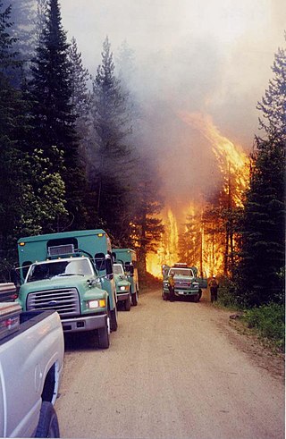
The Thirtymile Fire was first reported on July 9, 2001 in the Okanogan National Forest, approximately 30 miles (48 km) north of Winthrop, Washington, United States. The wildfire had been caused by an unattended campfire that spread rapidly in the hot and dry weather in the Pacific Northwest. Four firefighters were killed when the fire cut off their only escape route out of the narrow canyon.

<span class="mw-page-title-main">2012 Washington wildfires</span>

The 2012 Washington wildfires were a series of 1,342 wildfires that burned 259,526 acres (1,050 km2) over the course of 2012. The fires primarily occurred in the Okanogan and Wenatchee National Forests during September and October 2012. A severe lightning storm on September 8 caused hundreds of fires across the east side of Cascade Range. Smoke caused hazardous air quality conditions in the cities of Ellensburg and Wenatchee, and was noticeable in Seattle. The cost of fighting the largest four fires was estimated to be $67.5 million.

<span class="mw-page-title-main">2013 Colorado wildfires</span>

In the summer of 2013, there were several major wildfires in Colorado in the United States. During June and July, record high temperatures and dry conditions fueled the fires all across the state. By July 24, 570 structures had been destroyed and 2 people died. Below is a list of the major fires of the year.

<span class="mw-page-title-main">West Fork Complex</span>

The West Fork Complex was a complex of wildfires near Wolf Creek Pass in southern Colorado. The first fire, the West Fork fire, was started by lightning at about 1 PM on June 5, 2013. All three fires were started by lightning. As the fire moved into heavy dead timber in early June, thousands of firefighters struggled to prevent movement of the fires into populated areas.

<span class="mw-page-title-main">Rush Fire</span> 2012 wildfire in California and Nevada

The Rush Fire was the largest wildfire of the 2012 California wildfire season. The fire, which started in Lassen County, California, eventually spread into Washoe County, Nevada. The fire consumed a total of 315,577 acres of sagebrush, of which 271,991 acres were in California. At the time, the burn area in California made the Rush Fire the second-largest wildfire in California since 1932. In December 2017, the Thomas Fire surpassed the Rush Fire to become the second-largest wildfire in modern California history, in terms of the area burned in California. In mid-August 2018, the Ranch Fire in the Mendocino Complex Fire surpassed the total acreage of the Rush Fire in both California and Nevada.

<span class="mw-page-title-main">2015 Washington wildfires</span>

The 2015 wildfire season was the largest in Washington state history, with more than one million acres burning across the state from June to September. As many as 3,000 firefighters including 800 Washington National Guard members were deployed to fight the fires. The 17th Field Artillery Brigade of the United States Army also deployed 200 soldiers from Joint Base Lewis–McChord to help fight the fires.

<span class="mw-page-title-main">Carlton Complex Fire</span> 2014 wildfire in Washington state, US

The Carlton Complex Fire was a massive wildfire in north central Washington which burned 256,108 acres (1,036.4 km2) during the 2014 Washington wildfire season. It began on July 14, 2014, as four separate lightning-caused fires in the Methow Valley which merged into one by July 18. The complex destroyed 353 homes in and around the towns of Pateros and Brewster, as well as rural Okanogan County. The fire caused an estimated $98 million in damages. The Carlton Complex remains the largest single wildfire in Washington state history, surpassing the 1902 Yacolt Burn.

<span class="mw-page-title-main">Okanogan Complex Fire</span> 2015 wildfire in Washington, United States

The Okanogan Complex Fire was a wildfire affecting Okanogan County in north-central Washington state. It was composed of five fires that were caused by lightning strikes on August 15, 2015, with two of the fires near Conconully merging days later on August 19. At its peak, it burned over 304,782 acres (123,341 ha) of land and forced the evacuations of numerous towns, including Conconully, Twisp and Winthrop. Over 1,250 firefighters were deployed to the Okanogan Complex. Three United States Forest Service firefighters were killed in an accident near Twisp on August 19. Traditional methods of containing such wildfires, such as creating bulldozer lines, were not readily available due to the irregular terrain and because an inversion layer trapped smoke in the valley, making it difficult to fly in water by helicopter.

<span class="mw-page-title-main">Pier Fire</span> 2017 wildfire in Central California

The Pier Fire was a wildfire that burned near Springville and in the Sequoia National Forest, in California in the United States. The fire was reported on August 29, 2017. The cause of the fire is under investigation, but is believed to be human-caused. The fire was completely extinguished on November 29, after it had burned 36,556 acres (148 km2). The fire threatened old growth sequoia trees, the Tule River Indian Reservation, and many small communities in the area.

The Uno Peak Fire was a wildfire on the slopes of Lake Chelan, approximately 15 miles from Manson, Washington in the United States. The human caused fire was started on August 30, 2017. The fire burned a total of 8,726 acres (35 km2).

<span class="mw-page-title-main">North Complex Fire</span> 2020 wildfire in Northern California

The North Complex Fire was a massive wildfire complex that burned in the Plumas National Forest in Northern California in the counties of Plumas and Butte. 21 fires were started by lightning on August 17, 2020; by September 5, all the individual fires had been put out with the exception of the Claremont and Bear Fires, which merged on that date, and the Sheep Fire, which was then designated a separate incident. On September 8, strong winds caused the Bear/Claremont Fire to explode in size, rapidly spreading to the southwest. On September 8, 2020, the towns of Berry Creek and Feather Falls were immediately evacuated at 3:15 p.m. PDT with no prior warning. By September 9, 2020, the towns of Berry Creek and Feather Falls had been leveled, with few homes left standing. The fire threatened the city of Oroville, before its westward spread was stopped. The fire killed 16 people and injured more than 100. Among the 16 fatalities was a 16-year-old boy. The complex burned an estimated 318,935 acres (129,068 ha), and was 100% contained on December 3. The fire was managed by the U.S. Forest Service in conjunction with Cal Fire, with the primary incident base in Quincy. The North Complex Fire is the eighth-largest in California's history, and was the deadliest fire in the 2020 California wildfire season.

<span class="mw-page-title-main">2020 Western United States wildfire season</span>

The Western United States experienced a series of major wildfires in 2020. Severe August thunderstorms ignited numerous wildfires across California, Oregon, and Washington, followed in early September by additional ignitions across the West Coast. Fanned by strong, gusty winds and fueled by hot, dry terrains, many of the fires exploded and coalesced into record-breaking megafires, burning more than 10.2 million acres of land, mobilizing tens of thousands of firefighters, razing over ten thousand buildings, and killing at least 37 people. The fires caused over $19.884 billion in damages, including $16.5 billion in property damage and $3.384 billion in fire suppression costs. Climate change and poor forest management practices contributed to the severity of the wildfires.

Myrtle Lake is a freshwater lake located on the northern slope of Rampart Mountain East of Cow Creek Meadows, in Chelan County, Washington. Self-issued Alpine Lake Wilderness permit required for transit within the Glacier Peak Wilderness area. Because Myrtle Lake is at the heart of the Alpine Lakes Wilderness, the lake is a popular area for hiking, swimming, and fishing brook trout.

The 2021 Washington wildfire season officially began in March 2021. By late April, all of Eastern Washington had been classified by the United States Drought Monitor as "abnormally dry" with moderate to severe drought conditions. The state had more than 630 wildfires by the first week of July, on par with the state's record 2015 wildfire season.

<span class="mw-page-title-main">2024 Washington wildfires</span> An overview of major wildfires in Washington during the year 2024

The 2024 Washington wildfire season is an ongoing series of wildfires that have been burning throughout the U.S. state of Washington.

References

  1. 1 2 "2014 year-end fire statistics" (PDF). National Interagency Fire Center . Archived from the original (PDF) on June 28, 2018. Retrieved September 3, 2015.
  2. 1 2 "Mills Canyon Fire". InciWeb: Incident Information System. Archived from the original on July 18, 2014. Retrieved July 18, 2014.
  3. 1 2 "Wildfire near Leavenworth closes stretch of Highway 2". Seattle Times and wire services. YakimaHerald.com. July 17, 2014. Archived from the original on August 8, 2014. Retrieved July 19, 2014.
  4. "Homes destroyed by wildfire total 300, Okanogan sheriff says". The Associated Press. The Seattle Times. July 25, 2014. Archived from the original on August 11, 2014. Retrieved July 27, 2014.
  5. 1 2 Geranios, Nicholas K.; Johnson, Gene (July 19, 2014). "Damage from Washington Wildfires 'Hard to Believe'". The Associated Press. Boston.com. Archived from the original on July 27, 2014.
  6. 1 2 "Carlton Complex". InciWeb: Incident Information System. Archived from the original on August 12, 2015. Retrieved July 21, 2014.
  7. 1 2 "Crews plan controlled burn near Carlton complex wildfire". The Seattle Times. July 26, 2014. Archived from the original on August 11, 2014.
  8. 1 2 O'Sullivan, Joseph (July 21, 2014). "Firefighting crews hunker down for long haul". The Seattle Times. Archived from the original on July 22, 2014.
  9. 1 2 3 4 5 "Chiwaukum Complex". InciWeb: Incident Information System. Archived from the original on July 5, 2015. Retrieved July 21, 2014.
  10. "Fire Update for Mills Canyon, Chiwaukum, Kelly MT n, & Duncan Fires". InciWeb: Incident Information System. July 19, 2014. Archived from the original on July 21, 2014.
  11. "Duncan Fire". InciWeb: Incident Information System. Archived from the original on August 10, 2014. Retrieved August 9, 2014.
  12. "Lone Mountain Fire Update—July 21st a.m." North Cascades National Park, U.S. National Park Service. July 21, 2014. Retrieved July 21, 2014.
  13. "Lone Mountain 1 Fire". InciWeb: Incident Information System. Archived from the original on July 26, 2014. Retrieved July 21, 2014.
  14. "Devil's Elbow Complex". InciWeb: Incident Information System. Archived from the original on August 15, 2014. Retrieved August 16, 2014.
  15. "Little Bridge Creek Fire". InciWeb: Incident Information System. Archived from the original on August 7, 2014. Retrieved August 6, 2014.
  16. "Snag Canyon Fire". InciWeb: Incident Information System. Archived from the original on August 8, 2014. Retrieved August 3, 2014.
  17. Rosbach, Molly (August 3, 2014). "Snag Canyon fire destroys 6 homes; area reduced to 1,830 acres". Yakima Herald-Republic. Archived from the original on August 5, 2014. Retrieved August 4, 2014.
  18. "Upper Falls Fire". InciWeb: Incident Information System. Archived from the original on August 9, 2014. Retrieved August 6, 2014.
  19. "South Cle Elum Ridge Fire". InciWeb: Incident Information System. Archived from the original on August 10, 2014. Retrieved August 8, 2014.

Further reading