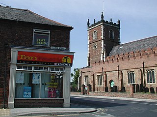
Colden Parva

Last updated

Colden Parva (Little Cowden)
Ecclesiastical parish
East Riding of Yorkshire UK location map.svg
Red pog.svg
Colden Parva (Little Cowden)
Location within the East Riding of Yorkshire
Shire county
Region
Country England
Sovereign state United Kingdom
List of places
UK
England
Yorkshire
53°50′42″N0°04′59″W / 53.845°N 0.083°W / 53.845; -0.083

Colden Parva (also known as Little Cowden) is a former village and ecclesiastical parish of the East Riding of Yorkshire that was lost due to coastal erosion in the 17th century. The name persisted as part of the ecclesiastical parish covering nearby Aldbrough until into the 1970s.

Contents

History

The village of Little Cowden is recorded in the Domesday Book as being one of the smallest populated places in the Domesday record. [1] The village of Little Cowden is listed as having seven houses in 1401, and was being occupied until 1517, when it was largely deserted. [2] Church records show that 24 persons were evicted on the orders of St Mary's Abbey in York. [3] Although some farmsteads continued in the area, most of the land in the parish and village had been lost to coastal erosion. [4] The village is recorded as being "swept away by the sea" in 1690, but the church had been lost as early as 1627. [5] [6] The area became the property of the Ros family, then the le Despenser family, and finally the Wentworths. [7]

Little Cowden/Colden Parva was listed as a village as it had a church dedicated to St John the Evangelist. [8] The presence of the church and the link in religious terms to the ecclesiastical parish of Aldbrough, meant that the name of the village was still listed in the 1970s. The York Diocesan Yearbook for 1975 has an entry for "Aldbrough, St Bartholomew, with Colden Parva, St John the Evangelist (now in the sea)." [9] As a few acres of the parish still existed on dry land, churchwardens were still being elected to the defunct church in the 1970s due to an act dating back to the 13th century. [5]

Parts of the old parish were still extant in the 19th and 20th centuries, with the ecclesiastical parish covering an area of 728 acres (295 ha) in 1852, however, the loss rate of land due to coastal erosion was listed as being 3.8 yards (3.5 m) a year. [10] [11] What remained of Colden Parva in 1892 was two farms under its other name of Little Cowden. [12] The western area of what remained of the parish became part of the Cowden military range, but this was closed in the early 21st century, and most of what was left of Colden Parva/Little Cowden had been washed away by 2009. [13]

See also

Related Research Articles

<span class="mw-page-title-main">Mappleton</span> Village and civil parish in the East Riding of Yorkshire, England

Mappleton is a village and civil parish in the East Riding of Yorkshire, England. It is situated on the North Sea coastline in an area known as Holderness, lying approximately 3 miles (5 km) south of the seaside resort of Hornsea. The civil parish is formed by the village of Mappleton and the hamlets of Cowden, Great Cowden and Rolston. According to the 2011 UK census, Mappleton parish had a population of 342, an increase on the 2001 UK census figure of 249.

<span class="mw-page-title-main">Harpham</span> Village and civil parish in the East Riding of Yorkshire, England

Harpham is a small village and civil parish in the East Riding of Yorkshire, England. It is located just south of the A614 road, approximately 5 miles (8 km) north-east of Driffield and 7 miles (11 km) south-west of Bridlington.

<span class="mw-page-title-main">Aldbrough, East Riding of Yorkshire</span> Village and civil parish in the East Riding of Yorkshire, England

Aldbrough is a village and civil parish in the East Riding of Yorkshire, England, about 12 miles (19 km) north-east of Hull at the junction of the B1242 and B1238 roads. It lies near to the North Sea coast within the area of Holderness.

<span class="mw-page-title-main">Barmston, East Riding of Yorkshire</span> Village in the East Riding of Yorkshire, England

Barmston is a village and civil parish in the East Riding of Yorkshire, England. It is situated on the Holderness coast, overlooking the North Sea and to the east of the A165 road. Barmston is approximately 6 miles (10 km) south of Bridlington town centre. The parish includes the village of Fraisthorpe, the former villages of Auburn and Hartburn have been abandoned due to coastal erosion. Barmston is mentioned in the Domesday Book as having eight ploughlands and belonging to Drogo of la Beuvrière. The name of the village derives from Beorn's Tūn. According to the 2011 UK census, Barmston and Fraisthorpe parish had a population of 275, a slight decrease on the 2001 UK census figure of 277. The parish covering an area of 1,765.014 hectares.

<span class="mw-page-title-main">Thorganby, North Yorkshire</span> Village and civil parish in North Yorkshire, England

Thorganby is a small village and civil parish in North Yorkshire, England. It was historically part of the East Riding of Yorkshire until 1974, but from 1974 to 2023 was in the Selby District of the shire county of North Yorkshire. In 2023 the district was abolished and North Yorkshire became a unitary authority.

<span class="mw-page-title-main">North Otterington</span> Village and civil parish in North Yorkshire, England

North Otterington is a civil parish with no village centre on the east bank of the River Wiske, in the Hambleton District of North Yorkshire, England. North Yorkshire County Council estimated its population in 2011 to be 40 and 30 in 2015. Details are also included in the civil parish of Ainderby Steeple. It is on the A167 road 3 miles (4.8 km) south of Northallerton; South Otterington is further south on the same road.

<span class="mw-page-title-main">Catwick</span> Village and civil parish in the East Riding of Yorkshire, England

Catwick is a village and civil parish in the East Riding of Yorkshire, England. It is situated approximately 7.5 miles (12 km) north-east of Beverley town centre and 5 miles (8 km) west of Hornsea town centre. It lies on the A1035 road from Leven to Hornsea.

<span class="mw-page-title-main">Holmpton</span> Village and civil parish in the East Riding of Yorkshire, England

Holmpton is a village and civil parish in the East Riding of Yorkshire, England, in an area known as Holderness. It is situated approximately 3 miles (5 km) south of Withernsea town centre and 3 miles (5 km) east of the village of Patrington. It lies just inland from the North Sea coast.

<span class="mw-page-title-main">Cowden, East Riding of Yorkshire</span> Hamlet in the East Riding of Yorkshire, England

Cowden is a hamlet in the East Riding of Yorkshire, England, in an area known as Holderness. It is situated approximately 5 miles (8 km) south of Hornsea and lies just east of the B1242 road towards the North Sea coast. Its name means a hill where charcoal was burnt.

<span class="mw-page-title-main">Dickering Wapentake</span> Former administrative division of Yorkshire, England

Dickering was a wapentake of the historic East Riding of Yorkshire in England, consisting of the north-east part of that county, including the towns of Bridlington and Filey; its territory is now partly in the modern East Riding and partly in North Yorkshire. It was established in 12th or 13th century by combining the three ancient Domesday hundreds of Burton, Huntou (Hunthow) and Torbar. The Wapentake of Dickering ceased to have much significance in the 19th century when the wapentakes were superseded by other administrative divisions for most local government purposes.

<span class="mw-page-title-main">Muston, North Yorkshire</span> Village and civil parish in North Yorkshire, England

Muston is a village and civil parish, in North Yorkshire, England. It was historically in the East Riding of Yorkshire. The village is situated 1.5 miles (2.4 km) south-west from the centre of the coastal town of Filey, and on the A1039 road.

<span class="mw-page-title-main">Flixton, North Yorkshire</span> Village in North Yorkshire, England

Flixton is a village in North Yorkshire, England. Until 1974 the village lay in the historic county boundaries of the East Riding of Yorkshire and from 1974 to 2023 it was part of the Borough of Scarborough. There is a public house, the Foxhound Inn.

<span class="mw-page-title-main">East Hardwick</span> Village and civil parish in West Yorkshire, England

East Hardwick is a village and civil parish in the City of Wakefield in West Yorkshire, England. It has a population of 191, reducing to 173 at the 2011 Census. Until 1974 it was part of Osgoldcross Rural District.

<span class="mw-page-title-main">Mickley, North Yorkshire</span> Village in North Yorkshire, England

Mickley is a village in the Harrogate District of North Yorkshire, England. The village is on the south bank of the River Ure between Masham and West Tanfield.

<span class="mw-page-title-main">Church of All Saints, Skipsea</span> Anglican church in the East Riding of Yorkshire, England

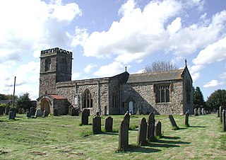
The Church of All Saints, is the church for the village and parish of Skipsea, in the East Riding of Yorkshire, England. The church dates back to the late 11th/early 12th century and was the religious house tied to Skipsea Castle, which lay just to the west in Skipsea Brough. A causeway, to the north of the church, used to link it with the castle motte across what was Skipsea Bail Mere. The village continued developing long after the castle had been demolished c. 1221, and the church became the house of worship for Skipsea.

<span class="mw-page-title-main">Coastal erosion in Yorkshire</span> Erosion of the Yorkshire coastline, England

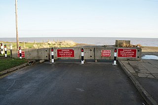
Coastal erosion in Yorkshire has been a process that has been documented since Roman times. Rates of erosion on the Holderness coast are known to be the worst within Europe, with the East Riding coastlines having the greatest number of at risk properties in England. Almost 30 settlements on the Holderness coastline have been lost to the sea, with more being subjected to flooding and loss exacerbated by a projected rise in the sea level caused by climate change. Due to the limited protection from effects of rising seas in the Humber Estuary, the region has the greatest value of assets at risk from flooding than anywhere else in England.

<span class="mw-page-title-main">Argam</span> Former parish in the East Riding of Yorkshire, England

Argam, or Argham, was a civil parish and village in the East Riding of Yorkshire, England. The site is listed in many historical documents, but was deserted by the early 19th century, now being part of the civil parish of Grindale. The village was depopulated, becoming one of the known deserted Medieval villages in Yorkshire.

<span class="mw-page-title-main">Henderskelfe</span> Civil parish in North Yorkshire, England

Henderskelfe is a civil parish in North Yorkshire, England. The parish does not contain any villages, though it is named after a previous settlement and castle which occupied the land on which Castle Howard is now built. Historically the area was a township in the ecclesiastical parish of Bulmer, however it has been its own civil parish since 1866.

<span class="mw-page-title-main">Church of the Ascension, Whixley</span> Anglican church in North Yorkshire, England

The Church of the Ascension is an Anglican church in the village of Whixley, North Yorkshire, England. Whilst the Domesday Book entry for Whixley mentions the presence of a church, the main fabric of the existing church dates to the 14th century. Up until it was renovated in the 19th century, it was dedicated to St James, but was rededicated as the Church of the Ascension, and it is now a grade II* listed building. Nikolaus Pevsner notes that it is unusual for a village church to be composed of mostly the same style of architecture (Decorated).

<span class="mw-page-title-main">Lambwath Stream</span> Stream in the East Riding of Yorkshire, England

Lambwath Stream, is a small beck in the Holderness area of the East Riding of Yorkshire, England. The stream is unusual in that despite rising only metres away from the coast, it runs inland (westwards) for nearly 19 kilometres (12 mi) into the Holderness Drain. The watercourse was heavily modified during Medieval times to act as a drain.

References

  1. "[Little] Cowden | Domesday Book". opendomesday.org. Retrieved 30 August 2023.
  2. Fletcher 2002, p. 310.
  3. Beresford, Maurice Warwick (1963) [1954]. The lost villages of England. London: Lutterworth Press. p. 304. OCLC   1194441244.
  4. "Little Cowden". heritagegateway.org.uk. Retrieved 30 August 2023.
  5. 1 2 Russel, Stuart (31 July 1975). "Owthorne and the final tragedy, and the last days of Colden Parva". Hull Daily Mail. No. 27, 909. p. 8. ISSN   1741-3419.
  6. Sheppard, Thomas (1912). The Lost Towns of the Yorkshire Coast. Hull: Brown & Sons. p. 162. OCLC   613711266.
  7. Fletcher 2002, p. 312.
  8. Whellan, T. (1856). History and topography of the City of York and the Ainsty wapentake and the East Riding of Yorkshire. Beverley: Sheahan & Whellan. p. 425. OCLC   23461588.
  9. "Wardens of a church which doesn't exist". Hull Daily Mail. No. 27, 822. 21 April 1975. p. 6. ISSN   1741-3419.
  10. Fletcher 2002, p. 306.
  11. Reid, Clement (1885). The Geology of Holderness, and the Adjoining Parts of Yorkshire and Lincolnshire. London: HMSO. p. 96.
  12. "Genuki: Mappleton Parish information from Bulmers' 1892., Yorkshire (East Riding)". genuki.org.uk. Retrieved 30 August 2023.
  13. "Rapid coastal zone assessment survey; Bempton to Donna Nook phase 2 part 2". historicengland.org.uk. p. 105. Retrieved 1 September 2023.

Sources