Collegio Ghislieri (Rome)

Last updated
Collegio Ghislieri
Facciata Liceo Virgilio.jpg
The facade of the Ghislieri College incorporated in the Liceo Virgilio
Collegio Ghislieri (Rome)
General information
Location Rome, Italy

The Collegio Ghislieri was a building in Rome, seat of the eponymous charitable institution, important for architectural and historical reasons.

Contents

The College was founded in 1656 by Giuseppe Ghislieri and was meant to host 24 boys of the decayed pontifical nobility for free during high school. Placed under the protection of the duke Salviati, the college was closed in 1928.

The building which hosted the college, possibly work of Carlo Maderno, was demolished in the 1930s. Its façade on Via Giulia and some decorations have survived, incorporated in the structure of the Liceo classico Virgilio, built on the same site between 1936 and 1939 after a design by Marcello Piacentini.

Location

The building was located in Rome, in the Regola Rione, about halfway down via Giulia (at the n. 38), [1] in an area devastated by the demolitions started in 1938 for the construction of a road between Ponte Mazzini and Corso Vittorio Emanuele, never built because of the war. To the south it bordered with vicolo dello struzzo. [2]

History

In 1656 Giuseppe Ghislieri (1570–1656), a renowned physician and member of the family to which Pope Pius V (r. 1566–1572) had belonged, on his deathbed destined all his goods to the foundation of this institution. [3] [2] In 1670, after being housed in various locations (at the Botteghe Oscure in front of Santo Stanislao dei Polacchi, in Via della Stamperia by Palazzo Pamphilj and at Via della Lupa), the Collegio moved to its final seat at via Giulia, [2] in a 16th century palace possibly designed by Carlo Maderno. [4] [5] The institution was administered by four guardiani of the Archconfraternity of the Sancta Sanctorum by the holy stairs, [6] and was placed under the protection of the noble Florentine family of the Salviati. [2]

When the Salviati family died out in 1794, protectors became several cardinals, including Francesco Carafa della Spina di Traetto and Joseph Fesch, uncle of Napoleon and resident not far away, at Palazzo Falconieri in Via Giulia. [2] In 1839 the third-born son of the prince Borghese took the name of the Salviati, thus regaining the protectorate of the college. [2] The institution was closed in 1928 because of financial difficulties. [2] Through the proceeds of the liquidation, however, annual scholarships were instituted which allowed to continue the college mission. [2]

Between 1936 and 1939 the building was almost completely demolished to make way for the Liceo classico Virgilio, a controversial work [7] by Marcello Piacentini.

Organization

The boarding school housed for five years 24 young people (later increased to 38) [8] from fallen noble families of the Papal State. [2] Later, the school was opened to young boys of each class. [1] At the time of admission the students had to be not older than 18 years and were lodged for a maximum of five years. [6] [8] Of these, six were hosted free of charge: five of them were designated one each by as many noble families, and the sixth by the Roman people. [2] The students attended the subjects of their choice at the Collegio Romano without any obligation to join the ecclesiastical career, [6] even though they had to wear a long black dress under their knees and a black cassock, and they had to attend daily mass and often take the sacraments. [9] The boys were housed in three dormitories, intended for the younger, the older and the middle ones. [8] The wake up call took place at 5:30 a.m., and after having washed with cold water and followed the lessons at the Collegio Romano, they continued their study in the premises of Via Giulia. [8] After the recreation they had to study until the evening for three hours and a quarter. [8] The discipline was very hard, and for every little lack the students were forced to suffer penances and punishments, such the so called piatto rovesciato (English: overturned dish), that is being at lunch with the overturned dish in silence, therefore fasting. [8]

Architecture and Decoration

The relief portraying the Holy Family placed above the entrance portal Via Giulia Collegio Ghislieri.jpg
The relief portraying the Holy Family placed above the entrance portal

The building, according to some sources, was a 16th century work by Carlo Maderno. [4] It was structured on two floors with a mezzanine on the ground floor, and had a front of ten windows with a portal asymmetrical with respect to the façade. [2] [7] The edifice was almost completely demolished at the end of the 1930s for the construction of the Liceo classico Virgilio. [7] What remained of the old building, including the facade along Via Giulia, [4] was incorporated into the high school building: in particular, at the number 38 of Via Giulia has been remained in place the ancient and imposing portal, surmounted by a curvilinear broken tympanum adorned by a relief representing the Holy Family. [7] Below this, it is placed the coat of arms of the House of Ghislieri, surrounded by the following inscription in a cartouche: [7]

IOSEPH GHISLERIVS PRAE(SE)S AEDIBVS/ PROPRIO AERE COEMPTIS COLLEGIVM FUNDAVIT/ DOTAVIT ET DE COGNOM(INE) COLLEGIVM GHISLERIVM/ NUNCVPARI VOLVIT AC PROTECTIONI DEIPA(RAE) / VIRGINIS MARIAE ET S. JOSEPHI COM(M)ENDAVIT

Giuseppe Ghislieri bought this dwelling at his own expense, founded the college, wanted it to be called Ghislieri from his surname and recommended it to the protection of the Blessed Virgin Mary and St. Joseph

Notable alumni

Related Research Articles

<span class="mw-page-title-main">Regola</span> Rione of Rome in Latium, Italy

Regola is the 7th rione of Rome, Italy, identified by the initials R. VII, and belongs to the Municipio I. The name comes from Arenula, which was the name of the soft sand that the river Tiber left after the floods, and that built strands on the left bank.

<span class="mw-page-title-main">Sant'Angelo (rione of Rome)</span> Rione of Rome in Latium, Italy

Sant'Angelo is the 11th rione of Rome, Italy, located in Municipio I. Often written as rione XI - Sant'Angelo, it has a coat of arms with an angel on a red background, holding a palm branch in its left hand. In another version, the angel holds a sword in its right hand and a scale in its left.

<span class="mw-page-title-main">Borgo (rione of Rome)</span> Rione of Rome in Latium, Italy

Borgo is the 14th rione of Rome, Italy. It is identified by the initials R. XIV and is included within Municipio I.

<span class="mw-page-title-main">Via Giulia</span> Thoroughfare in Rome, Italy

The Via Giulia is a street of historical and architectural importance in Rome, Italy, which runs along the left (east) bank of the Tiber from Piazza San Vincenzo Pallotti, near Ponte Sisto, to Piazza dell'Oro. It is about 1 kilometre long and connects the Regola and Ponte Rioni.

<span class="mw-page-title-main">Santa Maria in Via Lata</span> Church in Rome, Italy

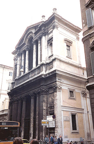
Santa Maria in Via Lata is a church on the Via del Corso, in Rome, Italy. It stands diagonal from the church of San Marcello al Corso.

<span class="mw-page-title-main">Guido Baccelli</span> Italian politician

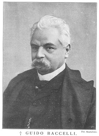
Guido Baccelli was an Italian physician and statesman. One of the most renowned Italian physicians of the late 19th Century, he was Minister of Education of the then young Kingdom of Italy for six times and once Minister of Agriculture, Industry and Commerce, for a total period of almost ten years, between 1881 and 1903. He was a teacher to Augusto Murri. Together with Italian surgeon Francesco Durante, Baccelli promoted the construction of the Policlinico Umberto I in Rome.

The Collegio S. Giuseppe-Istituto de Mérode is a Catholic school of the Brothers of the Christian Schools. It is located in Rome, Italy, in via San Sebastianello 1, at the corner of Piazza di Spagna, in the rione Campo Marzio. It comprises two buildings, the Collegio S. Giuseppe and the Istituto de Mérode.

<span class="mw-page-title-main">Via dei Coronari</span>

Via dei Coronari is a street in the historic center of Rome. The road, flanked by buildings mostly erected in the 15th and the 16th century, belongs entirely to the rione Ponte and is one of the most picturesque roads of the old city, having maintained the character of an Italian Renaissance street.

<span class="mw-page-title-main">Santi Simone e Giuda, Rome</span>

Santi Simone e Giuda is a deconsecrated Catholic church in the center of Rome, Italy. It is important for historical reasons.

<span class="mw-page-title-main">Palazzo dei Convertendi</span> Building in Rome, Italy

Palazzo dei Convertendi is a reconstructed Renaissance palace in Rome. It originally faced the Piazza Scossacavalli, but was demolished and rebuilt along the north side of Via della Conciliazione, the wide avenue constructed between 1936 and 1950, which links St Peter's Basilica and the Vatican City to the centre of Rome. The palace is famous as the last home of the painter Raphael, who died there in 1520.

<span class="mw-page-title-main">San Giacomo Scossacavalli</span> Church in Rome, destroyed in 1937

San Giacomo Scossacavalli was a church in Rome important for historical and artistic reasons. The church, facing the Piazza Scossacavalli, was built during the early Middle Ages and since the early 16th century hosted a confraternity which commissioned Renaissance architect Antonio da Sangallo the Younger to build a new shrine. This was richly decorated with frescoes, painted by mannerist artist Giovanni Battista Ricci and his students. The church was demolished in 1937, when Via della Conciliazione was built and the piazza and central part of the Borgo rione were demolished. Many decorative elements still exist, since they were preserved from demolition.

<span class="mw-page-title-main">Palazzo Rusticucci-Accoramboni</span> Building in Rome, Italy

The Palazzo Rusticucci-Accoramboni is a reconstructed late Renaissance palace in Rome. Erected by the will of Cardinal Girolamo Rusticucci, it was designed by Domenico Fontana and Carlo Maderno joining together several buildings already existing. Due to that, the building was not considered a good example of architecture. Originally lying along the north side of the Borgo Nuovo street, after 1667 the building faced the north side of the large new square located west of the new Saint Peter's Square, designed in those years by Gian Lorenzo Bernini. The square, named Piazza Rusticucci after the palace, was demolished in 1937–40 because of the erection of the new Via della Conciliazione. In 1940 the palace was dismantled and rebuilt with a different footprint along the north side of the new avenue, constructed between 1936 and 1950, which links St Peter's Basilica and the Vatican City to the center of Rome.

<span class="mw-page-title-main">Liceo scientifico statale Camillo Cavour</span> Liceo scientifico school in Rome, Italy

Liceo scientifico statale Camillo Cavour is a liceo scientifico located in Rome, in via delle Carine 1, in Rione Monti. It was the first scientific high school in Rome, and potentially in the whole Italy.

<span class="mw-page-title-main">Borgo Vecchio (Rome)</span> Former road in Rome

Borgo Vecchio, also named in the Middle Ages Via Sancta, Carriera Sancta or Carriera Martyrum, was a road in the city of Rome, Italy, important for historical and architectural reasons. The road was destroyed together with the adjacent quartier in 1936–37 due to the construction of Via della Conciliazione.

<span class="mw-page-title-main">Piazza Scossacavalli</span> Former square in Rome

Piazza Scossacavalli, also named Piazza di San Clemente, Piazza di Trento, Piazza d'Aragona, Piazza Salviati, was a square in Rome, Italy, important for historical and architectonic reasons. The square was demolished together with the surrounding quarter in 1937 due to the construction of Via della Conciliazione.

<span class="mw-page-title-main">Santa Maria della Purità (Rome)</span>

Santa Maria della Purità was a church in Rome, important for historical and artistic reasons. Consecrated between 1530 and 1538, the building was demolished together with the surrounding district in 1937-40 during the works for the opening of via della Conciliazione.

<span class="mw-page-title-main">Pinciano</span> Quartiere of Rome in Lazio, Italy

Pinciano is the 3rd quartiere of Rome (Italy), identified by the initials Q. III. The name derives from the Pincian Hill. It belongs to the Municipio II.

<span class="mw-page-title-main">San Filippo Neri in Via Giulia</span> Church in Rome, Italy

San Filippo Neri is a deconsecrated church in Rome, important for historical and artistic reasons. The church, facing the Via Giulia, was built during the Baroque age. San Filippo was supposed to be demolished together with the surrounding neighborhood in the late 1930s, but due to the onset of WWII the demolition was halted. Abandoned and desecrated after the war, it has been restored in 2000, but maintains a secular usage and is not accessible.

<span class="mw-page-title-main">Carceri Nuove</span> Jail built by Pope Innocent X

The Carceri Nuove was a prison built in the mid-17th century at the instigation of Pope Innocent X and his ideals of humanity and clemency. The New Jails were to replace other prisons throughout the city. This jail remained in operation until the construction of the judicial prison of Regina Coeli in Trastevere at the turn of the 20th century. The building, in 2020, housed the Direzione Nazionale Antimafia e Antiterrorismo.

<span class="mw-page-title-main">Palazzo Sacchetti</span> Palace in Rome, Italy

Palazzo Sacchetti is a palazzo in Rome, important for historical and artistic reasons.

References

  1. 1 2 Borghi (2015), p. 43
  2. 1 2 3 4 5 6 7 8 9 10 11 Pietrangeli (1979), p. 22
  3. Baronio (1697), p. 246
  4. 1 2 3 "La Storia" (in Italian). Liceo Ginnasio Statale "Virgilio". Archived from the original on 26 August 2017. Retrieved 11 April 2020.
  5. Salerno (1973), p. 132
  6. 1 2 3 Baronio (1697), p. 247
  7. 1 2 3 4 5 Pietrangeli (1979), p. 24
  8. 1 2 3 4 5 6 Borghi (2015), p. 44
  9. Borghi (2015), p. 45
  10. Borghi (2015), passim

Sources

Coordinates: 41°53′47.6″N12°28′04.0″E / 41.896556°N 12.467778°E / 41.896556; 12.467778