Related Research Articles
Pine Township is a township in Armstrong County, Pennsylvania, United States. The population was 412 at the 2010 census.
Spry is a census-designated place (CDP) in York County, Pennsylvania, United States. The population was 4,891 at the 2010 census.

Madisonville is a city in Madison County, Texas, United States. The population was 4,420 at the 2020 census. It is the county seat of Madison County. Both the City of Madisonville and the County of Madison were named for U.S. President James Madison, the fourth chief executive.
Northwest Roseau is an unorganized territory in Roseau County, Minnesota, United States. The population was 18 at the 2000 census.

Cabo San Lucas, or simply Cabo, is a resort city at the southern tip of the Baja California Peninsula, in the Mexican state of Baja California Sur. As at the 2020 Census, the population of the city was 202,694 inhabitants. Cabo San Lucas together with San José del Cabo are collectively known as Los Cabos. Together, they form a metropolitan area of 351,111 inhabitants.

Cabo Rojo is a city and municipality situated on the southwest coast of Puerto Rico and forms part of the San Germán–Cabo Rojo metropolitan area as well as the larger Mayagüez–San Germán–Cabo Rojo Combined Statistical Area.

San José del Cabo is a city located in southern Baja California Sur state, Mexico. It is the seat of Los Cabos Municipality lying at a shallow bay 32 kilometres (20 mi) northeast of Cabo San Lucas on the Gulf of California. The city has a population of 136,285 as of the 2020 Census. San José del Cabo together with Cabo San Lucas are known as Los Cabos. Together they form a metropolitan area of 351,111 inhabitants.

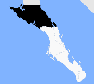
Los Cabos is a municipality located at the southern tip of Mexico's Baja California Peninsula, in the state of Baja California Sur. It encompasses the two towns of Cabo San Lucas and San José del Cabo linked by a thirty-two-km Resort Corridor of beach-front properties and championship golf courses.

Federal Highway 1 is a free (libre) part of the federal highway corridors of Mexico, and the highway follows the length of the Baja California Peninsula from Tijuana, Baja California, in the north to Cabo San Lucas, Baja California Sur, in the south. The road connects with Via Rapida, which merges into the American Interstate 5 (I-5) at the San Ysidro Port of Entry, which crosses the international border south of San Ysidro, California.
Mulegé is the northernmost municipality of the Mexican state of Baja California Sur. It is the largest municipality by area in the state and in Mexico, with an area of 33,092.20 km2. In the 2020 Census, it had a population of 64,022 inhabitants. Isla Natividad is part of the municipality.

The arch of Cabo San Lucas is a distinctive rock formation at the southern tip of Cabo San Lucas, which is itself the extreme southern end of Mexico's Baja California Peninsula. The arch is locally known as "El Arco," which means "the arch" in Spanish, or "Land's End."

Ciudad Constitución is a city in the Mexican state of Baja California Sur. It is the seat of Comondú Municipality. As of 2019, the city had a total population of 45,888 inhabitants. Ciudad Constitución is a small city which serves as a gateway to Magdalena Bay.
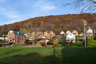
Clarksville is an unincorporated community in Wayne Township, Hamilton County, Indiana. It was likely named in honor of George Rogers Clark, an officer in the American Revolutionary War.

SS Rondo was a steam cargo ship. She was built by Tampa Shipbuilding & Drydock Company of Florida for the British government under the name War Wonder and was launched in 1917. The First World War ended before she entered service and she entered service for the US Shipping Board as the Lithopolis. She was sold to various Norwegian companies, becoming the Laurie, and finally the Rondo in 1934.
Santa Anita is a village in Los Cabos Municipality, Baja California Sur, western Mexico. It is located north of San Jose del Cabo on the right bank of the Arroyo San José along Federal Highway 1. It had a population of 687 inhabitants in the 2010 census, and is situated at an elevation of 76 meters (249 ft.) above sea level.

Campo de Cartagena, also called Campo del Mar Menor, is a natural region (comarca) located in the Region of Murcia, in Spain. For administrative purposes, it is also known, as Comarca del Campo de Cartagena or Comarca de Cartagena. It is located in the southeast of the Iberian Peninsula, forming a plain which extends from the Sierra de Carrascoy to the Mediterranean. The capital city is Cartagena, the most important Naval Base of the Spanish Navy in the Mediterranean Sea.
El Tezal is the new area of Cabo San Lucas, situated near to the Tourist Corridor which connects Los Cabos at an altitude of 30 meters. El Tezal is a residential zone, where have been built developments like Las Villas del Tezal, Palmeira, Rancho Pariaso Estate, Cumbre del Tezal, Toscana Cabos, Las Misiones, La Vista, Ventanas Hotel & Residences, Cabo del Mar and Camino del Mar. The 2010 census reported a population of 878 inhabitants.

Limestone is a census-designated place (CDP) comprising the main village within the town of Limestone in Aroostook County, Maine, United States. The population was 1,075 at the 2010 census, out of a population of 2,314 for the entire town.
Miraflores is a small town in the Municipality of Los Cabos. Miraflores is located about 45 miles north of San Jose del Cabo, 2 km west of Highway 1, just to the east of the Sierra de la Laguna. Miraflores is 220 meters above sea level. As of 2010, the town had a population of 1,384.

Lomovka is a rural locality in Lomovsky Selsoviet of Beloretsky District of the Republic of Bashkortostan, Russia. Population: 2,620 (2010 Census); 3,172 (2002 Census);
References
- ↑ "Los Cabos". Catálogo de Localidades. Secretaría de Desarrollo Social (SEDESOL). Retrieved 23 April 2014.
Coordinates: 22°54′45″N109°55′15″W / 22.91250°N 109.92083°W
| | This article about a location in the Mexican state of Baja California Sur is a stub. You can help Wikipedia by expanding it. |