Combol

Last updated

Combol Island (Indonesian: Pulau Combol, pronounced Chombol, formerly Dutch spelling Tjombol) lies in the Riau Archipelago of the Riau Islands Province of Indonesia. It is located 20 km SE of Batam, between the islands of Kepala Jernih, Bulan Island, and Sugi Island. It is separated by the 500 foot wide Mie Strait from Citlim Island.

Riau Archipelago archipelago

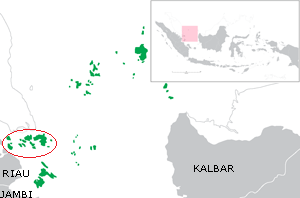
The Riau Archipelago is a geographic term for the core group of islands within the Riau Islands Province in Indonesia, and located south of Singapore. Before the province of Riau Islands was formed, there was no ambiguity in term; however, in Indonesian language, both the archipelago and administrative province are referred to as simply "Kepulauan Riau". The province may have the word "Provinsi" preceding it for clarity. Additionally the term BBK for Batam Bintan Karimun may refer to the archipelago.

Riau Islands Province in Indonesia

The Riau Islands is a province of Indonesia. It comprises a total of 1,796 islands lying between the Malacca Strait, the Karimata Strait and the South China Sea. The province is located on one of the world's busiest shipping lanes, sharing water borders with Singapore, Malaysia, and Vietnam. Originally part of the province of Riau, the Riau Islands became Indonesia's third-youngest province in September 2002. The capital is Tanjung Pinang and the largest city is Batam.

Indonesia Republic in Southeast Asia

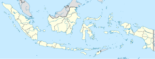
Indonesia, officially the Republic of Indonesia, is a country in Southeast Asia, between the Indian and Pacific oceans. It is the world's largest island country, with more than seventeen thousand islands, and at 1,904,569 square kilometres, the 14th largest by land area and the 7th largest in combined sea and land area. With over 261 million people, it is the world's 4th most populous country as well as the most populous Muslim-majority country. Java, the world's most populous island, contains more than half of the country's population.

Coordinates: 0°51′N103°52′E / 0.85°N 103.87°E / 0.85; 103.87

Geographic coordinate system Coordinate system

A geographic coordinate system is a coordinate system that enables every location on Earth to be specified by a set of numbers, letters or symbols. The coordinates are often chosen such that one of the numbers represents a vertical position and two or three of the numbers represent a horizontal position; alternatively, a geographic position may be expressed in a combined three-dimensional Cartesian vector. A common choice of coordinates is latitude, longitude and elevation. To specify a location on a plane requires a map projection.


Related Research Articles

Bintan Island Island of the Riau Archipelago in Riau Islands, Indonesia

Bintan Island or Negeri Segantang Lada is an island in the Riau archipelago of Indonesia. It is part of the Riau Islands province, the capital of which, Tanjung Pinang, lies in the island's south and is the island's main community.

Great Karimun

Great Karimun or just Karimun is one of the islands in the Riau Islands province of Indonesia, administratively part of Karimun Regency. It lies about 37 km southwest of Singapore, 54 km west of Batam, 24 km northeast of Rangsang Island and 32 km north of Kundur Island.

Indragiri Hilir Regency Regency in Riau, Indonesia

Indragiri Hilir is a regency (kabupaten) of Riau, Indonesia. It is located on the island of Sumatra. The regency has an area of 12,614.78 km² and population of 661,779 at the 2010 Census; the latest official estimate was 759,793.

Bulan Island or Bulang is an island located 2.5 km south-west of Batam Island, with a land area of 100 km2. It is located in the Sijori Growth Triangle, Riau Islands Province, Indonesia. It is the largest island adjacent to Batam on its western side and is administratively part of Batam city. The strait between them is shallow and land reclamation and island amalgamation is feasible.

Rempang is an island, located 2.5 km South-East of Batam, 165.83 km². belonging to a group of three islands called Barelang A member of the Riau Archipelago, in the Riau Islands province of Indonesia, Rempang is located just south of Batam and north of Galang which themselves are just south of Singapore and Johor. The nearest city to Rempang is Tanjung Pinang on Bintan, situated about half hour boat ride from Batam.

Niur is an island in Riau province close to the east coast of Sumatra island, Indonesia. It is situated just south of Baso (island). The area of the island is 342 km².

Raja Haji Fisabilillah International Airport, formerly Kijang Airport, is an international airport located in Tanjung Pinang, Bintan, Riau Islands, Indonesia. It is the second largest airport in Riau Islands, after the Hang Nadim International Airport in Batam.

Karimun Regency Regency in Riau Islands, Indonesia

The Karimun Regency is located in the Riau Islands Province, Indonesia. Besides the main island of Great Karimun, the regency also includes the island of Kundur and a number of smaller islands.

Penyengat Island island in Indonesia

Penyengat Island, Pulau Penyengat in Indonesian is an island in Riau Islands Province, Indonesia. It lies just off Bintan Island, close to Tanjung Pinang, the capital of Riau Islands Province. The island has historical significance, dating back to the 18th Century, when it was established as a fort as part of the Sultanate of Johor-Riau by the Bugis. The island contains the tomb of Raja Ali Haji, a 19th-century Islamic historian and scholar. It is a small island that is approximately 6 km from the town of Tanjung Pinang, Riau Islands province. This island measures approximately 2500 meters x 750 meters, and is approximately 35 km from the island of Batam. This island can be reached by using a boat or better known by pompong boat. By using pompong boat, it takes approximately 15 minutes drive.

Sambu Island island in Indonesia

Sambu is a minor island in Riau Islands Province of Indonesia. It is located on the north-western side of Batam island.

Simpang-kiri River river in Indonesia

Simpang-kiri River is a river in Riau province, central-eastern Sumatra, Indonesia, about 800 km northwest of the capital Jakarta.

Kampar Kanan River river in Indonesia

Kampar Kanan River is a river in Riau province, Sumatra island, Indonesia. It is a tributary of the Kampar River.

The Rukan Islands, also known as the Three Brothers, is a group of three small islands at the south entrance of Durian Strait, in the Riau Islands Province of Indonesia, off the north coast of Sumatra near Singapore. The group extends about 7.2 km north to south, and is surrounded by many dangerous wrecks.

Little Iyu Island is a small island in the Strait of Malacca, about 4.5 km north-west of Little Karimun Island, about 50 km west of Singapore, and about 800 m north-east of the Great Iyu Island. The two Iyu islets are known as The Brothers.

Great Iyu Island is a small uninhabited island in the Strait of Malacca, about 4.5 km north-west of Little Karimun, about 50 km west of Singapore, and about 800 m south-west of Little Iyu Island. The two Iyu islets are known as The Brothers. The island belongs to the Karimun Regency of the Riau Islands Province of Indonesia.

Little Karimun is an island in the Strait of Malacca, about 58 kilometres (36 mi) west of Batam and 35 km south-west of Singapore. It belongs to the Karimun Regency of the Riau Islands Province of Indonesia. It is located just off the east coast of Sumatra.

Sungai Guntung Town in Riau, Indonesia

Sungai Guntung, sometimes referred to as Sei Guntung and administratively the kelurahan of Tagaraja, is an Indonesian port town in Indragiri Hilir Regency, Riau with a population of over 14,000 in 2016.

Simpang-kanan River Disambiguation page providing links to topics that could be referred to by the same search term

Simpang-kanan River is the name of several Indonesian rivers: