
The South China Sea is a marginal sea of the Western Pacific Ocean. It is bounded in the north by South China, in the west by the Indochinese Peninsula, in the east by the islands of Taiwan and northwestern Philippines, and in the south by Borneo, eastern Sumatra and the Bangka Belitung Islands, encompassing an area of around 3,500,000 km2 (1,400,000 sq mi). It communicates with the East China Sea via the Taiwan Strait, the Philippine Sea via the Luzon Strait, the Sulu Sea via the straits around Palawan, and the Java Sea via the Karimata and Bangka Straits. The Gulf of Thailand and the Gulf of Tonkin are part of the South China Sea.

The Java Sea is an extensive shallow sea on the Sunda Shelf, between the Indonesian islands of Borneo to the north, Java to the south, Sumatra to the west, and Sulawesi to the east. Karimata Strait to its northwest links it to the South China Sea. It is a part of the western Pacific Ocean.

Anambas Islands Regency is a small archipelago of Indonesia, located 150 nautical miles northeast of Batam Island in the North Natuna Sea between the Malaysian mainland to the west and the island of Borneo to the east. Geographically part of the Tudjuh Archipelago, it is administratively a regency within the Riau Islands Province. It covers a land area of 590.14 square kilometres (227.85 sq mi) and had a population of 37,411 at the 2010 Census and 47,402 at the 2020 Census; the official estimate as at mid 2023 was 49,090. The administrative centre is at Tarempa on Siantan Island.

Sandys Parish ( "sands") is one of the nine parishes of Bermuda. It is named for English aristocrat Sir Edwin Sandys (1561–1629), and hence there is no apostrophe in the name.

Warwick Parish is one of the nine parishes of Bermuda. It is named after Robert Rich, 2nd Earl of Warwick (1587-1658).
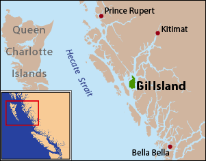
Gil Island is an island on the North Coast of British Columbia, Canada, located on the west side of Whale Channel in the entrance to Douglas Channel, one of the main coastal inlets, on the route of the Inside Passage between Pitt Island and Princess Royal Island. It is 26 km (16 mi) long, with a width ranging from 6 to 13 km, and an area of 231 km2. The only named summit on the mountainous island is Mount Gil, which faces the opening of Douglas Channel.

The Frioul archipelago is a group of four islands located off the Mediterranean coast of France, approximately 4 kilometres from Marseille. The islands of the archipelago cover a total land area of approximately 200 hectares. According to the 2015 census, the population was 146.

Pelalawan is a regency (kabupaten) of Riau Province, Indonesia. It is located on the island of Sumatra. The regency was created on 4 October 1999 as a result of the division of Kampar Regency, of which it was previously the eastern 43%. It now has an area of 13,408.72 km2 and had a population of 301,829 at the 2010 Census and 390,046 at the 2020 Census; the official estimate as at mid 2023 was 415,469. The administrative centre is in the town of Pangkalan Kerinci.

The Gwa'sala-Nakwaxda'xw Nations are an amalgamation of two Kwakwaka'wakw peoples in a band government based on northern Vancouver Island in British Columbia, whose main reserve community is near the town of Port Hardy in the Queen Charlotte Strait region of the Central Coast region of British Columbia, Canada. In the 1960s the Gwa'sala (Gwaʼsa̱la), the 'Nakwaxda'xw (ʼNakʼwaxdaʼx̱w) and the Kwakiutl peoples were amalgamated. Eventually the Gwa'sala-'Nakwaxda'xw Nations and the Kwakiutl First Nation separated into the two groups that are recognized by the federal government to this day. Gwa'sala-'Nakwaxda'xw Nations were forcibly relocated from their homelands to a location near Port Hardy.
The Lytton First Nation, a First Nations band government, has its headquarters at Lytton in the Fraser Canyon region of the Canadian province of British Columbia. While it is the largest of all Nlaka'pamux bands, unlike all other governments of the Nlaka'pamux (Thompson) people, it is not a member of any of the three Nlaka'pamux tribal councils, which are the Nicola Tribal Association, the Fraser Canyon Indian Administration and the Nlaka'pamux Nation Tribal Council.
The Tŝideldel First Nation is the band government of the Tsi Del Del subgroup of the Tsilhqot'in people, located in the Chilcotin District in the western Central Interior region of the Canadian province of British Columbia. It is a member of the Tsilhqot'in National Government.
The Tlʼetinqox-tʼin Government Office is a First Nations government located in the Chilcotin District in the western Central Interior region of the Canadian province of British Columbia. Governing a reserve communities near Alexis Creek known as Anaham Reserve First Nations or Anaham, it is a member of the Tsilhqotʼin Tribal Council aka known as the Tsilhqotʼin National Government. The main reserve is officially known as Anahim's Flat No. 1, and is more commonly as Anaham. Other reserves are Anahim's Meadow No. 2 and 2A, and Anahim Indian Reserves Nos. 3 through 18. Anaham, or Anahim and Alexis were chiefs of the Tsilhqotʼin during the Chilcotin War of 1864, although they and their people did not take part in the hostilities.

The Lil'wat First Nation, a.k.a. the Lil'wat Nation or the Mount Currie Indian Band, is a First Nation band government located in the southern Coast Mountains region of the Interior of the Canadian province of British Columbia. It is a member of the Lillooet Tribal Council, which is the largest grouping of band governments of the St'at'imc or Stl'atl'imx people. Other St'at'imc governments include the smaller In-SHUCK-ch Nation on the lower Lillooet River to the southwest, and the independent N'quatqua First Nation at the near end of Anderson Lake from Mount Currie, which is the main reserve of the Lil'wat First Nation, and also one of the largest Indian reserves by population in Canada.
Tarakan is an island and co-extensively the sole city within the Indonesian province of North Kalimantan. The island city is the largest urban area in North Kalimantan population-wise and is located in northern Borneo, midway along the coast of the province. The city boundaries are co-extensive with the island. Once a major oil-producing region during the colonial period, Tarakan had great strategic importance during the Pacific War and was among the first Japanese targets early in the conflict. It is the sole city within the newly established Indonesian province of North Kalimantan. According to Statistics Indonesia, the city had a population of 193,370 at the 2010 Census and 242,786 inhabitants at the 2020 Census; the official estimate as at mid 2023 was 249,960.
This is an article about the extreme points of Indonesia.
The Hartley Bay Indian Band is also known as the Gitga'at First Nation or the Hartley Bay First Nation. The members of the Gitga'at First nation are often referred to as Gitka'a'ata. The population of Gitk’a’ata peoples living in Hartley Bay ranges from approximately 130-200 people. There are also about 400-500 Gitk’a’ata peoples living in Prince Rupert, British Columbia, Canada, a neighboring territory. The Gitk’a’ata people have lived in Hartley Bay for hundreds of years, if not always. Some notable things regarding the Gitga'at First Nation are their economy, geography, government, sports involvement, COVID-19 regulations, and relations.
Huyền Sơn is a commune (xã) and village in Lục Nam District, Bắc Giang Province, in northeastern Vietnam.

Matak Airport is located on the island of Matak in the Anambas Islands on Riau Islands Province, Indonesia. It serves charter flights from and to Jakarta–Halim for MedcoEnergi, as well as commercial flights to and from Tanjung Pinang and Batam.

Kleptuza Glacier is a 6 km long and 6 km wide glacier draining the east slopes of Mount Hector in the Trojan Range and the north slopes of Osterrieth Range on Anvers Island in the Palmer Archipelago, Antarctica. Situated southeast of Thamyris Glacier and west of Altimir Glacier. Flowing northwards to enter Fournier Bay east of Madzharovo Point and west of Studena Point.
