
Coalgate is a city in and the county seat of Coal County, Oklahoma, United States. The population was 1,967 at the 2010 census, a 1.9 percent decrease from the figure of 2,005 recorded in 2000. The town was founded in 1889 in the Choctaw Nation, Indian Territory as a coal mining camp named Liddle. The name changed to Coalgate on January 23, 1890.
Red Deer is a city in central Alberta, Canada. It is located near the midpoint of the Calgary–Edmonton Corridor and is surrounded by Red Deer County. With a recorded population of 100,418 in the Canada 2016 census, Red Deer became the third Alberta city to surpass 100,000 people. The city is located in aspen parkland, a region of rolling hills that is home to oil, grain, and cattle production. It is a centre for oil and agriculture distribution, and the surrounding region is a major centre for petrochemical production.

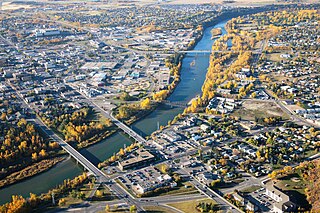
Lethbridge is a city in the province of Alberta, Canada. With a recorded population of 101,482 in its 2019 municipal census, Lethbridge became the fourth Alberta city to surpass 100,000 people. The nearby Canadian Rocky Mountains contribute to the city's warm summers, mild winters, and windy climate. Lethbridge lies southeast of Calgary on the Oldman River.

Drumheller is a town within the Red Deer River valley in the badlands of east-central Alberta, Canada. It is located 110 kilometres (68 mi) northeast of Calgary, and 97 kilometres (60 mi) south of Stettler. The Drumheller portion of the Red Deer River valley, often referred to as Dinosaur Valley, has an approximate width of 2 kilometres (1.2 mi) and an approximate length of 28 kilometres (17 mi).

Cardston is a town in Alberta, Canada. The land on which Cardston was founded was originally inhabited by the Niitsitapi (Blackfoot) people of Kainai but was not considered part of Blackfoot Territory by the Government of Canada in the Treaty 7 agreement of 1877.

Fort Macleod, originally named Macleod, is a town in the southwest of the province of Alberta, Canada. It was founded as a North-West Mounted Police barracks, and is named in honour of the North-West Mounted Police Colonel James Macleod. It was known as the Town of Macleod between 1892 and 1912.
Claresholm is a town located within southern Alberta, Canada. It is located on Highway 2, approximately 91 km (57 mi) northwest of the City of Lethbridge and 125 km (78 mi) south of the City of Calgary.

Stirling is a village in the County of Warner No. 5, Alberta, Canada. The village is located on Highway 4, approximately 31 km (19 mi) southeast of Lethbridge and 72 km (45 mi) northwest of the Canada–US border.
Granum is a hamlet in southern Alberta, Canada that is under the jurisdiction of the Municipal District of Willow Creek No. 26. It is located at the junction of Highway 2 and Highway 519 west of Lethbridge. Incorporated as the Village of Leavings in 1904, it changed its name to Granum in 1908 and held town status between late 1910 and early 2020.
Diamond City is a hamlet in southern Alberta, Canada within the Lethbridge County. It is located on Highway 25, approximately 13 kilometres (8.1 mi) north of Lethbridge. The community was so named on account of deposits of coal near the original town site, a resource also called "black diamond".

Champion is a village in southern Alberta, Canada within Vulcan County. It is located on Highway 23, approximately 74 kilometres (46 mi) north of Lethbridge and 147 kilometres (91 mi) south of Calgary.
Bellevue is an urban community in the Rocky Mountains within the Municipality of Crowsnest Pass in southwest Alberta, Canada. It was formerly incorporated as a village prior to 1979 when it amalgamated with four other municipalities to form Crowsnest Pass.
Burdett is a hamlet in Alberta, Canada within the County of Forty Mile No. 8. It is located approximately 71 km (44 mi) west of Medicine Hat and 97 km (60 mi) east of Lethbridge on Highway 3. Also, Burdett is regarded as the site of Canada's first irrigation pivot.

Evansburg is a hamlet in west-central Alberta, Canada, within Yellowhead County. It is located on Highway 16A, approximately 88 kilometres (55 mi) west of Edmonton and 96 kilometres (60 mi) east of Edson. The hamlet is adjacent to the Pembina River and the Pembina River Provincial Park.

Beverly is a former urban municipality within the Edmonton Capital Region of Alberta, Canada. Beverly incorporated as a village on March 22, 1913 and became the Town of Beverly on July 13, 1914. It later amalgamated with the City of Edmonton on December 30, 1961. The population of Beverly was 8,969 at the time of amalgamation.
Cardiff is a hamlet in central Alberta, Canada within Sturgeon County. It is located 3 kilometres (1.9 mi) east of Highway 2, approximately 15 kilometres (9.3 mi) north of Edmonton's city limits. The Town of Morinville is 1.6 kilometres (0.99 mi) to the west of Cardiff.
Iron Springs is a hamlet in southern Alberta, Canada within the Lethbridge County. It is located on Highway 25, approximately 28 kilometres (17 mi) northeast of Lethbridge. It was founded in 1925 when the railroad arrived. The community was named after a spring of the same name near the original town site.
Monarch is a hamlet in southern Alberta, Canada within the Lethbridge County. It is located on Highway 3A, approximately 23 kilometres (14 mi) northwest of Lethbridge. It was formerly a village, existing as such from about 1913 to about 1939.

In the 2011 Census, the City of Calgary had a population of 1,096,833 residents, representing 30% of the 3,645,257 residents in all of Alberta, and 3% compared to a population of 33,476,688 in all of Canada. The total population of the Calgary census metropolitan area (CMA) was 1,214,839. Calgary is the largest city in Alberta, and the third-largest municipality and fourth-largest metropolitan area in Canada, as of 2016.
