
The San Juan Mountains are a high and rugged mountain range in the Rocky Mountains in southwestern Colorado and northwestern New Mexico. The area is highly mineralized and figured in the gold and silver mining industry of early Colorado. Major towns, all old mining camps, include Creede, Lake City, Silverton, Ouray, and Telluride. Large scale mining has ended in the region, although independent prospectors still work claims throughout the range. The last large scale mines were the Sunnyside Mine near Silverton, which operated until late in the 20th century and the Idarado Mine on Red Mountain Pass that closed down in the 1970s. Famous old San Juan mines include the Camp Bird and Smuggler Union mines, both located between Telluride and Ouray.

Ouray County is one of the 64 counties of the U.S. state of Colorado. As of the 2010 census, the population was 4,436. The county seat is Ouray. Because of its rugged mountain topography, Ouray County is also known as the Switzerland of America.

Loghill Village is an affluent mountain resort community on Log Hill Mesa in Ouray County, Colorado, United States. The populace of the communities in the Loghill area have been placed under the Loghill Village census-designated place (CDP). The population was 311 at the 2000 census and 521 as of the 2010 United States Census.

Ouray is a Home Rule Municipality that is the county seat and the most populous city of Ouray County, Colorado, United States. The city population was 1,000 as of the 2010 census. The Ouray Post Office has the ZIP code 81427. Ouray's climate, natural alpine environment, and scenery has earned it the nickname, "Switzerland of America".

Ridgway, coined Gateway to the San Juans, is a Home Rule Municipality in Ouray County, in the southwestern portion of the U.S. State of Colorado. The town is a former railroad stop on the Uncompaghre River in the northern San Juan Mountains. The town population was 713 at the 2000 census and 924 according to the 2010 census.

Ouray ) was a Native American chief of the Tabeguache (Uncompahgre) band of the Ute tribe, then located in western Colorado. Because of his leadership ability, Ouray was acknowledged by the United States government as a chief of the Ute and he traveled to Washington, D.C. to negotiate for the welfare of the Utes. Raised in the culturally diverse town of Taos, Ouray learned to speak many languages that helped him in the negotiations, which were complicated by the manipulation of his grief over his five-year-old son lost during an attack by the Sioux. Ouray met with Presidents Lincoln, Grant, and Hayes and was called the man of peace because he sought to make treaties with settlers and the government.

The Western Slope refers to a region of the state of Colorado incorporating everything in the state west of the Continental Divide. Bodies of water west of the Divide flow toward the Pacific Ocean. Water that falls and flows east of the Divide heads east. The Western Slope encompasses about 33% of the state, but has just 10% of the state's residents. The eastern part of the state, including the San Luis Valley and the Front Range is the more populous portion of the state.
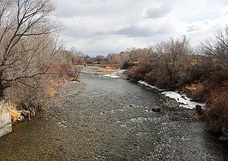
The Uncompahgre River is a tributary of the Gunnison River, approximately 75 mi (121 km) long, in southwestern Colorado in the United States. Lake Como at 12,215 ft (3723m) in northern San Juan County, in the Uncompahgre National Forest in the northwestern San Juan Mountains is the headwaters of the river. It flows northwest past Ouray, Ridgway, Montrose, and Olathe and joins the Gunnison at Confluence Park in Delta.
Uncompahgre Peak is the sixth highest summit of the Rocky Mountains of North America and the U.S. state of Colorado. The prominent 14,321-foot (4365.0 m) fourteener is the highest summit of the San Juan Mountains and the highest point in the drainage basin of the Colorado River and the Gulf of California. It is located in the Uncompahgre Wilderness in the northern San Juans, in northern Hinsdale County approximately 7 miles (11 km) west of the town of Lake City.

The Grand Valley is an extended populated valley, approximately 30 miles (48 km) long and 5 miles (8.0 km) wide, located along the Colorado River in Mesa County in western Colorado and Grand County in eastern Utah in the Western United States. The valley contains the city of Grand Junction, as well as other smaller communities such as Fruita and Palisade. The valley is a major fruit-growing region that contains many orchards and vineyards, and is home to one of two designated American Viticultural Areas in Colorado: the Grand Valley AVA. It takes its name from the "Grand River", the historical name of the Colorado River upstream from its confluence with the Green River that was used by locals in the late 19th and early 20th century. The valley is the most densely populated area on the Colorado Western Slope, with Grand Junction serving as an unofficial capital of the region, as a counterpoint to Denver on the eastern slope of the Rocky Mountains in the Colorado Front Range. Interstate 70 and U.S. Highway 6 run through the valley from west-to-east. The Grand Valley is part of the larger Colorado Plateau desert lands.

The Uncompahgre Plateau in western Colorado is a distinctive large uplift part of the Colorado Plateau. Uncompahgre is a Ute Indian word that describes the water: "Dirty Water" or "Rocks that make Water Red".

Red Mountain Pass elevation 11,018 ft (3,358 m) is a mountain pass in the San Juan Mountains of western Colorado in the United States.
The San Juan Skyway is an All-American Road and a component in the Colorado Scenic and Historic Byway System. It forms a 233.0-mile (375.0 km) loop in the southwest part of the U.S. state of Colorado traversing the heart of the San Juan Mountains. It roughly parallels the routes of the narrow gauge railways: Rio Grande Southern ; and the unconnected Ouray and Silverton Branches of the Denver & Rio Grande along US 550 with the Silverton Railroad bridging a part of the gap. Its origin can be traced to the Around the Circle Route promoted by the D&RG.

Dallas Divide is a high mountain pass in the United States state of Colorado located on State Highway 62 about 12 miles (19 km) west of the town of Ridgway.
Dallas was a town in Ouray County, Colorado, United States. It lay about 3 miles (5 km) north of the present town of Ridgway at the confluence of Dallas Creek and the Uncompahgre River. A community named in tribute to the historic town bearing the name Dallas Meadows now exists at its historic location.

The Rio Grande Southern Railroad was a 3 ft Narrow-gauge Railroad which ran in the southwestern region of the US state of Colorado, from the towns of Durango to Ridgway, routed via Lizard Head Pass. Built by Russian Immigrant and Colorado Toll Road builder Otto Mears, the RGS operated from 1891 through 1951 and was built with the intent to transport immense amounts of silver mineral traffic that were being produced by the mining communities of Rico and Telluride. On both ends of the railroad, there were interchanges with The Denver and Rio Grande Railroad, which would ship the traffic the RGS hauled elsewhere like the San Juan Smelter in Durango.

South Bay is a region in southwestern San Diego County, California consisting of the cities and unincorporated communities of Bonita, Chula Vista, Imperial Beach, Lincoln Acres, National City, and South San Diego.

Eldredge is an unincorporated community in Ouray County, Colorado, United States. The community is located between Colona and Ridgway - both within Ouray County - north of Ridgway State Park on the Colorado stretch of U.S. Route 550 and the Uncompahgre River.

Log Hill Mesa is a mesa in Ouray County, Colorado, United States. Log Hill Mesa comprises part of the southern end of the Uncompahgre Plateau and faces south towards the Sneffels Range.

