Loghill Village, Colorado

Last updated
Loghill Village, Colorado
LoghillVillage.jpg
Log Hill Mesa on which sits Loghill Village.
Ouray County Colorado Incorporated and Unincorporated areas Loghill Village Highlighted.svg
Location of the Loghill_Village CDP in Ouray County, Colorado.
Usa edcp location map.svg
Red pog.svg
Loghill Village
Location of the Loghill Village CDP in the United States.
Coordinates: 38°11′57″N107°46′31″W / 38.1992253°N 107.7753338°W / 38.1992253; -107.7753338 (Loghill Village CDP, Colorado) Coordinates: 38°11′57″N107°46′31″W / 38.1992253°N 107.7753338°W / 38.1992253; -107.7753338 (Loghill Village CDP, Colorado) [1]
Country Flag of the United States.svg  United States
State Flag of Colorado.svg  Colorado
County Ouray County
Government
[2]
  Type unincorporated community
Area
[1]
  Total6.129 sq mi (15.874 km2)
  Land6.129 sq mi (15.874 km2)
  Water0.000 sq mi (0.000 km2)
Elevation
[2]
7,874 ft (2,400 m)
Population
 (2020) [3]
  Total617
  Density100/sq mi (39/km2)
Time zone UTC-7 (MST)
  Summer (DST) UTC-6 (MDT)
ZIP Code [4]
81432
Area code 970
GNIS feature [2] Loghill Village CDP

Loghill Village is a Census-designated place (CDP) in and governed by Ouray County, Colorado, United States. The CDP is a part of the Montrose, CO Micropolitan Statistical Area. The population of the Loghill Village CDP was 617 at the United States Census 2020. [3] The Ridgway post office (Zip Code 81432) serves Loghill Village postal addresses. [4]

Contents

Geography

Loghill Village is located on Log Hill Mesa north of the town of Ridgway and northeast of Pleasant Valley. Loghill Village borders Ridgway State Park and Eldredge, though there is no direct road access between the two. Via road, Loghill Village is nearest to the town of Ridgway which can be seen from its position on the mesa.

Loghill is primarily covered in large Ponderosa Pine trees, piñons and junipers. Wildlife is abundant on the Mesa with a fairly large population of Mule Deer, Elk, Bobcats, Lynxes, Black Bears (of various colors), wild turkeys and an occasional sighting of mountain lions. Almost 1,000 feet higher than Ridgway, the types and sizes of flora vary greatly. For example, Aspen trees are seen here and there on the mesa, as opposed to the lower Ridgway valley where they are scarce. Aspens can be seen more abundantly in the foothills and mid mountain areas of the San Juan Mountains and Cimarrons.

The Loghill Village CDP has an area of 3,923 acres (15.874 km2), all land. [1]

Demographics

Loghill Village CDP, Colorado
YearPop.±%
2000 311    
2010 521+67.5%
2020 617+18.4%
Source: United States Census Bureau

The United States Census Bureau initially defined the Loghill Village CDP for the United States Census 2000.


Communities

Loghill Village is divided into two main communities by a shallow gorge, a common greenbelt, running southwest to northeast. [5]

Tourism

Loghill Village is primarily a residential community. There is some tourism at the golf course, the former Fairway Pines Golf Course which is now known as the Divide Ranch and Club Golf Course. There is a bar and grill restaurant, open seasonally, at the Divide golf course club house. The Loghill Village Park and Recreation Department maintains a matrix of trails on the mesa with a combined length of more than six miles. The Escarpment trail has several lookout points overlooking the town of Ridgway and Pleasant Valley with views of the Sneffels Range and Cimmaron Range. No wheeled traffic is allowed on the hiking trails.

Infrastructure

Transportation

The nearest airport with scheduled service is Montrose Regional Airport, located approximately 25 miles (40 km) to the north via road, 19 miles (31 km) northwest. [7] Loghill Village can be reached by exiting west off of U.S. Route 550 and north off State Highway 62. The latter road is also part of the San Juan Skyway Scenic Byway. [8]

See also

Related Research Articles

<span class="mw-page-title-main">San Miguel County, Colorado</span> County in Colorado, United States

San Miguel County is a county located in the U.S. state of Colorado. As of the 2020 census, the population was 8,072. The county seat is Telluride. The county is named for the San Miguel River.

<span class="mw-page-title-main">Ouray County, Colorado</span> County in Colorado, United States

Ouray County is a county located in the U.S. state of Colorado. As of the 2020 census, the population was 4,874. The county seat is Ouray. Because of its rugged mountain topography, Ouray County is also known as the Switzerland of America.

<span class="mw-page-title-main">Roxborough Park, Colorado</span> Census Designated Place in Colorado, United States

Roxborough Park is an unincorporated community and a census-designated place (CDP) located in and governed by Douglas County, Colorado, United States. The CDP is a part of the Denver–Aurora–Lakewood, CO Metropolitan Statistical Area. The population of the Roxborough Park CDP was 9,099 at the United States Census 2010. The Roxborough Village Metropolitan District and the Roxborough Water and Sanitation District provide services. The Littleton post office serves the area.

<span class="mw-page-title-main">Battlement Mesa, Colorado</span> Ceneus-designated place in Garfield County, Colorado, United States

Battlement Mesa is a census-designated place (CDP) and post office in and governed by Garfield County, Colorado, United States. The CDP is a part of the Glenwood Springs, CO Micropolitan Statistical Area. The Battlement Mesa post office has the ZIP Codes 81635 and 81636. At the United States Census 2020, the population of the Battlement Mesa CDP was 5,438. The Battlement Mesa Metropolitan District provides services.

<span class="mw-page-title-main">Red Feather Lakes, Colorado</span> Census Designated Place in Colorado, United States

Red Feather Lakes is an unincorporated town, a post office, and a census-designated place (CDP) located in and governed by Larimer County, Colorado, United States. The CDP is a part of the Fort Collins, CO Metropolitan Statistical Area. The Red Feather Lakes post office has the ZIP Code 80545. At the United States Census 2010, the population of the Red Feather Lakes CDP was 343, while the population of the 80545 ZIP Code Tabulation Area was 851 including adjacent areas.

<span class="mw-page-title-main">Montrose, Colorado</span> City in Colorado, United States

Montrose is a home rule municipality that is the county seat and the most populous municipality of Montrose County, Colorado, United States. The city population was 20,291 at the 2020 census, within a total area of 18.5 square miles. The main road that leads in and out of Montrose is U.S. Highway 50. The town is located in western Colorado, in the Uncompahgre Valley, and is an economic, labor, and transportation waypoint for the surrounding recreation industry.

<span class="mw-page-title-main">Ouray, Colorado</span> City in Colorado, United States

Ouray is a home rule municipality that is the county seat of Ouray County, Colorado, United States. The city population was 1,000 as of the 2010 census. The Ouray Post Office has the ZIP Code 81427. Located at an elevation of 7,792 feet (2,375 m), Ouray's climate, natural alpine environment, and scenery have earned it the nickname "Switzerland of America".

<span class="mw-page-title-main">Ridgway, Colorado</span> Town in Colorado, United States

The Town of Ridgway is the home rule municipality that is the most populous municipality in Ouray County, Colorado, United States. The town is a former railroad stop on the Uncompahgre River in the northern San Juan Mountains. The town population was 713 at the 2000 census and 924 according to the 2010 census.

<span class="mw-page-title-main">Keystone, Colorado</span> Census Designated Place in Colorado, United States

Keystone is an unincorporated community and a census-designated place (CDP) located in and governed by Summit County, Colorado, United States. The CDP is a part of the Breckenridge, CO Micropolitan Statistical Area. The population of the Keystone CDP was 1,369 at the United States Census 2020. The Dillon post office (Zip Code 80435) serves Keystone postal addresses. The Keystone CDP includes the Keystone Resort and Keystone village.

<span class="mw-page-title-main">U.S. Route 550</span> Highway in the United States

U.S. Route 550 (US 550) is a spur of U.S. Highway 50 that runs from Bernalillo, New Mexico to Montrose, Colorado in the western United States. The section from Silverton to Ouray is frequently called the Million Dollar Highway. It is one of the roads on the Trails of the Ancients Byway, one of the designated New Mexico Scenic Byways.

<span class="mw-page-title-main">Uncompahgre National Forest</span> National Forest in western Colorado, United States

Uncompahgre National Forest is a U.S. National Forest covering 955,229 acres in parts of Montrose, Mesa, San Miguel, Ouray, Gunnison, Hinsdale, San Juan, and Delta Counties in western Colorado. Its headquarters are in Delta County, in the city of Delta. It borders the San Juan National Forest to the south.

The San Juan Skyway Scenic and Historic Byway is a 236-mile (380 km) All-American Road, National Forest Scenic Byway, and Colorado Scenic and Historic Byway located in Dolores, La Plata, Montezuma, San Juan, and San Miguel counties, Colorado, USA. The byway forms a loop in southwestern Colorado traversing the heart of the San Juan Mountains. The San Juan Skyway reaches its zenith at Red Mountain Pass at elevation 11,018 feet (3,358 m). Mesa Verde National Park was one of the original UNESCO World Heritage Sites. The Silverton Historic District and the Telluride Historic District are National Historic Landmarks.

<span class="mw-page-title-main">Redvale, Colorado</span> Census-designated place in Colorado, United States

Redvale is an unincorporated town, a post office, and a census-designated place (CDP) located in and governed by Montrose County, Colorado, United States. The CDP is a part of the Montrose, CO Micropolitan Statistical Area. The Redvale post office has the ZIP Code 81431. At the 2020 census, the population of the Redvale CDP was 172, down from 236 in 2010.

<span class="mw-page-title-main">Castle Pines Village, Colorado</span> Census Designated Place in Colorado, United States

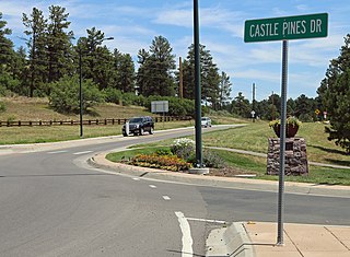
Castle Pines Village, also known as The Village at Castle Pines or The Village, is an unincorporated community and a census-designated place (CDP) located in and governed by Douglas County, Colorado, United States. The CDP is a part of the Denver–Aurora–Lakewood, CO Metropolitan Statistical Area. The population of the Castle Pines Village CDP was 3,614 at the United States Census 2010. Douglas County governs the unincorporated community and the Castle Pines Metropolitan District provides services. The Castle Rock post office serves the area.

<span class="mw-page-title-main">Trail of the Ancients</span> National Scenic Byways in Arizona, Colorado, New Mexico, and Utah, United States

The Trail of the Ancients is a collection of National Scenic Byways located in the U.S. Four Corners states of Utah, Colorado, New Mexico, and Arizona. These byways comprise:

A List of Communities in Ouray County.

<span class="mw-page-title-main">Colona, Colorado</span> Census-designated place in Colorado, United States

Colona is a census-designated place (CDP) located in and governed by Ouray County, Colorado, United States. The CDP is a part of the Montrose, CO Micropolitan Statistical Area. The population of the Colona CDP was 30 at the United States Census 2010. The Montrose post office (Zip Code 81401) serves the area.

<span class="mw-page-title-main">Portland, Colorado</span> Census-designated place in Ouray County, Colorado, United States

Portland is a census-designated place (CDP) located in and governed by Ouray County, Colorado, United States. The CDP is a part of the Montrose, CO Micropolitan Statistical Area. The population of the Portland CDP was 136 at the United States Census 2020. The Ridgway post office (Zip Code 81432) serves the area.

<span class="mw-page-title-main">Sterling Ranch, Colorado</span> Census Designated Place in Colorado, United States

Sterling Ranch is an unincorporated community and a census-designated place (CDP) located in and governed by Douglas County, Colorado, United States. The population was 1,789 at the 2020 census. The CDP is a part of the Denver–Aurora–Lakewood, CO Metropolitan Statistical Area. Douglas County governs the unincorporated community and the Sterling Ranch Community Authority Board provides services through several metropolitan districts. The Littleton post office serves the area.

Pine Valley is an unincorporated community and a census-designated place (CDP) located in and governed by Clear Creek County, Colorado, United States. The population was 363 at the 2020 census. The CDP is a part of the Denver–Aurora–Lakewood, CO Metropolitan Statistical Area. The Evergreen post office serves the area.

References

  1. 1 2 3 "State of Colorado Census Designated Places - BAS20 - Data as of January 1, 2020". United States Census Bureau . Retrieved December 26, 2020.
  2. 1 2 3 "U.S. Board on Geographic Names: Domestic Names". United States Geological Survey . Retrieved December 26, 2020.
  3. 1 2 United States Census Bureau. "Loghill Village CDP, Colorado" . Retrieved April 13, 2023.
  4. 1 2 "Look Up a ZIP Code". United States Postal Service . Retrieved December 26, 2020.
  5. "Loghill Village CDP Limits Map". Google. Retrieved April 18, 2011.
  6. 1 2 "Loghill Village CDP Limits Map". Google. Retrieved April 18, 2011.
  7. "Maps, Weather, Videos, and Airports for Loghill Village, United States" . Retrieved April 22, 2011.
  8. "San Juan Skyway". American's Byways. Archived from the original on 2011-01-07. Retrieved 2011-02-06.