
Sneffels was a town in Ouray County, Colorado, United States named after Mount Sneffels. [1] [2]
Sneffels was a town in Ouray County, Colorado, United States named after Mount Sneffels. [1] [2]
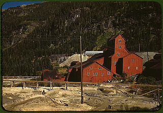
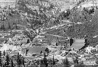
Sneffels was founded in 1875 and named after the mountain it was built on. [1] The town peaked at 2000 people and grew largely between the mid-1880s until 1891. [1] The Revenue Mill at Sneffels processed ore from the Virginius and other mines nearby. The mill complex employed around 600 men at its peak. [3]
Today there are scattered remnants and a few nearby residents. [1]
San Juan County is a county located in the U.S. state of Colorado. As of the 2020 census, the population was 705, making it the least populous county in Colorado. The county seat and the only incorporated municipality in the county is Silverton. The county name is the Spanish language name for "Saint John", the name Spanish explorers gave to a river and the mountain range in the area. With a mean elevation of 11,240 feet (3426 meters), San Juan County is the highest county in the United States.

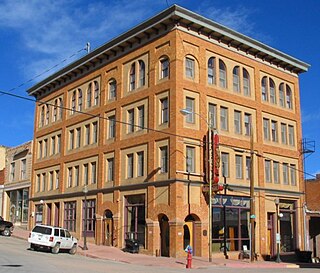
Ouray County is a county located in the U.S. state of Colorado. As of the 2020 census, the population was 4,874. The county seat is Ouray. Because of its rugged mountain topography, Ouray County is also known as the Switzerland of America.

The Town of Marble is a Statutory Town in Gunnison County, Colorado, United States. The town population was 133 at the 2020 United States Census.

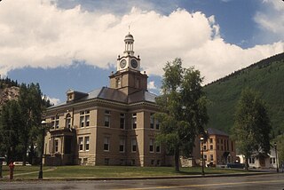
Ouray is a home rule municipality that is the county seat of Ouray County, Colorado, United States. The city population was 1,000 as of the 2010 census. The Ouray Post Office has the ZIP Code 81427. Ouray's climate, natural alpine environment, and scenery have earned it the nickname "Switzerland of America".
The City of Victor is a Statutory City in Teller County, Colorado, United States. Gold was discovered in Victor in the late 19th century, an omen of the future of the town. With Cripple Creek, the mining district became the second largest gold mining district in the country and realized approximately $10 billion of mined gold in 2010 dollars. It reached its peak around the turn of the century when there were about 18,000 residents in the town. Depleted ore in mines, labor strife and the exodus of miners during World War I caused a steep decline in the city's economy, from which it has never recovered. The population was 397 at the 2010 census. There is a resumed mining effort on Battle Mountain.

Yankee Boy Basin is an alpine basin in Ouray County, southwestern Colorado. It is in the San Juan Mountains, protected within Uncompahgre National Forest.

The Mount Sneffels Wilderness is a wilderness area in southwest Colorado managed by the Uncompahgre National Forest. It is about 5 miles (8.0 km) west of the town of Ouray. The area is named for Mt. Sneffels, which at 14,150 feet (4,310 m) is a prominent fourteener in the San Juan Mountains. The word "Sneffels" is likely an Americanization of the Old Norse word for Snæfell "snow mountain," which is also the namesake of the Snæfellsnes peninsula and Snæfellsjökull volcano in Iceland.
Mount Sneffels is the highest summit of the Sneffels Range in the Rocky Mountains of North America. The prominent 14,158-foot (4315.4 m) fourteener is located in the Mount Sneffels Wilderness of Uncompahgre National Forest, 6.7 miles (10.8 km) west by south of the City of Ouray in Ouray County, Colorado, United States. The summit of Mount Sneffels is the highest point in Ouray County.
The San Juan Skyway Scenic and Historic Byway is a 236-mile (380 km) All-American Road, National Forest Scenic Byway, and Colorado Scenic and Historic Byway located in Dolores, La Plata, Montezuma, San Juan, and San Miguel counties, Colorado, USA. The byway forms a loop in southwestern Colorado traversing the heart of the San Juan Mountains. The San Juan Skyway reaches its zenith at Red Mountain Pass at elevation 11,018 feet (3,358 m). Mesa Verde National Park was one of the origonal UNESCO World Heritage Sites. The Silverton Historic District and the Telluride Historic District are National Historic Landmarks.
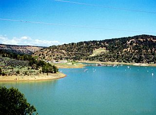
Ridgway Reservoir is a lake impounded by Ridgway Dam on the Uncompahgre River north of the town of Ridgway in Ouray County, Colorado in the western United States. Ridgway Dam was built as part of the Dallas Creek Project. Construction began in 1978 and completed in 1987. The lake was first filled in 1990 as an aid to irrigation of the Uncompahgre Valley and flood control. Today recreation opportunities are provided at Ridgway State Park along the lake.
Pittsburg is a former mining town from the late 19th century located about 9 miles north of Crested Butte, Colorado. While Pittsburg is sometimes considered a ghost town, none of the original structures still exist. The only cabins that still exist in the area were built after 1973 and are strictly summer vacation homes, as the area is inaccessible by cars during the winter.

The Idarado Mine was a mining operation in the San Juan Mountains of Ouray County, Colorado near the now-ghost town of Guston, producing primarily lead, silver and zinc along with lesser amounts of gold and copper. The mine is within the Sneffels-Red Mountain-Telluride mining district. The remains of the operation are visible from the Million Dollar Highway, north of Red Mountain Pass, between Ouray and Silverton, Colorado. The tunnels of the Idarado extend some 5 miles (8 km) west under 13,000 foot mountains to the Pandora Mill near Telluride, a trip of more than 60 miles (100 km) by highway.

Animas Forks is a ghost town located twelve miles (19 km) northeast of Silverton in San Juan County, Colorado, United States. The area is managed by the Bureau of Land Management. At over 11,000 feet, Animas Forks is one of the highest mining camps in the Western US.
Picacho is an unincorporated community in Imperial County, California. It is located on the Colorado River 29 miles (47 km) south-southeast of Palo Verde, at an elevation of 203 feet.
The Camp Bird Mine is a famous and highly productive old gold mine located between Ouray and Telluride, Colorado. The mine is within the Sneffels-Red Mountain-Telluride mining district in the San Juan Mountains.

The Alpine Loop Back Country Byway is a rugged 63-mile (101 km) Back Country Byway and Colorado Scenic and Historic Byway located in the high San Juan Mountains of Hindale, Ouray, and San Juan counties, Colorado, USA. The byway connects the mountain towns of Lake City, Ouray, and Silverton. The route ranges in elevation from 7,792 feet (2,375 m) in Ouray to 12,800 feet (3,901 m) at Engineer Pass. The byway features high mountain passes, alpine tundra, beautiful mountain meadows, ghost towns, and relics of the silver mining era. While the meadows and tundra are accessible to ordinary passenger vehicles, a high-clearance 4-wheel drive vehicle is required to travel the entire route.

Mayday is a ghost town in La Plata County, Colorado, United States. It was named for the Mayday Mine.

Log Hill Mesa is a mesa in Ouray County, Colorado. Log Hill Mesa includes part of the southern end of the Uncompahgre Plateau and faces south towards the Sneffels Range.
Pandora is an unincorporated community located 1.5 miles (2.4 km) east of Telluride in San Miguel County, Colorado.
El Dorado City, which is now a ghost town, was a mining camp in the Colorado Mining District at the mouth of January Wash at its confluence with El Dorado Canyon. It was located about a mile down the canyon from Huse Spring, at an elevation of 2382 feet. Its site was located nearby to the south southeast of the Techatticup Mine the primary source of the ore its mill processed.
Municipalities and communities of Ouray County, Colorado, United States | ||
|---|---|---|
| City |  | |
| Town | ||
| CDPs | ||
| Unincorporated communities | ||
| Ghost towns | ||
Coordinates: 37°58′31″N107°44′59″W / 37.97527°N 107.74978°W