
Brief Overview

The Denver and Rio Grande Western Railroad, often shortened to Rio Grande, D&RG or D&RGW, formerly the Denver & Rio Grande Railroad, was an American Class I railroad company. The railroad started as a 3 ft narrow-gauge line running south from Denver, Colorado, in 1870. It served mainly as a transcontinental bridge line between Denver and Ogden, Utah. The Rio Grande was also a major origin of coal and mineral traffic.
San Juan County is a county located in the U.S. state of Colorado. As of the 2020 census, the population was 705, making it the least populous county in Colorado. The county seat and the only incorporated municipality in the county is Silverton. The county name is the Spanish language name for "Saint John", the name Spanish explorers gave to a river and the mountain range in the area. With a mean elevation of 11,240 feet, San Juan County is the highest county in the United States and also has the two highest elevation houses in the United States; the ‘Bonnie Belle’ above Animas Forks at 11,900’ – 11,950’ elevation and an unnamed house above Picayune Gulch at 12,000’ elevation.

Ouray County is a county located in the U.S. state of Colorado. As of the 2020 Census, the population was 4,874. The county seat is Ouray. Because of its rugged mountain topography, Ouray County is also known as the "Switzerland of America".

Durango is a Home Rule City that is the county seat and the most populous municipality of La Plata County, Colorado, United States. The city population was 19,071 at the 2020 United States Census. Durango is the home of Fort Lewis College.

Ouray is a home rule municipality that is the county seat of Ouray County, Colorado, United States. The city population was 898 as of the 2020 census. The Ouray Post Office has the ZIP Code 81427. Located at an elevation of 7,792 feet (2,375 m), Ouray's climate, natural alpine environment, and scenery have earned it the nickname "Switzerland of America".

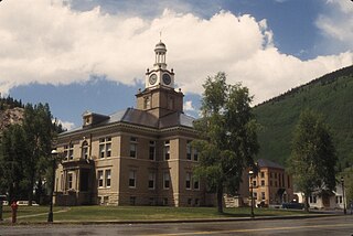
Silverton is a statutory town that is the county seat, the most populous community, and the only incorporated municipality in San Juan County, Colorado, United States. The town is located in a remote part of the western San Juan Mountains, a range of the Rocky Mountains. The first mining claims were made in mountains above the Silverton in 1860, near the end of the Colorado Gold Rush and when the land was still controlled by the Utes. Silverton was established shortly after the Utes ceded the region in the 1873 Brunot Agreement, and the town boomed from silver mining until the Panic of 1893 led to a collapse of the silver market, and boomed again from gold mining until the recession caused by the Panic of 1907. The entire town is included as a federally designated National Historic Landmark District, the Silverton Historic District.

U.S. Route 550 (US 550) is a spur of U.S. Highway 50 that runs from Bernalillo, New Mexico to Montrose, Colorado in the western United States. The section from Silverton to Ouray is frequently called the Million Dollar Highway. It is one of the roads on the Trails of the Ancients Byway, one of the designated New Mexico Scenic Byways.

Gilman is an abandoned mining town in southeastern Eagle County, Colorado, United States. The Gilman post office operated from November 3, 1886, until April 22, 1986. The U.S. Post Office at Minturn now serves Gilman postal addresses.

Red Mountain Pass elevation 11,018 ft (3,358 m) is a mountain pass in the San Juan Mountains of western Colorado in the United States.

Red Mountain is a set of three peaks in the San Juan Mountains of western Colorado in the United States, about five miles (8.0 km) south of Ouray. The mountains get their name from the reddish iron ore rocks that cover the surface. Several other peaks in the San Juan Mountains likewise have prominent reddish coloration from iron ore and are also called "Red Mountain".

The San Juan Skyway Scenic and Historic Byway is a 236-mile (380 km) All-American Road, National Forest Scenic Byway, and Colorado Scenic and Historic Byway located in Dolores, La Plata, Montezuma, San Juan, and San Miguel counties, Colorado, United States. The byway forms a loop in southwestern Colorado traversing the heart of the San Juan Mountains. The San Juan Skyway reaches its zenith at Red Mountain Pass at elevation 11,018 feet (3,358 m). Mesa Verde National Park was one of the original UNESCO World Heritage Sites. The Silverton Historic District and the Telluride Historic District are National Historic Landmarks.

The Rio Grande Southern Railroad was a 3 ft (914 mm) narrow-gauge railroad which ran in the southwestern region of the US state of Colorado, from the towns of Durango to Ridgway, routed via Lizard Head Pass. Built by German immigrant and Colorado toll road builder Otto Mears, the RGS operated from 1891 through 1951 and was built with the intent to transport immense amounts of silver mineral traffic that were being produced by the mining communities of Rico and Telluride. On both ends of the railroad, there were interchanges with The Denver and Rio Grande Railroad, which would ship the traffic the RGS hauled elsewhere like the San Juan Smelter in Durango.

The Idarado Mine was a mining operation in the San Juan Mountains of Ouray County, Colorado near the now-ghost town of Guston, producing primarily lead, zinc and silver along with small amounts of gold and copper. The mine is within the Sneffels-Red Mountain-Telluride mining district. The remains of the operation are visible from the Million Dollar Highway, north of Red Mountain Pass, between Ouray and Silverton, Colorado. The tunnels of the Idarado extend some 5 miles (8 km) west under 13,000 foot mountains to the Pandora Mill near Telluride, a trip of more than 60 miles (100 km) by highway.

The Silverton Railroad, now defunct, was an American 3 ft narrow gauge railroad constructed between Silverton, Colorado and mining districts near Red Mountain Pass, Colorado.

Animas Forks is an extinct mining town located 12 miles (19 km) northeast of Silverton in San Juan County, Colorado, United States. The area is managed by the Bureau of Land Management. At an elevation of 11,185 feet (3,409 m), Animas Forks is one of the highest mining camps in North America.

The Alpine Loop Back Country Byway is a rugged 63-mile (101 km) Back Country Byway and Colorado Scenic and Historic Byway located in the high San Juan Mountains of Hindale, Ouray, and San Juan counties, Colorado, USA. The byway connects the mountain towns of Lake City, Ouray, and Silverton. The route ranges in elevation from 7,792 feet (2,375 m) in Ouray to 12,800 feet (3,901 m) at Engineer Pass. The byway features high mountain passes, alpine tundra, beautiful mountain meadows, ghost towns, and relics of the silver mining era. While the meadows and tundra are accessible to ordinary passenger vehicles, a high-clearance 4-wheel drive vehicle is required to travel the entire route.

Ironton is an extinct town located in Ouray County, Colorado, United States. It lay south of the present town of Ouray, adjacent to the sites Guston and Red Mountain Town, fellow ghost towns. During the 1880s and 1890s, Ironton formed part of the Red Mountain Pass mining district, the second largest silver mining district in Colorado. The Ironton post office operated from May 2, 1883, until August 2, 1920.

Guston is a silver mining ghost town in Ouray County, Colorado, United States, 11 miles (18 km) south of Ouray following the "Million Dollar Highway". Nestled in Champion Gulch, it is located near Red Mountain and the remnants of Red Mountain Town and Ironton. The Silverton Railroad ran from Guston in the Red Mountain Pass to Silverton in San Juan County. The silver mining camp was established in 1883. The Guston post office operated from January 26, 1892, until November 16, 1898.


