Conejo Valley Botanic Garden is located in Thousand Oaks, California, and consists of a peak with vista views along with 15 hillside botanical gardens. It provides a teaching laboratory for what flora works and what does not work in the Conejo Valley.[1]
The 33-acre (13-hectare) site consists of a vast variety of endemic plants, water-conserving plants, oak trees, and indigenous wildlife. A children's garden area was added in March 2003, known as Kids’ Adventure Garden.[2][3] Although the garden itself keeps open most days, Kids’ Adventure Garden and nursery plant sales are only open on certain days.[4] Admission to the garden is free.[5]
Although its main entrance is found at 400 West Gainsborough Road,[6][7] it is also accessible from Conejo Community Park, located at the intersection of Hendrix and Dover Avenues.[8][9][10]
The property was first acquired in 1973, while the first parts of the botanical gardens began to emerge in 1976.[11] It is operated by the nonprofit Conejo Valley Botanic Garden, Inc.[12] It lies across the street from Tarantula Hill, the highest point in Thousand Oaks.[13][14][15]
Overview
It consists of a plant sanctuary on a hill overlooking the Conejo Valley.[16] The hill contains 15 unique, hillside specialty gardens. It is home to a variety of hiking trails, which interconnect with other paths leading to various overlook points from the hill. The garden's many hill paths lead past fruit trees, sections of desert, native plants, Mediterranean plants, herbs, and a butterfly garden. The 1-mile Nature Trail follows a creek, which descends into a forested, willow- and oak-filled canyon.[17] It is also home of a bird habitat that is a conservation effort to provide sustenance and sheltering environments for birds and other fauna.[18][19]
Management
A 50-year lease agreement between the Conejo Valley Botanic Garden Inc. and Conejo Recreation & Park District was signed on October 18, 1973, with the organization paying $1 annually in rent. A term of the lease requires the garden to not charge for entry. The organization receives no funding from public agencies and remains exclusively dependent on donations.[20]
Specialty gardens
Salvia GardenDesert GardenHerb GardenAustralian GardenMediterranean GardenView from atop the hill
Its botanical gardens include an Australian garden, a bird habitat, a butterfly garden, an oak-tree grove, rare-fruit orchard, extensive salvia collections, and more.[21]
Its botanical gardens consist of 15 unique hillside gardens:[22][23]
The Native Plant Garden and Native Meadow feature species native to California, including shrubs, flowers and trees. It includes species such as Santa Cruz Island Ironwood and California holly, which gave Hollywood, CA its name. Also in this garden is a tree of the world's tallest tree species, namely the Coast redwood from Northern California, and also the biggest tree species in the world, Giant sequoia redwood.
Lillian's Meadow showcases perennials, trees, and shrubs that thrive with minimal water. The Penstemon collection provides colorful flowers throughout the year. The garden is a visual guide to low-maintenance native species with natural landscaping.
The Salvia Garden depicts Salvia which require little water. Many of the world's 750 species of Salvia are represented, including ten California natives. The Salvias represented are in a variety of colors, shapes, and fragrances. It has a vast number of Salvia iodantha.[24]
The Mediterranean Garden contains species from five countries that share the Mediterranean climate.
The Herb Garden exhibits an extensive collection of aromatic-, kitchen-, and medicinal herbs. Included are visual and aromatic tea and mint herbs. There is also a planting of “legendary herbs” at the site.
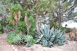
The Desert Garden is located near the hilltop and exhibits desert trees and succulents such as cacti, euphorbias and aloes. Some are native to Southern California, while others are endemic to Mexico, South Africa, and other desert regions of the world. Some species represented are Ponytail palm, Foxtail, Silver dollar plant, Jade plant, and a 7–8 feet tall Barbary fig.[25]
The Tranquility Garden was planted in Japanese garden style and showcases California native species. It was developed and dedicated in 1997.
Sage Hill features over one hundred native plant species.[26] The top of the hill features panoramic views of the entire Conejo Valley, including panorama views of Thousand Oaks, Newbury Park, the Simi Hills and the Santa Monica Mountains.[27]
Kids’ Adventure Garden has a tree house, zoo garden, dinosaur topiaries, fun paths, and creek access.[28]
Garden trails are found throughout the gardens. Little Loop Trail leads above the creek through chaparral and around a meadow. The longer, 1-mile (1.6km) Nature Trail follows the creek and descends into a shady, oak-canopied canyon just below the hill with the botanical gardens. After 1⁄4 mile (0.40km), steep wooden steps bring the path down into the canyon. After exploring the creek-bed for 1⁄2 mile (0.80km), the trail climbs out of the ravine and returns to the main garden area.[29][30]
↑ Weir, Kathie (2001). A Parent's Guide to Los Angeles: Friendly Advice for Touring Los Angeles with Children. Mars Publishing, Inc. Page 90. ISBN9780967512716.
↑ Tai, Lolly (2006). Designing outdoor environments for children: Landscaping schoolyards, gardens, and playgrounds. McGraw-Hill. Page 323. ISBN9780071459358.
↑ Russell, John J. and Thomas S. Spencer (2006). Gardens Across America, West of the Mississippi: The American Horticultural Society's Guide to American Public Gardens and Arboreta. Taylor Trade Publishing. Page 94. ISBN9781461708919.
↑ Popper, Helen (2012). California Native Gardening: A Month-by-Month Guide. University of California Press. Page 196. ISBN9780520952232.
↑ Russell, John J. and Thomas S. Spencer (2006). Gardens Across America, West of the Mississippi: The American Horticultural Society's Guide to American Public Gardens and Arboreta. Taylor Trade Publishing. Page 95. ISBN9781461708919.
This page is based on this Wikipedia article Text is available under the CC BY-SA 4.0 license; additional terms may apply. Images, videos and audio are available under their respective licenses.