
Conjola National Park covers 11,060 hectares and lies on the mid south coast of New South Wales, Australia, between Sussex Inlet and Lake Conjola, 165 km southwest of Sydney.

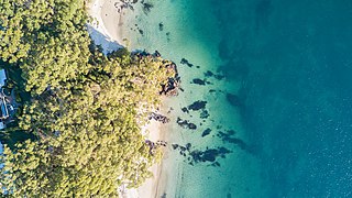
Jervis Bay is a 102-square-kilometre (39 sq mi) oceanic bay and village in the Jervis Bay Territory (ACT) and on the South Coast of New South Wales, Australia. In the Dhurga language of the Aboriginal inhabitants of the area, it is called Booderee, which translates as "bay of plenty".

Nowra is a city in the South Coast region of New South Wales, Australia. It is located 160 kilometres (99 mi) south-southwest of the state capital of Sydney. As of the 2021 census, Nowra has an estimated population of 22,584. Situated in the southern reaches of the Sydney basin, Nowra is the seat and commercial centre of the City of Shoalhaven.
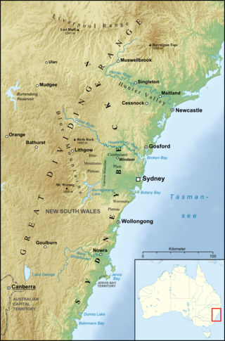
The Sydney Basin is an interim Australian bioregion and is both a structural entity and a depositional area, now preserved on the east coast of New South Wales, Australia and with some of its eastern side now subsided beneath the Tasman Sea. The basin is named for the city of Sydney, on which it is centred.

Lake Conjola is a small town situated on the South Coast of New South Wales, Australia. It is located in the region of Ulladulla, in the City of Shoalhaven. At the 2016 census, Lake Conjola had a population of 437. Lake Conjola is a popular tourist destination for boaters and fisherman. Fish in the lake include bream, whiting, tailor, flathead, luderick and jewfish. Lake Conjola is located on the southern side of Green Island, a renowned surf break. There are four caravan parks with cabins, caravan areas, tent areas, and waterfronts.
The South Coast refers to the narrow coastal belt from the Shoalhaven district in the north to the state border with Victoria in the south in the south-eastern part of the State of New South Wales, Australia. It is bordered to the west by the coastal escarpment of the Southern Tablelands, and is largely covered by a series of national parks, namely Jervis Bay National Park, Eurobodalla National Park, and Beowa National Park. To the east is the coastline of the Pacific Ocean, which is characterised by rolling farmlands, small towns and villages along a rocky coastline, interspersed by numerous beaches and lakes.

The geography of Sydney is characterised by its coastal location on a basin bordered by the Pacific Ocean to the east, the Blue Mountains to the west, the Hawkesbury River to the north and the Woronora Plateau to the south. Sydney lies on a submergent coastline on the east coast of New South Wales, where the ocean level has risen to flood deep river valleys (rias) carved in the Sydney sandstone. Port Jackson, better known as Sydney Harbour, is one such ria.

Sydney sandstone, also known as the Hawkesbury sandstone, yellowblock, and yellow gold, is a sedimentary rock named after Sydney, and the Hawkesbury River north of Sydney, where this sandstone is particularly common.

The 1994 eastern seaboard fires were significant Australian bushfires that occurred in New South Wales, Australia during the bushfire season of 1993–1994. Some 20,000 firefighters were deployed against some 800 fires throughout the state, and along the coast and ranges from Batemans Bay in the south to the Queensland border in the north, including populated areas of the city of Sydney, the Blue Mountains and the Central Coast. The fires caused mass evacuations of many thousands of people, claimed four lives, destroyed some 225 homes and burned out 800,000 hectares of bushland. The firefighting effort raised in response was one of the largest seen in Australian history.

The Wianamatta Group is a geological feature of the Sydney Basin, New South Wales, Australia that directly overlies the older Hawkesbury sandstone and generally comprise fine grained sedimentary rocks such as shales and laminites as well as less common sandstone units.
South Durras is a small village on the South Coast of New South Wales, Australia. South Durras is located approximately 280 kilometres south of Sydney and 15 kilometres north of Batemans Bay, in the local government area of Eurobodalla Shire. The village is surrounded by the Murramarang National Park.

Burrill Lake is a small village on the Princes Highway in the South Coast region of New South Wales, Australia. It is a seaside suburb of the Milton-Ulladulla district, a part of the City of Shoalhaven local government area and surrounds the lake of the same name. In 2021, Burrill Lake had a population of 1,782. The name of the town is derived from an Aboriginal word meaning 'wallaby'.
Geologically the Australian state of New South Wales consists of seven main regions: Lachlan Fold Belt, the Hunter-Bowen Orogeny or New England Orogen (NEO), the Delamerian Orogeny, the Clarence Moreton Basin, the Great Artesian Basin, the Sydney Basin, and the Murray Basin.

Ashfield Shale is part of the Wianamatta group of sedimentary rocks in the Sydney Basin. It lies directly on contemporaneously eroded Hawkesbury sandstone or the Mittagong formation. These rock types were formed in the Triassic Period. It is named after the Sydney suburb of Ashfield. Some of the early research was performed at the old Ashfield Brickworks Quarry. This rock type is often associated with the Inner West and North Shore of the city. However, it has also been recorded at Penrith, Revesby, Bilpin and Mount Irvine.

Bald Hill Claystone is a sedimentary rock found in the Sydney Basin in eastern Australia. It is part of the Clifton sub-group of the Narrabeen Group of sedimentary rocks. It was formed by weathering of the Gerringong Volcanics in the early Triassic. Named after Bald Hill, in the northern Illawarra, where it is 15 metres thick. The claystone is easily noticed at Long Reef, where it is 18 metres thick.

The Bokkeveld Group is the second of the three main subdivisions of the Cape Supergroup in South Africa. It overlies the Table Mountain Group and underlies the Witteberg Group. The Bokkeveld Group rocks are considered to range between Lower Devonian (Lochkovian) to Middle Devonian (Givetian) in age.

The Stone Fleet was the colloquial name for the small coastal ships that carried crushed-stone construction aggregate to Sydney from the Illawarra ports of Kiama and Shellharbour and the nearby ocean jetties at Bombo and Bass Point.

Milton Monzonite is a geologic formation in the Sydney Basin in eastern Australia. Formed in the early Triassic from an igneous intrusion, dated from 245 to 220 million years ago. Milton Monzonite is found in the southern coast areas of New South Wales near Milton. The soils derived from monzonite produce relatively fertile soils, and contribute to agriculture and the sub tropical rainforest at Yatteyattah, north of Milton. Surrounding and below the monzonite is the Conjola Formation, which are sedimentary rocks from the Permian.

Conjola Park is a beach resort in the City of Shoalhaven, New South Wales, Australia. It lies on the south shore of a lagoon called Conjola Lake, just to the east of the Princes Highway on Lake Conjola Entrance Road, which connects to the resort of Lake Conjola. It lies about 15 km north of Ulladulla and 215 km south of Sydney. At the 2016 census, it had a population of 340.

Yatte Yattah is a historically significant suburb on the South Coast of New South Wales. It is located on the Princes Highway about 4 km north of Milton and 2 km south of Conjola Lake. At the 2021 Census, the population was 189.
