
Beowa National Park, formerly Ben Boyd National Park, is a national park in New South Wales, Australia, 578 km (359 mi) south of Sydney. It was established in 1971 and officially renamed in 2022 owing to its previous namesake's connection with blackbirding. Beowa means "orca", an animal of significance to the traditional owners, the Thaua people.

The Morton National Park is a 199,745-hectare (493,580-acre) national park located in the Southern Highlands, South Coast and Illawarra regions of New South Wales, Australia, situated approximately 170 kilometres (110 mi) south southwest of Sydney.
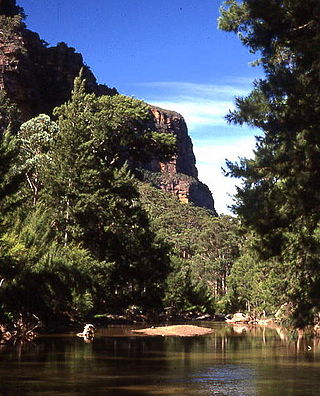
The Wollemi National Park is a protected national park and wilderness area that is located in the Central West and Hunter region of New South Wales, in eastern Australia. The 501,703-hectare (1,239,740-acre) park, the second largest national park in New South Wales, contains the 361,113-hectare (892,330-acre) Wollemi Wilderness – the largest such wilderness area in Australia – and is situated approximately 130 kilometres (81 mi) northwest of Sydney.

Milton is a village in the South Coast region of New South Wales, Australia, within the City of Shoalhaven. It was founded in 1860, named after the property of post master George Knight and became an important regional centre during the 19th Century. Today, Milton remains one of the two main commercial centres of the Milton-Ulladulla district, with a population at the 2016 census of 1,663. It is a popular stopping place for travellers on the Princes Highway which runs through the centre of town. In recent years, Milton has undergone a resurgence largely influenced by the local tourism industry and an influx of residents to the district seeking a seachange. Several new housing estates are being developed on the fringes of the village and new boutique stores, cafes and bed and breakfast type businesses have located in the town.
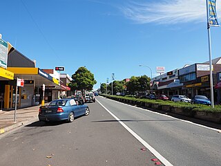
Ulladulla is a coastal town in New South Wales, Australia in the City of Shoalhaven local government area. It is on the Princes Highway about 230 kilometres (140 mi) south of Sydney, halfway between Batemans Bay to the south and Nowra to the north. Ulladulla has close links with the nearby historic settlement of Milton and many services are shared between these towns.

The Hunter Region, also commonly known as the Hunter Valley, Newcastle Region, or simply Hunter, is a region in northern New South Wales, Australia, extending from approximately 162 km (101 mi) to 310 km (193 mi) north of Sydney. It contains the Hunter River and its tributaries with highland areas to the north and south. Situated at the northern end of the Sydney Basin bioregion, the Hunter Valley is one of the largest river valleys on the NSW coast, and is most commonly known for its wineries and coal industry.
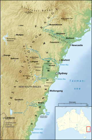
The Sydney Basin is an interim Australian bioregion and is both a structural entity and a depositional area, now preserved on the east coast of New South Wales, Australia and with some of its eastern side now subsided beneath the Tasman Sea. The basin is named for the city of Sydney, on which it is centred.

Barrenjoey is a locality in the suburb of Palm Beach, at the most northern tip of Pittwater. The headland is made up primarily of sandstones of the Newport Formation, the top third is a cap of Hawkesbury sandstone. Around 10,000 years ago the headland was cut off from the mainland due to the rising sea level; subsequent buildup of a sand spit or tombolo reconnected the island to the mainland. It is the location of the Barrenjoey Head Lighthouse, a lighthouse that was first lit in 1881. In 1995 Barrenjoey was gazetted into Ku-ring-gai Chase National Park.
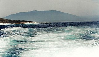
Gulaga, dual-named as Mount Dromedary and also referred to as Mount Gulaga, is a mountain located in the south coast region of New South Wales, Australia. It rises above the village of Central Tilba and is within the Gulaga National Park. At its highest point, it measures 806 metres (2,644 ft) above sea level.
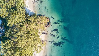
The South Coast refers to the narrow coastal belt from the Shoalhaven district in the north to the state border with Victoria in the south in the south-eastern part of the State of New South Wales, Australia. It is bordered to the west by the coastal escarpment of the Southern Tablelands, and is largely covered by a series of national parks, namely Jervis Bay National Park, Eurobodalla National Park, and Beowa National Park. To the east is the coastline of the Pacific Ocean, which is characterised by rolling farmlands, small towns and villages along a rocky coastline, interspersed by numerous beaches and lakes.

The geography of Sydney is characterised by its coastal location on a basin bordered by the Pacific Ocean to the east, the Blue Mountains to the west, the Hawkesbury River to the north and the Woronora Plateau to the south. Sydney lies on a submergent coastline on the east coast of New South Wales, where the ocean level has risen to flood deep river valleys (rias) carved in the Sydney sandstone. Port Jackson, better known as Sydney Harbour, is one such ria.

The Cumberland Plain, also known as Cumberland Basin, is a relatively flat region lying to the west of Sydney CBD in New South Wales, Australia. An IBRA biogeographic region, Cumberland Basin is the preferred physiographic and geological term for the low-lying plain of the Permian-Triassic Sydney Basin found between Sydney and the Blue Mountains, and it is a structural sub-basin of the Sydney Basin.

Ulladulla High School is a government-funded co-educational comprehensive secondary day school, located in the town of Ulladulla on the south-east coast of New South Wales, Australia.

The Yatteyattah Nature Reserve is a protected sub tropical rainforest in Yatte Yattah on the south coast of New South Wales, Australia. The 35-hectare (86-acre) reserve was formed from landed donated by a local farmer in the 1990s. The estimated elevation of the terrain is 546 meters.

Warden Head Light, also known as Ulladulla Lighthouse, is an active lighthouse on Warden Head, a headland south of Ulladulla, New South Wales, Australia, guarding the entrance to the Port of Ulladulla. It is one of only two wrought iron lighthouses in New South Wales, the other being its sibling, Wollongong Breakwater Lighthouse. It is also notable for two relocations: the tower was constructed in 1873 on the Ulladulla Breakwater, and relocated in 1889 to its current location. Its keeper's house was relocated to a different location in the 1920s.

The Milton Ulladulla Times is an English language newspaper published in Ulladulla, New South Wales, Australia. It is printed and published by Paul Poulus for the Milton-Ulladulla Publishing Co. Pty. Ltd.

Bulgo Sandstone is a sedimentary rock occurring in the Sydney Basin in eastern Australia. This stratum is up to 100 metres thick, formed in the early Triassic (Olenekian). A component of the Narrabeen Group of sedimentary rocks. It consists of layers of fine to medium-grained quartz-lithic sandstone, with lenticular shale interbeds.

The Conjola Formation is a geologic formation in the south of the Sydney Basin in eastern Australia. Formed in the late Permian, when the Wagonga Beds sank below sea level, and were subsequently covered with eroded sediments. A member of the Shoalhaven Group, the maximum depth is 550 metres, the age is between 264 and 265 million years. Within this formation the rocks contain mid to dark-grey siltstone of an indistinct bedding to flat-bedding. With very fine feldspathic lithic sandstone, and thin layers of lenses of fine-grained sandstone.

The Illawarra-Shoalhaven subtropical rainforest, or Illawarra Subtropical Rainforest (ISR), is a scattered rainforest community in the Illawarra region of New South Wales, Australia. Occurring just south of Sydney, it spans from the Royal National Park (north of Wollongong) to the Milton-Ulladulla district in the south, albeit in scattered fragments.

Yatte Yattah is a historically significant suburb on the South Coast of New South Wales. It is located on the Princes Highway about 4 km north of Milton and 2 km south of Conjola Lake. At the 2021 Census, the population was 189.
