
County Cork is the largest and the southernmost county of Ireland, named after the city of Cork, the state's second-largest city. It is in the province of Munster and the Southern Region. Its largest market towns are Mallow, Macroom, Midleton, and Skibbereen. As of 2022, the county had a population of 584,156, making it the third-most populous county in Ireland. Cork County Council is the local authority for the county, while Cork City Council governs the city of Cork and its environs. Notable Corkonians include Michael Collins, Jack Lynch, Roy Keane, Sonia O'Sullivan, Cillian Murphy and Graham Norton.

Skibbereen is a town in County Cork, Ireland. It is located in West Cork on the N71 national secondary road. The River Ilen runs through the town; it reaches the sea about 12 kilometres away, at the seaside village of Baltimore. Located in a tourist area, Tragumna beach is nearby.
Aghabullogue or Aghabulloge is a village and parish in the barony of Muskerry East in County Cork, Ireland. It lies around 30 km (19 mi) west of Cork City, south of the Boggeragh Mountains and north of the River Lee.

Monkstown is a village in County Cork, Ireland, in the old barony of Kerrycurrihy. It lies 14 kilometres southeast of Cork city on the estuary of the River Lee, facing Great Island and looking onto Monkstown Bay. For census purposes, Monkstown is combined with the nearby town of Passage West, and the combined area has a population of approximately 5,800 residents. The village is in a townland and civil parish of the same name. The Catholic parish of Monkstown includes the nearby villages of Shanbally and Ringaskiddy.
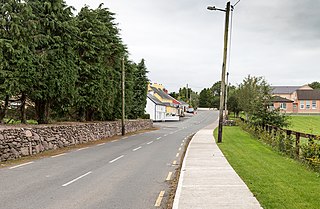
The twin villages of Ballineen and Enniskeane, or Enniskean, in County Cork in Ireland are 43 km (26.72 mi) southwest of Cork City, on the R586 road. The linear settlement lies on the River Bandon between Bandon and Dunmanway. The combined settlement is designated as a 'key village' by Cork County Council for planning purposes and, as of the 2016 census, had a population of 692 people.

Durrus is a village and civil parish in West Cork in Ireland. It is situated ten kilometres (6 mi) from Bantry in County Cork, at the head of the Sheep's Head and the Mizen Head peninsulas.

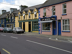
Kilbrittain or Killbrittain is the name of a village, townland and parish in County Cork, Ireland. The village is about 8 kilometres (5 mi) south of Bandon, and near Courtmacsherry and Timoleague. The coastal route around the edge of the parish is the R600 road. The village itself is around 3 kilometres (1.9 mi) inland from the coast.
Rostellan is a civil parish, townland and village in the historical Barony of Imokilly, County Cork, Ireland. An electoral division of the same name forms part of the Cork East Dáil constituency. For census purposes, the village of Rostellan is combined with the neighbouring villages of Farsid and Aghada. As of the 2011 census, the combined settlement of Aghada-Farsid-Rostellan had a population of 1,015 people.

Clondrohid is a village and civil parish in County Cork, Ireland, four miles (6 km) north of Macroom. As of the 2022 census, the population of the village was recorded as 180, down slightly from 188 people as of the 2011 census.

Derrymeeleen is a townland in the civil parish of Desertserges, County Cork, Ireland. The total population in 2011 for this townland was 70, of which males numbered 40 and females were 30. The total housing stock was 21 of which vacant households numbered 0. It is situated at a height of more than 100 metres above the River Bandon.
Ballyvoige is a townland in the civil parish of Desertserges, County Cork, Ireland. It has an area of approximately 279 acres (113 ha). Archaeological sites in Ballyvoige include a ringfort and souterrain.
Bantry is a barony in the west of County Cork in Ireland. Patrick Weston Joyce said the name Beanntraí means "descendants of Beann [Ban]", a son of Conchobar mac Nessa; similarly for the Wexford barony of Bantry. The barony borders the top end the southern shore of Bantry Bay. On the opposite shore is the barony of Bear. It is also bordered by Carbery West and Muskerry West to the northeast. To the north is County Kerry.
Carbery East is a barony in County Cork in Ireland. It has been split since the nineteenth century into East and West Divisions.
Carbery West is a barony in County Cork in Ireland. It has been split since the nineteenth century into East and West Divisions.
A list of lists of townlands in County Cork, Ireland by barony: there are approximately 5,580 townlands.
Muskerry West is one of the baronies of Ireland, a historical geographical unit of land. Its chief town is Macroom. It is one of 24 baronies in the county of Cork. It may also be viewed as a half barony because sometime before the 1821 census, it was divided from its other half – Muskerry East. Other neighbouring baronies include Duhallow to the north and the Barony of Carbery East to the south.
Muskerry East is one of the baronies of Ireland, an historical geographical unit of land. Its chief town is Ballincollig. It is one of 24 baronies in the county of Cork. It may also be viewed as a half barony because some time before the 1821 census data, it was divided from its other half - Muskerry West. Other neighbouring baronies include Cork to the east, Duhallow to the north and the barony of Barretts to the north-east.

Aghavrin is a townland within both the civil parish and Catholic parish of Aghabullogue, County Cork, Ireland. It is approximately 667.3 acres (2.7 km2) in size, situated south-west of Aghabullogue village, and north-west of Coachford village.
Ardraly is a townland located in the barony of West Carbery, in County Cork, Ireland. Archival records of 1601 list Ardrawly from the Calendar to Fiants of reign of Henry VIII.

Castlefreke, also known as Rathbarry, is a townland and village in County Cork, Ireland. The townland is located in the civil parish of Rathbarry on the R598 regional road, to the east of Rosscarbery.

