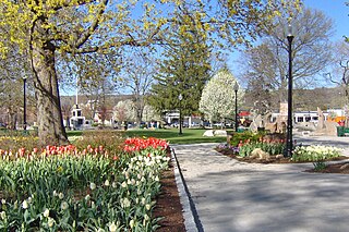
Torrington is the most populated municipality and largest city in Litchfield County, Connecticut, United States, and the Northwest Hills Planning Region. It is also the core city of Greater Torrington, one of the largest micropolitan areas in the United States. The city population was 35,515 according to the 2020 census. The city is located roughly 23 miles (37 km) west of Hartford, 34 miles (55 km) southwest of Springfield, Massachusetts, 67 miles (108 km) southeast of Albany, New York, 84 miles (135 km) northeast of New York City, and 127 miles (204 km) west of Boston, Massachusetts.

U.S. Route 5 (US 5) is a north–south United States Numbered Highway running through the New England states of Connecticut, Massachusetts, and Vermont. Significant cities along the route include New Haven, Connecticut; Hartford, Connecticut; and Springfield, Massachusetts. From Hartford northward to St. Johnsbury, Vermont, the road closely follows the route of the Connecticut River.

U.S. Route 202 (US 202) is a spur route of US 2. It follows a northeasterly and southwesterly direction stretching from Delaware in the south to Maine in the north and traveling through the states of Pennsylvania, New Jersey, New York, Connecticut, Massachusetts, and New Hampshire. The highway has borne the number 202 since at least 1936. Before this, sections of the highway were designated U.S. Route 122, as it intersected US 22 in New Jersey. It intersects its parent route, US 2, in Bangor, Maine.
U.S. Route 3 (US 3) is a United States Numbered Highway running 277.90 miles (447.24 km) from Cambridge, Massachusetts, through New Hampshire, to the Canada–United States border near Third Connecticut Lake, where it connects to Quebec Route 257.
U.S. Route 65 is a north–south United States highway in the southern and midwestern United States. The southern terminus of the route is at U.S. Route 425 in Clayton, Louisiana. The northern terminus is at Interstate 35 just south of Interstate 90 in Albert Lea, Minnesota. Parts of its modern route in Iowa and historic route in Minnesota follow the old Jefferson Highway.

Route 8 is a 67.36-mile (108.41 km) state highway in Connecticut that runs north–south from Bridgeport, through Waterbury, all the way to the Massachusetts state line where it continues as Massachusetts Route 8. Most of the highway is a four-lane freeway but the northernmost 8.8 miles (14.2 km) is a two-lane surface road.
Route 8 is the portion of the 148 mile multistate New England Route 8 within the state of Massachusetts. The highway runs 66.643 miles (107.252 km) from the Connecticut state line in Sandisfield, where the highway continues as Connecticut Route 8, north to the Vermont state line in Clarksburg, where the highway continues as Vermont Route 8 and VT 100. Route 8 serves several towns in eastern and northern Berkshire County. The highway is the main highway between the cities of Pittsfield and North Adams, where the route intersects Route 9 and Route 2, respectively. Route 8 also intersects U.S. Route 20 in Becket.

Route 20 is a 31.56-mile (50.79 km) state highway in the U.S. state of Connecticut. It extends from Route 8 in rural Winchester to Interstate 91 (I-91) in Windsor Locks. Route 20 consists of two distinct sections: a long, winding, scenic rural road, and a section of the freeway linking I-91 to Bradley International Airport.

Route 4 is an east–west primary state highway connecting rural Litchfield County to the Greater Hartford area of the U.S. state of Connecticut. It runs 46.72 miles (75.19 km) from the town of Sharon to the town of West Hartford.

Route 63 is a secondary state highway in the U.S. state of Connecticut, from New Haven up to Canaan, running for 52.57 miles (84.60 km). It connects the Greater New Haven area to Northwestern Connecticut via the western suburbs of Waterbury.
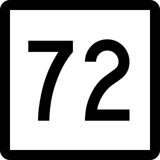
Route 72 is a state highway in the western part of the Greater Hartford area. Route 72 is an L-shaped route with a north–south section in Plymouth and Harwinton and an east–west section from Bristol to New Britain. Route 72 is a freeway from Route 9 in New Britain to Route 372 in Plainville. Although ConnDOT logs it as a north-south route, it is signed as east-west.

Route 83 is a 35.65-mile-long (57.37 km) north–south state highway in the Greater Hartford and Greater Springfield areas of the U.S. states of Connecticut and Massachusetts. It serves as the main north–south artery for the towns of Manchester, Vernon, Ellington, and Somers, and continues through East Longmeadow center into downtown Springfield. The route in Massachusetts is town-maintained, except for the ramps connecting to U.S. Route 5 parallel to Interstate 91.

Route 169 is a 47.36-mile-long (76.22 km) state highway in the U.S. states of Connecticut and Massachusetts. It begins in the city of Norwich, Connecticut, and runs 38 miles (61 km) through Northeastern Connecticut, continuing across the state line into Southbridge, Massachusetts. The route ends in Charlton after another nine miles (14 km). A portion of the route in the town center of Pomfret is on the National Register of Historic Places as Pomfret Street Historic District, and 32.10 miles (51.66 km) of the road is designated as the Connecticut State Route 169 National Scenic Byway.

Connecticut Route 10 is a state highway that runs from Interstate 95 (I-95) in New Haven Massachusetts state line, where it continues as Massachusetts Route 10, which in turn continues directly to New Hampshire Route 10.

Route 116 is a 68.26-mile-long (109.85 km) north–south state highway in Massachusetts. The route runs from Route 20A in Springfield through mill towns, college towns and rural towns, crossing the Connecticut River three times before finally ending at Route 8 in Adams.

In Connecticut, U.S. Route 202 is usually signed as an east–west route. It enters from the New York state line in Danbury overlapped with U.S. Route 6 and ends at the Massachusetts state line in Granby overlapped with Route 10. Although the route serves no major city centers for most of its run, with the largest city being Danbury, it does pass through Hartford County, serving the northern fringe of Greater Hartford. US 202 is overlapped with other routes for most of its length.
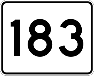
Massachusetts Route 183 (MA 183) is a 31.94-mile-long (51.40 km) north–south state highway in Berkshire County, Massachusetts. The entire route travels from a continuation of Connecticut Route 183 by Colebrook, Connecticut, to U.S. Route 7 and US 20 in Lenox.

Route 272 is a state highway in northwestern Connecticut running from Torrington to the Massachusetts state-board in Norfolk.

U.S. Route 7 (US 7) in of Massachusetts is a 54-mile (87 km) section of the larger federal route extending from southern Connecticut to the northernmost part of Vermont. The entire route in Massachusetts is within Berkshire County.
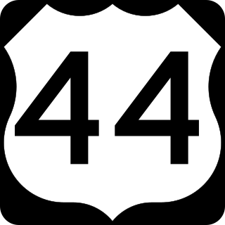
U.S. Route 44 (US 44) is an east–west United States Numbered Highway that runs for 237 miles (381 km) through four states in the Northeastern United States. The western terminus is at US 209 and New York State Route 55 (NY 55) in Kerhonkson, New York, a hamlet in the Hudson Valley region. The eastern terminus is at Route 3A in Plymouth, Massachusetts.


