Console Springs

Last updated
Console Springs
"Console Water" The Pomona Daily Review, August 25, 1906.jpg
"Console Water" Pomona Daily Review, August 25, 1906
Console Springs
Coordinates 33°59′00″N117°13′02″W / 33.9833°N 117.2172°W / 33.9833; -117.2172

Console Springs was a natural spring in Reche Canyon, Riverside County (originally San Bernardino County), [1] California, United States. [2] The waters were bottled for sale in the early 20th century. [3]

Contents

History

The springs were named for the Console family that owned them. [4] John Console (~1862–1926) settled in the canyon in 1894. [5] Console built the canyon schoolhouse; water for the students was toted from the spring. [6] Console sold the bottled water out of a "wagon on 3rd Street" but "sales were slow." [7] He also sold holly (possibly actually native toyon) out of his wagon around Christmastime. [8] A native of Sicily, Console was a stone mason by trade. [9]

"Historic Reche Canyon--Path to the Past" (San Bernardino County Sun, Dec. 15, 1959) Historic Reche Canyon--Path to the Past - CNDC at UCR - The San Bernardino County Sun Tue Dec 15 1959.jpg
"Historic Reche Canyon—Path to the Past" (San Bernardino County Sun, Dec. 15, 1959)

There was no associated resort hotel but circa 1914 there were campsites nearby for visitors. [10] California boosters claimed the spring water had medicinal value and would be beneficial for people with rheumatism, Bright's disease, and liver disorders. [11] In 1976, Console's son recalled, "We used to have a tent set up at the spring and doctors would bring patients in to recuperate beside the mineral water. Everything was green and there was a flower garden out there." [12] According to John Console Jr. "city people would drive up in horse-drawn buggies for picnics." [12]

In 1925, during the Prohibition era, John Console was arrested on charges of illegally selling liquor at dances held at the springs. According to the Riverside Daily Press, "When asked at the county jail if he had any remarks to make when he was being booked, Console said, 'Seventeen kids and no money in the bank.'" [8]

John Console and his family, 1907 John Console and his family - LATIMES - page II-13 - Thursday, May 02, 1907.jpg
John Console and his family, 1907

Water profile

According to a U.S. government geologist in 1915, "On the granitic slopes a few miles east of Riverside there are a few small springs that have been utilized. One of these, which is known as Console Spring, issues in Reche Canyon, about 9 miles in a direct line east of Riverside, and yields perhaps 7 gallons a minute. The water was placed on the local market in 1906 as a table water. A partial analysis, published in advertising matter, indicates that the water contains about 250 parts per million of solids in solution, sodium, carbonate, and sulphate being the principal constituents." [13]

See also

Related Research Articles

<span class="mw-page-title-main">Highgrove, California</span> Census-designated place in California, United States

Highgrove is a census-designated place (CDP) and an unincorporated community in Riverside County, California, United States. The population was 3,988 at the 2010 census, up from 3,445 at the 2000 census. The latest 2020 census shows 7,515 total population, an 88.4% increase from last 2010 census, which makes it the fastest-growing location in entire Riverside County.

<span class="mw-page-title-main">San Bernardino Mountains</span> Mountain range of the Transverse Ranges in California, United States

The San Bernardino Mountains are a high and rugged mountain range in Southern California in the United States. Situated north and northeast of San Bernardino and spanning two California counties, the range tops out at 11,503 feet (3,506 m) at San Gorgonio Mountain – the tallest peak in Southern California. The San Bernardinos form a significant region of wilderness and are popular for hiking and skiing.

<span class="mw-page-title-main">Colton Joint Unified School District</span> School district in California, United States

The Colton Joint Unified School District (CJUSD) is a school district in California.

<span class="mw-page-title-main">Searles Lake</span> Lake in the state of California, United States

Searles Lake is an endorheic dry lake in the Searles Valley of the Mojave Desert, in northwestern San Bernardino County, California. The lake in the past was also called Slate Range Lake and Borax Lake.

<span class="mw-page-title-main">Whitewater River (California)</span> Stream in California, United States

The Whitewater River is a small permanent stream in western Riverside County, California, with some upstream tributaries in southwestern San Bernardino County. The river's headwaters are in the San Bernardino Mountains, and it terminates at the Salton Sea in the Colorado Sonoran Desert. The area drained by the Whitewater River is part of the larger endorheic Salton Sea drainage basin.

<span class="mw-page-title-main">California's 41st congressional district</span> U.S. House district for California

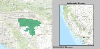
California's 41st congressional district is a congressional district in Riverside County, in the U.S. state of California. The district is currently represented by Republican Ken Calvert.

Today's Bradshaw Trail is a historic overland stage route in the western Colorado Desert of Southern California. It is a remnant of the much longer Bradshaw Road, also known as the Road to La Paz, or Gold Road, established in 1862 by William D. Bradshaw. It was the first overland route to connect the gold fields near La Paz in the U.S. New Mexico Territory, later the Arizona Territory, to Southern California's more populated west coast. Once in La Paz, additional roads provided access to the mining districts of the central New Mexico/Arizona Territory, near Wickenburg and Prescott.

<span class="mw-page-title-main">San Timoteo Canyon</span> Landform in Riverside and San Bernardino Counties, California

San Timoteo Canyon is a river valley canyon southeast of Redlands, in the far northwestern foothills of the San Jacinto Mountains in the Inland Empire region of Southern California.

<span class="mw-page-title-main">Box Springs, California</span> Unincorporated community in California, United States

The Box Spring is a spring in Riverside County, California, around which grew the town of Box Springs. It is in the Moreno Valley, five miles (8.0 km) east-southeast of downtown Riverside on Interstate 215/State Route 60. Box Springs is named on the 7.5 quadrangle map, Riverside East (1967).

<span class="mw-page-title-main">Gilman Hot Springs</span> Thermal springs in California

Gilman Hot Springs, also known as San Jacinto Hot Springs or the Relief Springs, is a hot spring system in the Inland Empire area of Southern California. Located near Potrero Creek, the San Jacinto River, and California State Route 79, the springs system consists of "about half a dozen" springs named for the Mexican land grant Rancho San Jacinto Viejo.

<span class="mw-page-title-main">Falling Springs, California</span> Archaic placename, Angeles National Forest

Falling Springs is an archaic placename in Los Angeles County, California. Falling Springs was the site of rustic resorts located along the north fork of the San Gabriel River in the San Gabriel Mountains along Soldier Creek, 12 miles (19 km) north-northeast of Azusa, in close proximity to Crystal Lake Recreation Area in the Angeles National Forest.

The Perris Block is the central block of three major fault-bounded blocks of the northern part of the Peninsular Ranges. The Perris Block lies between the Santa Ana Block to the west and the San Jacinto Block to the east. The Perris Block, was named by Walter A. English in 1925 for the city of Perris, located near the center of the block.

<span class="mw-page-title-main">Reche Canyon</span> Canyon in southern California, United States

Reche Canyon is a canyon in the far northwestern foothills of the San Jacinto Mountains, northwest of The Badlands in the Inland Empire region of Southern California. The Tongva village of Homhoangna, from which the canyon's alternative names derives, was located here. The county line between San Bernardino County and Riverside County is at the approximate midway point of the canyon; the San Bernardino half to the north is mostly within the boundaries of Colton, with a small area in Loma Linda, while the southern half is unincorporated territory of Riverside County. Reche Canyon Elementary School is located in the northern part of the canyon.

<span class="mw-page-title-main">Homhoangna</span> Tongva populated place

Homhoangna was a Tongva village located at what is now the area in-between the Santa Ana River, Colton Avenue, and the Southern Pacific Railroad. The village is associated with the area of Colton, California.

<span class="mw-page-title-main">Potrero Creek</span> San Jacinto River tributary, California, U.S.

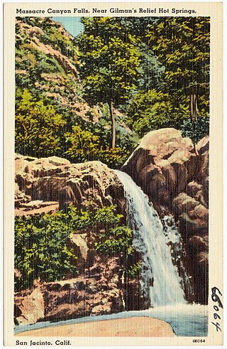
Potrero Creek is a minor waterway of Riverside County, California in the United States. Potrero Creek has a 5-mile (8.0 km)-long course and flows south through the San Jacinto River basin. Potrero Creek drains about 35 square miles (91 km2) of the San Jacinto Mountains. Potrero joins the San Jacinto River near California State Route 79, at Gilman Hot Springs, California. There are reportedly a small group of cave shelters along Potrero Creek in Massacre Canyon, south of Beaumont, on what was called the Stanton Ranch in 1962. Massacre Canyon supposedly gets its name from a battle that took place around 1540, when Temecula people massacred defenders of a village of the tribe now known as the Soboba Band of Luiseño Indians, which was called Ivah and was located at what is now Gilman Hot Springs, California.

<span class="mw-page-title-main">Soboba Hot Springs</span> Geothermal site in California

Soboba Hot Springs are a historic hot springs and resort in Riverside County, California, United States. The springs issued from the side of a steep ravine "with narrow, precipitous sides, and the rock exposed is largely a crushed gneiss...the thermal character of the springs is due to crushing and slipping of the rocks". The Soboba Hot Springs resort was adjacent to the reservation of the Soboba Band of Luiseño Indians. Soboba means hot water in the Luiseño language.

<span class="mw-page-title-main">Eden Hot Springs</span> Geothermal site in California

Eden Hot Springs was a historic hot springs and resort in Riverside County, California, United States.

<span class="mw-page-title-main">Urbita Hot Springs</span> Geothermal site in California

Urbita Hot Springs was a historic hot springs and amusement park in San Bernardino County, California, United States. Urbita Springs Park was located between E Street and Colton Street in San Bernardino where the Inland Center mall stands today.

<span class="mw-page-title-main">Veronica Springs</span> Historic mineral spring, California

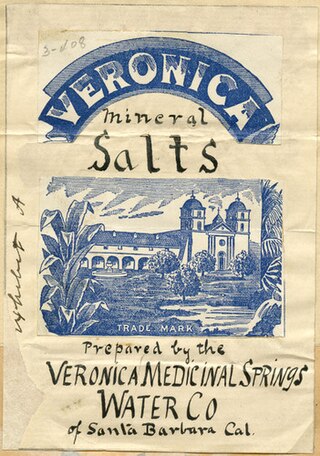
Veronica Springs, also Veronica Medicinal Springs, was a cluster of natural springs along Arroyo Burro creek in Santa Barbara County, California, United States. Veronica spring water was not a therapeutic spa water or a table water but a medicinal mineral water with high magnesium levels. The waters had a yellowish tinge and a strongly purgative-laxative effect, and beginning around 1887, the water was bottled and sold as a health tonic. Veronica Water peaked as a brand in the 1910s. The springs were capped off in 1962.

References

  1. Gunther, Jane Davies (1984). Riverside County, California, Place Names: Their Origins and Their Stories. J.D. Gunther. p. 185.
  2. U.S. Geological Survey Geographic Names Information System: Console Springs
  3. Sanford, Samuel (1911). "Mineral waters". Mineral resources of the United States, 1909: Part II – Nonmetals. Mineral Resources of the United States. Washington, DC: United States Geological Survey. p. 870. doi:10.3133/70175795.
  4. "Reche Canyon". www.sbcity.org. Retrieved 2024-02-17.
  5. "Death of John Console". Riverside Daily Press. 1926-08-20. p. 5. Retrieved 2024-02-19.
  6. "Reche Canyon". Riverside Daily Press. 1951-10-04. p. 26. Retrieved 2024-02-17.
  7. "They Tell Me". The San Bernardino County Sun. 1965-12-07. p. 20. Retrieved 2024-02-17.
  8. 1 2 "Officers Raid Console Springs". Riverside Daily Press. 1925-08-13. p. 8. Retrieved 2024-02-19.
  9. Teters, Beth (1951-10-03). "History of Reche Canyon a Mantle of Many Hues". Riverside Daily Press. p. 13. Retrieved 2024-02-19.
  10. Southern California Panama Expositions Commission (1914). Southern California: Comprising the Counties of Imperial, Los Angeles, Orange, Riverside, San Bernardino, San Diego, Ventura. Southern California Panama Expositions Commission. p. 161.
  11. Evans, Thomas C. (April 1907). "Healing Springs of Riverside County". For California: A Monthly Publication. Springs Number. Vol. IV, no. 5. San Francisco: California Promotion Committee. p. 5. hdl:2027/mdp.39015082352025 via Biodiversity Heritage Library and HathiTrust.
  12. 1 2 Cooper, Steve (1976-03-21). "Time, Not Work, Aged John Console". The San Bernardino County Sun. p. 19. Retrieved 2024-02-19. & "Time Takes Toll [part 2 of 2]". The San Bernardino County Sun. 1976-03-21. p. 22. Retrieved 2024-02-19.
  13. Waring, Gerald Ashley (January 1915). Springs of California. U.S. Department of the Interior, Geological Survey Water-Supply Papers. Washington, D.C.: U.S. Government Printing Office. p. 352. doi:10.3133/wsp338. Water Supply Paper No. 338. Retrieved 2024-02-16 via HathiTrust.PD-icon.svg This article incorporates text from this source, which is in the public domain .