
The Tongva are an Indigenous people of California from the Los Angeles Basin and the Southern Channel Islands, an area covering approximately 4,000 square miles (10,000 km2). In the precolonial era, the people lived in as many as 100 villages and primarily identified by their village rather than by a pan-tribal name. During colonization, the Spanish referred to these people as Gabrieleño and Fernandeño, names derived from the Spanish missions built on their land: Mission San Gabriel Arcángel and Mission San Fernando Rey de España. Tongva is the most widely circulated endonym among the people, used by Narcisa Higuera in 1905 to refer to inhabitants in the vicinity of Mission San Gabriel. Some people who identify as direct lineal descendants of the people advocate the use of their ancestral name Kizh as an endonym.

Colton is a city in San Bernardino County, California, United States. Nicknamed "Hub City", Colton is located in the Inland Empire region of the state and is a suburb of San Bernardino, approximately 4 miles (6.4 km) south of the city's downtown. The population of Colton is 52,154 according to the 2010 census, up from 47,662 at the 2000 census.

The San Gabriel River is a mostly urban waterway flowing 58 miles (93 km) southward through Los Angeles and Orange Counties, California in the United States. It is the central of three major rivers draining the Greater Los Angeles Area, the others being the Los Angeles River and Santa Ana River. The river's watershed stretches from the rugged San Gabriel Mountains to the heavily developed San Gabriel Valley and a significant part of the Los Angeles coastal plain, emptying into the Pacific Ocean between the cities of Long Beach and Seal Beach.

The Crescenta Valley is a small inland valley in Los Angeles County, California, lying between the San Gabriel Mountains on the northeast and the Verdugo Mountains and San Rafael Hills on the southwest. It opens into the San Fernando Valley at the northwest and the San Gabriel Valley at the southeast. It is nearly bisected by the Verdugo Wash, a smaller valley separating the Verdugo Mountains from the San Rafael Hills. Most of the valley lies at an elevation of over 1,500 feet.

The San Bernardino Valley is a valley in Southern California located at the south base of the Transverse Ranges. It is bordered on the north by the eastern San Gabriel Mountains and the San Bernardino Mountains; on the east by the San Jacinto Mountains; on the south by the Temescal Mountains and Santa Ana Mountains; and on the west by the Pomona Valley. Elevation varies from 590 feet (180 m) on valley floors near Chino to 1,380 feet (420 m) near San Bernardino and Redlands. The valley floor is home to over 80% of the more than 4 million people in the Inland Empire region.
The Hahamog'na, commonly anglicized to Hahamongna and spelled Xaxaamonga in their native language, are a tribe of the Tongva people of California. Their language belongs to the Uto-Aztecan family.

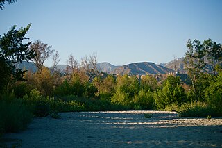
Tujunga Wash is a 13-mile-long (20.9 km) stream in Los Angeles County, California. It is a tributary of the Los Angeles River, providing about a fifth of its flow, and drains about 225 square miles (580 km2). It is called a wash because it is usually dry, especially the lower reaches, only carrying significant flows during and after storms, which usually only occur between November and April. The name of the wash derives from a Tongva village name.

The Tongva Sacred Springs are a group of springs located on the campus of University High School in Los Angeles, California. The springs, called Koruuvanga by the native Gabrieleno Tongva people, were used as a source of natural fresh water by the Tongva people since at least the 5th century BC and continue to produce 22,000–25,000 US gallons (83,000–95,000 L) of water a day. The springs are also sometimes referred to as the Gabrieleno-Tongva Springs, the Tongva Holy Springs, and the Sacred Springs.
Hahamongna and Hahamog-na are historic Tongva villages located in the Verdugo Mountains of Southern California named after the local Tongva band's name Hahamog'na. The village sites are located in present-day Pasadena and Glendale in Los Angeles County, California. Hahamongna was one of the largest Tongva villages in the greater San Fernando Valley area, along with Cahuenga, Tujunga, and Siutcanga.
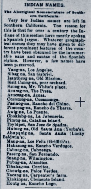
Pasinogna is a former Tongva-Gabrieleño Native American settlement in San Bernardino County, California.
Tuyunga or Tujunga is a former Tongva (Fernandeño) village now located at Sunland-Tujunga, Los Angeles in Los Angeles County, California. The village was located near the original Rancho Los Encinos that became the Mission San Fernando Rey de España in the San Fernando Valley.
Brea Creek is one of four principal tributaries of Coyote Creek, which is a lower tributary of the San Gabriel River in California. It drains parts of Orange, Riverside, and San Bernardino counties. The creek flows 11.7 miles (18.8 km) from the cities of Brea and Anaheim to Whittier, where its mouth is on the left bank of Coyote Creek, at a point 481 feet (147 m) lower in elevation.
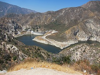
Big Tujunga Dam is a 244-foot-high (74 m) concrete arch dam in Los Angeles County, California, spanning Big Tujunga Canyon northeast of Sunland, in the foothills of the San Gabriel Mountains. Completed in 1931, it provides flood control and groundwater recharge for the San Fernando Valley.

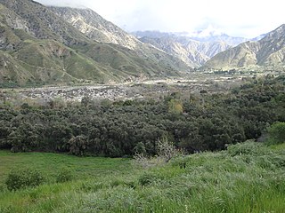
Reche Canyon is a canyon in the far northwestern foothills of the San Jacinto Mountains, northwest of The Badlands in the Inland Empire region of Southern California. The Tongva village of Homhoangna, from which the canyon's alternative names derives, was located here. The county line between San Bernardino County and Riverside County is at the approximate midway point of the canyon; the San Bernardino half to the north is mostly within the boundaries of Colton, with a small area in Loma Linda, while the southern half is unincorporated territory of Riverside County. Reche Canyon Elementary School is located in the northern part of the canyon.

Kaawchama, alternatively referred to as Wa’aachnga, was a significant Tongva village in the San Bernardino Valley located in what is now west Redlands, California. The village became referred to by the Spanish as the Guachama Rancheria in 1810 after a supply station was constructed at the village for Mission San Gabriel, which then became part of Rancho San Bernardino following the secularization of the missions in 1833.

Puhú was a major residential village in the Santa Ana Mountains shared by the Tongva, Acjachemen, Payómkawichum, and Serrano near Santiago Peak. The village resided approximately 600m above sea level in the upper areas of the Black Star Canyon. The village was at its height from the years 1220–1770. The village retained its multi-seasonal occupancy and economic and political systems up until its destruction and a communal massacre in 1832.
Genga, alternative spelling Gengaa and Kengaa, was a Tongva and Acjachemen village located on Newport Mesa overlooking the Santa Ana River in the Newport Beach and Costa Mesa, California area which included an open site now referred to as Banning Ranch. Archaeological evidence dates the village at over 9,000 years old. Villagers were recorded as Gebit in Spanish Mission records. The village may have been occupied as late as 1829 or 1830.
Hutuknga was a large Tongva village located in the foothills along the present channel of the Santa Ana River in what is now Yorba Linda, California. People from the village were recorded in mission records as Jutucabit. Hutuknga was part of a series of villages along the Santa Ana River, which included Lupukngna, Genga, Pajbenga, and Totpavit. The Turnball Canyon area is sometimes falsely associated with Hutuknga.

Moyongna, alternatively spelled Moyonga, was a coastal Tongva village or landmark site located near the entrance of Newport Bay in Newport Beach, California near Corona del Mar. As a coastal village, the usage of te'aats was likely important to the village's people. Nearby coastal villages included Genga, located on Newport Mesa, and Lupukngna, located near the mouth of the Santa Ana River.
Wapijanga was a Tongva village located in what is now Chino Hills, California, between the San Gabriel Mountains and Saddleback Peak. The village was located along Chino Creek, upstream from the village of Pashiinonga. It has been alternatively referred to as Wajijanga and Wapijangna. It was recorded as a large village in San Gabriel Mission records.
