Related Research Articles

The establishment of the Roanoke Colony was an attempt by Sir Walter Raleigh to found the first permanent English settlement in North America. The colony was first founded in 1585, but after only five years, when a ship visited the colony in 1590, the colonists had disappeared without explanation. The colony has since been known as the Lost Colony, and the fate of the 112 to 121 colonists remains unknown to this day.

Ventura County is a county in the southern part of the U.S. state of California. As of the 2020 census, the population was 843,843. The largest city is Oxnard, and the county seat is the city of Ventura.

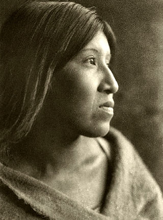
The Tongva are an Indigenous people of California from the Los Angeles Basin and the Southern Channel Islands, an area covering approximately 4,000 square miles (10,000 km2). In the precolonial era, the people lived in as many as 100 villages and primarily identified by their village rather than by a pan-tribal name. During colonization, the Spanish referred to these people as Gabrieleño and Fernandeño, names derived from the Spanish missions built on their land: Mission San Gabriel Arcángel and Mission San Fernando Rey de España. Tongva is the most widely circulated endonym among the people, used by Narcisa Higuera in 1905 to refer to inhabitants in the vicinity of Mission San Gabriel. Some direct lineal descendants of the people advocate the use of their ancestral name Kizh as an endonym.

La Crescenta-Montrose is an unincorporated area in Los Angeles County, California, United States. The community is bordered by Glendale to the south and west, La Cañada Flintridge to the east, and Angeles National Forest to the north. According to the United States Census Bureau, the La Crescenta-Montrose Census-Designated Place (CDP) measures about 3.4 square miles (8.8 km2), and the population was 19,997 at the 2020 census, up from 19,653 in 2010 and 18,532 in 2000.

Cashmere is a city in Chelan County, Washington, United States. It is part of the Wenatchee–East Wenatchee Metropolitan Statistical Area. The population was 3,248 at the 2020 census.

The San Fernando Valley, known locally as the Valley, is an urbanized valley in Los Angeles County, California. Situated to the north of the Los Angeles Basin, it contains a large portion of the City of Los Angeles, as well as unincorporated areas and the incorporated cities of Burbank, Calabasas, Glendale, Hidden Hills, and San Fernando. The valley is well known for its iconic film studios such as Warner Bros. Studio and Walt Disney Studios. In addition, it is home to the Universal Studios Hollywood theme park.

The Esselen are a Native American people belonging to a linguistic group in the hypothetical Hokan language family, who are indigenous to the Santa Lucia Mountains of a region south of the Big Sur River in California. Prior to Spanish colonization, they lived seasonally on the coast and inland, surviving off the plentiful seafood during the summer and acorns and wildlife during the rest of the year.
The Cahuilla, also known as ʔívil̃uqaletem or Ivilyuqaletem, are a Native American people of the various tribes of the Cahuilla Nation, living in the inland areas of southern California. Their original territory included an area of about 2,400 square miles (6,200 km2). The traditional Cahuilla territory was near the geographic center of Southern California. It was bounded to the north by the San Bernardino Mountains, to the south by Borrego Springs and the Chocolate Mountains, to the east by the Colorado Desert, and to the west by the San Jacinto Plain and the eastern slopes of the Palomar Mountains.

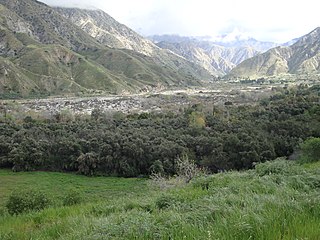
The Crescenta Valley is a small inland valley in Los Angeles County, California, lying between the San Gabriel Mountains on the northeast and the Verdugo Mountains and San Rafael Hills on the southwest. It opens into the San Fernando Valley at the northwest and the San Gabriel Valley at the southeast. It is nearly bisected by the Verdugo Wash, a smaller valley separating the Verdugo Mountains from the San Rafael Hills. Most of the valley lies at an elevation of over 1,500 feet.

The Verdugo Mountains, also known as the Verdugo Hills or simply The Verdugos, are a small, rugged mountain range of the Transverse Ranges system in Los Angeles County, California. Located just south of the western San Gabriel Mountains, the Verdugo Mountains region incorporates the cities of Glendale, Pasadena, and La Cañada Flintridge; the unincorporated communities of Altadena and La Crescenta-Montrose; as well as the City of Los Angeles neighborhood of Sunland-Tujunga.

The North Shore Mountains are a mountain range overlooking Vancouver in British Columbia, Canada. Their southernmost peaks are visible from most areas in Vancouver and form a distinctive backdrop for the city.
Mission College is a public community college in Santa Clara, California. It is part of the West Valley–Mission Community College District. The land the college is on was bought between 1966 and 1967. Mission College opened for its first year in 1975. In 1979 it had grown to "3,500 students, 8 administrators, and 73 instructors".

The Awaswas, also known as the Santa Cruz people, were a group of the Indigenous peoples of California in North America, with subgroups historically numbering about 600 to 1,400. Academic research suggests that their ancestors had lived within the Santa Cruz Mountains region for approximately 12,000 years. The Awaswas maintained regular trade networks with regional cultures before the Spanish colonists began settling in the area from the 18th century.

San Timoteo Canyon is a river valley canyon southeast of Redlands, in the far northwestern foothills of the San Jacinto Mountains in the Inland Empire region of Southern California.
Tuyunga or Tujunga is a former Tongva (Fernandeño) village now located at Sunland-Tujunga, Los Angeles in Los Angeles County, California. The village was located near the original Rancho Los Encinos that became the Mission San Fernando Rey de España in the San Fernando Valley.
Politana or Apolitana was the first Spanish settlement in the San Bernardino Valley of California. It was established as a mission chapel and supply station by the Mission San Gabriel in the a rancheria of the Guachama Indians that lived on the bluff that is now known as Bunker Hill, near Lytle Creek. Besides the Guachama, it was also at various times the home for colonists from New Mexico and Cahuilla people. Its most prominent landmark today is the St. Prophet Elias Greek Orthodox Church on Colton Avenue, just southwest of the Inland Center Mall, in San Bernardino, California.
The Saklan are a tribe of the Native American Miwok community, based just south of San Pablo and Suisun Bays, in Contra Costa County, California. Their historical tribal lands ranged from Moraga, to San Leandro Creek, to Lafayette.

The Monte Vista Hotel was a building which had been formerly located at the intersection of what today are Fenwick Street and Floralita Avenue in the Sunland-Tujunga district of Los Angeles. It was considered the first structure built in the district as well as the last surviving structure of a larger, pre-existing facility known as the Monte Vista Lodge.

The Rockhaven Sanitarium Historic District is located in the Crescenta Valley at 2713 Honolulu Avenue in what is now the City of Glendale, California. The sanitarium for which it is named was opened in 1923 by psychiatric nurse Agnes Richards as a private mental health institution for women with mild mental and nervous disorders. The property was added to the National Register of Historic Places in June 2016 and in 2021 it was announced that it would be developed into a museum.

The Crescenta Valley flood occurred in New Year's Eve 1933 and extended to New Year's 1934 in the Crescenta Valley in Los Angeles County, California, inundating communities in the valley including La Crescenta-Montrose, La Cañada, and Tujunga. This seemed to have happened because in late 1933, wildfires burned much of the trees and grass in the Crescenta Valley, leaving the cities in the lower parts of the valley vulnerable to flooding. On New Year's Eve, heavy rains led to the collapse of earthen dams, which in turn led to the destruction of many homes in the valley and many deaths.
References
- ↑ "Rediscovering our lost history — Indians of the Foothills - Crescenta Valley Weekly" . Retrieved 2023-04-23.
- 1 2 3 4 Keyes, Gary; Lawler, Mike (2013-08-20). "Chapter 1: Early Years". Murder & Mayhem in the Crescenta Valley. Arcadia Publishing. ISBN 978-1-62584-067-7.
- 1 2 3 4 5 "The Lost Indian Village of the Crescenta Valley - Crescenta Valley Weekly" . Retrieved 2023-04-23.
- ↑ Lawler, Mike (2017-11-07). "Chapter 1: Indian Springs - Hidden Beneath a Shopping Center". Crescenta Valley History: Hidden in Plain Sight. Fonthill Media.