Related Research Articles

The Tongva are an Indigenous people of California from the Los Angeles Basin and the Southern Channel Islands, an area covering approximately 4,000 square miles (10,000 km2). In the precolonial era, the people lived in as many as 100 villages and primarily identified by their village rather than by a pan-tribal name. During colonization, the Spanish referred to these people as Gabrieleño and Fernandeño, names derived from the Spanish missions built on their land: Mission San Gabriel Arcángel and Mission San Fernando Rey de España. Tongva is the most widely circulated endonym among the people, used by Narcisa Higuera in 1905 to refer to inhabitants in the vicinity of Mission San Gabriel. Some people who identify as direct lineal descendants of the people advocate the use of their ancestral name Kizh as an endonym.

The San Fernando Valley, known locally as the Valley, is an urbanized valley in Los Angeles County, California. Situated to the north of the Los Angeles Basin, it contains a large portion of the city of Los Angeles, as well as several unincorporated areas; and the incorporated cities of Burbank, Calabasas, Glendale, Hidden Hills, and San Fernando. The valley is well known for its film studios such as Warner Bros. Studios and Walt Disney Studios. In addition, it is home to the Universal Studios Hollywood theme park.

Chatsworth is a suburban neighborhood in Los Angeles, California, in the San Fernando Valley.

West Hills is an affluent residential community in the western San Fernando Valley region of the City of Los Angeles, California. The percentage of residents aged 35 and older is among the highest in Los Angeles County.

Granada Hills is a neighborhood in the San Fernando Valley region of Los Angeles. The community has a sports program and a range of city recreation centers. The neighborhood has fourteen public and ten private schools.

The Santa Susana Pass, originally Simi Pass, is a low mountain pass in the Simi Hills of Southern California, connecting the San Fernando Valley and Los Angeles neighborhood of Chatsworth, to the city of Simi Valley and eponymous valley.

The Simi Hills are a low rocky mountain range of the Transverse Ranges in eastern Ventura County and western Los Angeles County, of southern California, United States.

Stoney Point, also known as the Stoney Point Outcroppings or Chatsworth Formation, is a Los Angeles City park near the north end of Topanga Canyon Boulevard in Chatsworth, Los Angeles, California, part of the city of Los Angeles. Stoney Point is a popular destination for hikers, equestrians and also with rock climbers because of its large boulders, which afford many opportunities to practice the sport of bouldering. The top of the rock formation offers excellent views of Chatsworth, the Santa Susana Mountains, Coyote Pass, and the entire San Fernando Valley.

Rancho Los Encinos was a Spanish grazing concession, and later Mexican land granted cattle and sheep rancho and travelers way-station on the El Camino Real in the San Fernando Valley, in present-day Encino, Los Angeles County, California. The original 19th-century adobe and limestone structures and natural Encino Springs are now within the Los Encinos State Historic Park.

Santa Susana Pass State Historic Park is a California State Park of 670.68 acres (2.7141 km2) located in the city of Los Angeles, in Los Angeles County on the boundary between Ventura and Los Angeles counties, between the communities of Chatsworth and Simi Valley. Geologically, the park is located where the Simi Hills meet the Santa Susana Mountains. Here in the western part of the Transverse Ranges, the land is dominated by high, narrow ridges and deep canyons covered with an abundant variety of plant life. The park offers panoramic views of the rugged natural landscape as a striking contrast to the developed communities nearby. The park is also rich in archaeological, historical, and cultural significance.
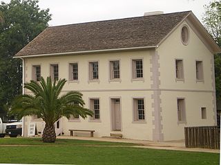
Los Encinos State Historic Park is a state park unit of California, preserving buildings of Rancho Los Encinos. The park is located near the corner of Balboa and Ventura Boulevards in Encino, California, in the San Fernando Valley. The rancho includes the original nine-room de la Ossa Adobe, the two-story limestone Garnier building, a blacksmith shop, a natural spring, and a pond. The 4.7-acre (1.9 ha) site was established as a California state park in 1949.

The Old Santa Susana Stage Road, or Santa Susana Wagon Road, is a route taken by early travelers between the San Fernando Valley and Simi Valley near Chatsworth, California, via the Santa Susana Pass. The main route climbs through what is now the Santa Susana Pass State Historic Park, with a branch in Chatsworth Park South.

The Lassen Street Olive Trees, also known as 76 Mature Olive Trees, are a Los Angeles Historic-Cultural Monument located in the Chatsworth community of the northwestern San Fernando Valley, in Los Angeles, Southern California.
The history of the San Fernando Valley from its exploration by the 1769 Portola expedition to the annexation of much of it by the City of Los Angeles in 1915 is a story of booms and busts, as cattle ranching, sheep ranching, large-scale wheat farming, and fruit orchards flourished and faded. Throughout its history, settlement in the San Fernando Valley was shaped by availability of reliable water supplies and by proximity to the major transportation routes through the surrounding mountains.

The Chatsworth Nature Preserve (CNP) is a 1,325-acre (536 ha) open-space preserve located in the northwest corner of the San Fernando Valley in Los Angeles, California, United States. The preserve contains oak woodlands, savanna, riparian areas, grassland, vernal pools, and an Ecology Pond, all of which support more than 200 bird species and numerous mammals, amphibians and reptiles.

Chatsworth Calera also called Chatsworth Reservoir Kiln Site is one of the few surviving structures of the early 1800s lime industry. This kiln marked the introduction to California of the European industrial process for vitrifying limestone building blocks which were used in the construction of the San Fernando mission and other mission buildings. The word "Calera" is Spanish for "limestone quarry" or "limekiln". Chatsworth Calera is now located in Chatsworth, Los Angeles, California. in the Chatsworth Nature Preserve. At its peak there may have been up to five kilns at the site run by native Indian laborers. Chatsworth Calera registered a California Historical Landmark No. 911.

Achooykomenga is a former settlement that was located at the site of Mission San Fernando Rey de España before it was founded in 1797. Prior to the mission's founding, in the 1780s, it functioned as a shared native settlement for an agricultural rancho of Pueblo de Los Ángeles that was worked by Ventureño Chumash, Fernandeño (Tongva), and Tataviam laborers.

Tovaangar refers to the Tongva world or homelands. It includes the greater area of the Los Angeles Basin, including the San Gabriel Valley, San Fernando Valley, northern Orange County, parts of San Bernardino County and Riverside County, and the southern Channel Islands, including San Nicholas, Santa Catalina, Santa Barbara, and San Clemente. The homelands of the Chumash are to the northwest, the Tataviam to the north, the Serrano and Cahuilla to the east, and the Acjachemen and Payómkawichum to the south.
Ceegenga was a Tongva village that was one of the closest located to San Fernando Mission at the time of its establishment by the Spanish in the late eighteenth century, possibly in the Granada Hills area. Six baptisms from the village were recorded at the mission from 1797 to 1802.
References
- 1 2 3 Crosby, Michael (2009). Encino. Arcadia Publishing. p. 9. ISBN 978-0-7385-6991-8.
- 1 2 "Stoney Point Historical Marker". www.hmdb.org. Retrieved 2023-04-20.
- ↑ McLendon, Sally (1999). Cultural Affiliation and Lineal Descent of Chumash Peoples in the Channel Islands and the Santa Monica Mountains: Final Report. National Park Service. p. 88.
- ↑ "Santa Fe Springs, CA - Volume 3". www.santafesprings.org. Retrieved 2023-04-20.
- 1 2 "A San Fernando Valley trail is one step closer to becoming a historic monument". Daily News. 2019-01-23. Retrieved 2023-04-20.
- ↑ "Los Angeles City Council votes to make the Apeta Momonga Mission Trail historic-cultural monument". Daily News. 2019-03-13. Retrieved 2023-04-20.