
Newport Beach is a coastal city in South Orange County, California. Newport Beach is known for swimming and sandy beaches. Newport Harbor once supported maritime industries however today, it is used mostly for recreation. Balboa Island draws visitors with a waterfront path and easy access from the ferry to the shops and restaurants.
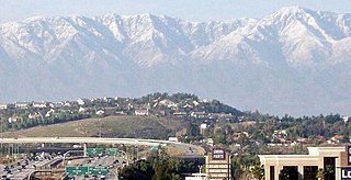
Corona is a city in Riverside County, California, United States. At the 2020 census, the city had a population of 157,136, up from 152,374 at the 2010 census. The cities of Norco and Riverside lie to the north and northeast, Chino Hills and Yorba Linda to the northwest, Anaheim to the west, Cleveland National Forest and the Santa Ana Mountains to the southwest, and unincorporated Riverside County along the rest of the city's borders. Downtown Corona is approximately 48 miles southeast of Downtown Los Angeles and 95 miles (153 km) north-northwest of San Diego.

Corona del Mar is a seaside neighborhood in the city of Newport Beach, California. It generally consists of all the land on the seaward face of the San Joaquin Hills south of Avocado Avenue to the city limits, as well as the development of Irvine Terrace, just north of Avocado. Corona del Mar is known for its beaches, tide pools, cliffside views and village shops. Beaches in the area include Corona del Mar State Beach as well as Crystal Cove State Park south of Corona del Mar, accessible by paths winding down a steep hillside. Corona del Mar has a representative to the Newport Beach City Council. Residents use a mailing address of Corona del Mar with the 92625 ZIP code.

Chino Hills State Park is a state park of California, in the United States. It is located in the Chino Hills, foothills of the Santa Ana Mountains. It is a critical link in the Chino–Puente Hills wildlife corridor, and a major botanical habitat reserve for resident and migrating wildlife.

The Santa Ana River is the largest river entirely within Southern California in the United States. It rises in the San Bernardino Mountains and flows for most of its length through San Bernardino and Riverside Counties, before cutting through the northern Santa Ana Mountains via Santa Ana Canyon and flowing southwest through urban Orange County to drain into the Pacific Ocean. The Santa Ana River is 96 miles (154 km) long, and its drainage basin is 2,650 square miles (6,900 km2) in size.

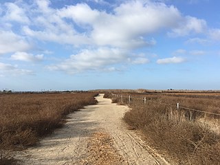
The Back Bay is the colloquial term for the inland delta in Newport Beach, California. It connects the Upper Newport Bay with the Newport Harbor. It is a nature reserve home to several species of birds with hiking and biking trails. The bay is recognized for protection by the California Bays and Estuaries Policy.

The San Joaquin Hills are a low mountain range of the Peninsular Ranges System, located in coastal Orange County, California.
Rancho Santiago de Santa Ana was a 63,414-acre (256.63 km2) Spanish land concession in present-day Orange County, California, given by Spanish Alta California Governor José Joaquín de Arrillaga in 1810 to Jose Antonio Yorba and his nephew Pablo Peralta. The grant extended eastward from the Santa Ana River to the Santa Ana Mountains, with a length of more than 22 miles (35 km).

Redonda Mesa is a mesa type formation located in the southern Santa Ana Mountains, near the Pacific Ocean in Southern California. It is located in an unincorporated area of southwestern Riverside County.

San Diego Creek is a 16-mile (26 km) urban waterway flowing into Upper Newport Bay in Orange County, California in the United States. Its watershed covers 112.2 square miles (291 km2) in parts of eight cities, including Irvine, Tustin, and Costa Mesa. From its headwaters in Laguna Woods the creek flows northwest to its confluence with Peters Canyon Wash, where it turns abruptly southwest towards the bay. Most of the creek has been converted to a concrete flood control channel, but it also provides important aquatic and riparian habitat along its course and its tidal estuary.
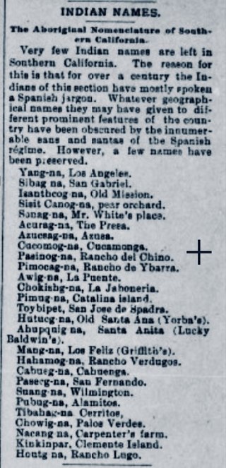
Pasinogna is a former Tongva-Gabrieleño Native American settlement in San Bernardino County, California.

Newport Bay, in Southern California is the lower bay formed along the coast below the Upper Newport Bay, after the end of the Pleistocene. It was formed by sand, brought by ocean currents from the Santa Ana River and other rivers to the north, which constructed an offshore beach, now called the Balboa Peninsula. The bay was named by the Spanish Bolsa de Gengar in the 18th century, to refer to the nearby Tongva and Acjachemen village of Genga. An estuary of the Santa Ana River in the late 19th century, it was dredged to form Newport Harbor, the harbor of Newport Beach.

Puhú was a major residential village in the Santa Ana Mountains shared by the Tongva, Acjachemen, Payómkawichum, and Serrano near Santiago Peak. The village resided approximately 600m above sea level in the upper areas of the Black Star Canyon. The village was at its height from the years 1220-1770. The village retained its multi-seasonal occupancy and economic and political systems up until its destruction and a communal massacre in 1832.
Genga, alternative spelling Gengaa and Kengaa, was a Tongva and Acjachemen village located on Newport Mesa overlooking the Santa Ana River in the Newport Beach and Costa Mesa, California area which included an open site now referred to as Banning Ranch. Archaeological evidence dates the village at over 9,000 years old. Villagers were recorded as Gebit in Spanish Mission records. The village may have been occupied as late as 1829 or 1830.
Hutuknga, alternative spelling Hotuuknga, was a large Tongva village located in the foothills along the present channel of the Santa Ana River in what is now Yorba Linda, California. People from the village were recorded in mission records as Jutucabit. Hutuknga was part of a series of villages along the Santa Ana River, which included Lupukngna, Genga, Pajbenga, and Totpavit. The Turnball Canyon area is sometimes falsely associated with Hutuknga.
Pajbenga, alternative spelling Pagbigna and Pasbengna, was a Tongva village located at Santa Ana, California, near the El Refugio Adobe, which was the home of José Sepulveda. It was one of the main villages along the Santa Ana River, including Lupukngna, Genga, Totpavit, and Hutuknga. People from the village were recorded in mission records as Pajebet, Pajbet, Pajbebet, and Pajbepet.
Totpavit, alternative spellings Totabit and possibly Totavet, was a Tongva village located in what is now Olive, California. The village was located between the Santa Ana River and Santiago Creek. It was part of a series of villages along the Santa Ana River, including Genga, Pajbenga, and Hutuknga.
Mocuachem, or alternatively spelled Mukwa'shish, Mocuache, Mocuachame, and Moquache, was a Payómkawichum village in San Diego County, California. At least 12 people were baptized by Spanish missionaries from the village as an act of Christian conversion carried out primarily at Mission San Juan Capistrano.

Lupukngna was a coastal Tongva village that was at least 3,000 years old located on the bluffs along the Santa Ana River in Huntington Beach near the Newland House Museum. Other nearby coastal villages included Genga, located in West Newport Beach, and Moyongna, located down the coast near Corona del Mar. The village has also been referred to as Lukup and Lukupa. The village has been chronicled in the history of Costa Mesa, California.
Paxauxa was a shared Tongva and Payómkawichum village site located at what is now Corona, California along Temescal Creek. Villagers may have appeared in baptismal records at Mission San Juan Capistrano as being from the village Axaxa. Nearby villages included Poruumanga and Shiishonga. It is sometimes alternatively spelled Pakhavka.
