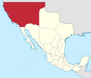
Alta California, also known as Nueva California among other names, was a province of New Spain formally established in 1804. Along with the Baja California peninsula, it had previously comprised the province of Las Californias, but was made a separate province in 1804. Following the Mexican War of Independence, it became a territory of Mexico in April 1822 and was renamed Alta California in 1824.

The Tongva are an Indigenous people of California from the Los Angeles Basin and the Southern Channel Islands, an area covering approximately 4,000 square miles (10,000 km2). In the precolonial era, the people lived in as many as 100 villages and primarily identified by their village rather than by a pan-tribal name. During colonization, the Spanish referred to these people as Gabrieleño and Fernandeño, names derived from the Spanish missions built on their land: Mission San Gabriel Arcángel and Mission San Fernando Rey de España. Tongva is the most widely circulated endonym among the people, used by Narcisa Higuera in 1905 to refer to inhabitants in the vicinity of Mission San Gabriel. Some people who identify as direct lineal descendants of the people advocate the use of their ancestral name Kizh as an endonym.

Alhambra is a city located in the western San Gabriel Valley region of Los Angeles County, California, United States, approximately eight miles from the Downtown Los Angeles civic center. It was incorporated on July 11, 1903. As of the 2020 census, the population was 82,868. The city's ZIP Codes are 91801 and 91803.

The San Gabriel Valley, often referred to by its initials as SGV, is one of the principal valleys of Southern California, with the city of Los Angeles directly bordering it to the west, and occupying the vast majority of the southeastern part of Los Angeles County. Surrounding landforms and other features include the following:

Pico-Union is a neighborhood in Central Los Angeles, California. The name "Pico-Union" refers to the neighborhood that surrounds the intersection of Pico Boulevard and Union Avenue. Located immediately west of Downtown Los Angeles, it is home to over 40,000 residents.

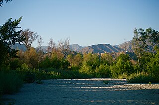
The San Gabriel River is a mostly urban waterway flowing 58 miles (93 km) southward through Los Angeles and Orange Counties, California in the United States. It is the central of three major rivers draining the Greater Los Angeles Area, the others being the Los Angeles River and Santa Ana River. The river's watershed stretches from the rugged San Gabriel Mountains to the heavily developed San Gabriel Valley and a significant part of the Los Angeles coastal plain, emptying into the Pacific Ocean between the cities of Long Beach and Seal Beach.

Wilshire Boulevard (['wɪɫ.ʃɚ]) is a prominent 15.83 mi (25.48 km) boulevard in the Los Angeles area of Southern California, extending from Ocean Avenue in the city of Santa Monica east to Grand Avenue in the Financial District of downtown Los Angeles. One of the principal east–west arterial roads of Los Angeles, it is also one of the major city streets through the city of Beverly Hills. Wilshire Boulevard runs roughly parallel to Santa Monica Boulevard from Santa Monica to the west boundary of Beverly Hills. From the east boundary, it runs a block south of Sixth Street to its terminus.

Puvunga is an ancient village and sacred site of the Tongva nation, the Indigenous people of the Los Angeles Basin, and the Acjachemen, the Indigenous people of Orange County. The site is now located within California State University, Long Beach and the surrounding area. The Tongva know Puvunga as the "place of emergence" and it is where they believed "their world and their lives began." Puvunga is an important ceremonial site and is the end to an annual pilgrimage for the Tongva, Acjachemen, and Chumash.

Barrioization is a theory developed by Chicano scholars Albert Camarillo and Richard Griswold del Castillo to explain the historical formation and maintenance of ethnically segregated neighborhoods of Chicanos and Latinos in the United States. The term was first coined by Camarillo in his book Chicanos in a Changing Society (1979). The process was explained in the context of Los Angeles by Griswold del Castillo in The Los Angeles Barrio, 1850-1890: A Social History (1979). Camarillo defined the term as "the formation of residentially and segregated Chicano barrios or neighbourhoods." The term is used in the field of Human Geography.

The Tongva Sacred Springs are a group of springs located on the campus of University High School in Los Angeles, California. The springs, called Koruuvanga by the native Gabrieleno Tongva people, were used as a source of natural fresh water by the Tongva people since at least the 5th century BC and continue to produce 22,000–25,000 US gallons (83,000–95,000 L) of water a day. The springs are also sometimes referred to as the Gabrieleno-Tongva Springs, the Tongva Holy Springs, and the Sacred Springs.
Hahamongna and Hahamog-na are two historic Tongva village sites. They are located in the Verdugo Mountains of Southern California and bear the name of the local band of indiginous Tongva, "Hahamog'na." The sites are located in present-day Pasadena and Glendale in Los Angeles County, California. Hahamongna was one of the largest Tongva villages in the greater San Fernando Valley area, along with Cahuenga, Tujunga, and Siutcanga.

The Glendale Narrows is a scenic 11 mile section of the Los Angeles River in the Northeast Los Angeles region of Los Angeles County, California.

Kaawchama, alternatively referred to as Wa’aachnga, was a significant Tongva village in the San Bernardino Valley located in what is now west Redlands, California. The village became referred to by the Spanish as the Guachama Rancheria in 1810 after a supply station was constructed at the village for Mission San Gabriel, which then became part of Rancho San Bernardino following the secularization of the missions in 1833.

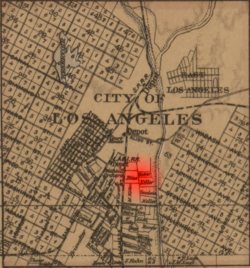
Yaanga was a large Tongva village, originally located near what is now downtown Los Angeles, just west of the Los Angeles River and beneath U.S. Route 101. People from the village were recorded as Yabit in missionary records although they were known as Yaangavit, Yavitam, or Yavitem among the people. It is unclear what the exact population of Yaanga was prior to colonization, although it was recorded as the largest and most influential village in the region.
The history of Los Angeles began in 1781 when 44 settlers from central New Spain established a permanent settlement in what is now Downtown Los Angeles, as instructed by Spanish Governor of Las Californias, Felipe de Neve, and authorized by Viceroy Antonio María de Bucareli. After sovereignty changed from Mexico to the United States in 1849, great changes came from the completion of the Santa Fe railroad line from Chicago to Los Angeles in 1885. "Overlanders" flooded in, mostly white Protestants from the Lower Midwest and South.
Totpavit, alternative spellings Totabit and possibly Totavet, was a Tongva village located in what is now Olive, California. The village was located between the Santa Ana River and Santiago Creek. It was part of a series of villages along the Santa Ana River, including Genga, Pajbenga, and Hutuknga.

Achooykomenga is a former settlement that was located at the site of Mission San Fernando Rey de España before it was founded in 1797. Prior to the mission's founding, in the 1780s, it functioned as a shared native settlement for an agricultural rancho of Pueblo de Los Ángeles that was worked by Ventureño Chumash, Fernandeño (Tongva), and Tataviam laborers.

Guashna was a Tongva village located at Playa Vista, Los Angeles at the mouth of Ballona Creek. The site has also been referred to as Sa'angna, with various sources debating whether Sa'angna, meaning "place of tar," was a regional referent rather than a village name or whether it was a separate nearby village. The initial place name was said to be Sa'an; the village suffix "ngna" was added by Bernice Johnston to her 1962 map of Gabrieleño villages "despite her having found no mention of the term in baptismal records." Sa'angna is also not to be confused with Suangna. The Tongva referred to the Ballona Wetlands as Pwinukipar, meaning "full of water." Another alternate name may Waachnga.

Tovaangar refers to the Tongva world or homelands. It includes the greater area of the Los Angeles Basin, including the San Gabriel Valley, San Fernando Valley, northern Orange County, parts of San Bernardino County and Riverside County, and the southern Channel Islands, including San Nicholas, Santa Catalina, Santa Barbara, and San Clemente. The homelands of the Chumash are to the northwest, the Tataviam to the north, the Serrano and Cahuilla to the east, and the Acjachemen and Payómkawichum to the south.
The Tongva Taraxat Paxaavxa Conservancy is an Indigenous urban land trust that formed with the objective to return or rematriate land to unrecognized Tongva descendants in the greater Los Angeles County area. It was inspired by the work of the Sogorea Te’ Land Trust and has been associated with the Land Back movement. The conservancy is notable for its part in the return of Tongva land in Los Angeles County for the first time in nearly 200 years. The trust developed a kuuyam nahwá’a or "guest exchange" program for people who live and work in the tribe's traditional homelands to financially support the land trust's goals.