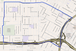
Pico-Union is a neighborhood in Central Los Angeles, California. The name "Pico-Union" refers to the neighborhood that surrounds the intersection of Pico Boulevard and Union Avenue.[1] Located immediately west of Downtown Los Angeles, it is home to over 40,000 residents.
Alvarado TerraceThe Doria Apartments, a Los Angeles Historic-Cultural Monument.
The Tongva village of Geveronga was located at the present-site of Pico-Union. It was destroyed in 1781 by Spanish settlers as part of the Anza Expedition who issued a claim to the land and water rights from King Carlos III.[6]
The area encompassed by Pico-Union was developed as a middle and upper middle class residential district beginning in the 1910s. Easy access to downtown Los Angeles and the nearby Wilshire District drew large numbers of affluent homeowners. Following the Second World War, the Pico-Union area, like many inner city neighborhoods, experienced an outflux of residents to the suburbs. The loss of residents and business led to high vacancy rates and lower property values in much of the neighborhood by the 1960s.
In the late 1970s and 1980s, the area became a major point of entry for Salvadoran and Guatemalan immigrants seeking refuge from civil war, according to the Pico Union Self-Guided Walking Tour, published in 2009 by the Los Angeles Conservancy.[7]
In August 2012, the City of Los Angeles designated a portion of Vermont Avenue in Pico-Union as El Salvador Community Corridor; parts of Pico-Union are also being considered for designation as The Central American Historical District.[8]
Pico-Union is the fourth-most-dense neighborhood in Los Angeles, surpassed only by East Hollywood, Westlake and Koreatown.[10] The 2000 U.S. census counted 42,324 residents in the 1.67-square-miles neighborhood—an average of 25,352 people per square mile. In 2008, the city estimated that the population had increased to 44,664. The median age for residents was 27, considered young for the city and the county.[3]
The ethnic breakdown in 2000 was Latinos, 85.4%; Asians, 7.6%; whites, 3.0%, blacks, 2.9%; and others, 1.1%. El Salvador (44.4%) and Mexico (23.3%) were the most common places of birth for the 64.6% of the residents who were born abroad, a figure that was considered high in comparison with foreign-born in the city as a whole.[3] Other immigrants come from Guatemala, Honduras and Nicaragua.[11]
The median household income in 2008 dollars was $26,424, considered low for both the city and the county. The percentage of households earning $20,000 or less was high, compared to the county at large. The average household size of 3.3 people was relatively high for Los Angeles. Renters occupied 90.5% of the housing units, and home- or apartment owners the rest.[3]
The percentages of never-married men (43.4%) and never-married women (36.2%) were among the county's highest. The census found 2,113 families headed by single parents, the 23.3% rate being considered high for both the city and the county.[3]
In 2000 there were 667 military veterans living in Pico-Union, or 2.3% of the population, considered a low rate for the city and the county overall.[3]
Education
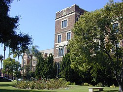
West Adams Preparatory High SchoolLoyola High SchoolTenth Street SchoolPico-Union Branch Library
Pico-Union residents aged 25 and older holding a four-year degree amounted to 6.7% of the population in 2000, considered low for both the city and the county, and there was a high percentage of residents with less than a high school diploma.[3]
Schools
These are the elementary or secondary schools within the neighborhood's boundaries:
SIATech Pico-Union is a public charter high school, 2140 West Olympic Boulevard suite 327. "Classes are held from approximately 9:00 am - 4:00 pm. This site is an independent study school where students complete work at home, online and on site."[12]
Berendo Middle School, LAUSD, 1157 South Berendo Street,[3] which claims the title as the oldest intermediate school continuously in operation in Los Angeles and perhaps in the entire United States
Sophia T. Salvin Special Education Center, LAUSD, 1925 Budlong Avenue[3]
Leo Politi Elementary School, LAUSD, 2481 West 11th Street[3]
Tenth Street Elementary School, LAUSD, 1000 Grattan Street[3]
Angelus-Rosedale Cemetery was founded as Rosedale Cemetery in 1884, when Los Angeles was a small city of around 28,000 people, on 65 acres (260,000m2) of land between Washington and Venice boulevards (then 16th Street) between Normandie Avenue and Walton and Catalina Streets.[15][16]
↑Where other reliable sources are available for the boundaries of neighborhoods, they should be treated preferentially to Google Maps and Google Street View. It is difficult if not impossible to verify as they are subject to change and documentation and archives are not available.
This page is based on this Wikipedia article Text is available under the CC BY-SA 4.0 license; additional terms may apply. Images, videos and audio are available under their respective licenses.