Related Research Articles

Mission San Gabriel Arcángel is a Californian mission and historic landmark in San Gabriel, California. It was founded by the Spanish Empire on "The Feast of the Birth of Mary," September 8, 1771, as the fourth of what would become twenty-one Spanish missions in California. San Gabriel Arcángel was named after the Archangel Gabriel and often referred to as the "Godmother of the Pueblo of Los Angeles."

Mission San Buenaventura, formally known as the Mission Basilica of San Buenaventura, is a Catholic parish and basilica in the Archdiocese of Los Angeles. The parish church in the city of Ventura, California, United States, is a Spanish mission founded by the Order of Friars Minor. Founded on March 31, 1782, it was the ninth Spanish mission established in Alta California and the last to be established by the head of the Franciscan missions in California, Junípero Serra. Designated a California Historical Landmark, the mission is one of many locally designated landmarks in downtown Ventura.

Northridge is a neighborhood in the San Fernando Valley region of the City of Los Angeles. The community is home to California State University, Northridge, and the Northridge Fashion Center.

The Tongva are an Indigenous people of California from the Los Angeles Basin and the Southern Channel Islands, an area covering approximately 4,000 square miles (10,000 km2). In the precolonial era, the people lived in as many as 100 villages and primarily identified by their village rather than by a pan-tribal name. During colonization, the Spanish referred to these people as Gabrieleño and Fernandeño, names derived from the Spanish missions built on their land: Mission San Gabriel Arcángel and Mission San Fernando Rey de España. Tongva is the most widely circulated endonym among the people, used by Narcisa Higuera in 1905 to refer to inhabitants in the vicinity of Mission San Gabriel. Some people who identify as direct lineal descendants of the people advocate the use of their ancestral name Kizh as an endonym.
Bell Gardens is a city in the U.S. state of California in the Los Angeles metropolitan area. Located in Los Angeles County, the city's population was 42,072 at the 2010 census, down from 44,054 at the 2000 census. Bell Gardens is part of the Gateway Cities Region, a largely urbanized region located in southeastern Los Angeles County.

Commerce is a city located in southeast Los Angeles County, California, United States. The population was 12,823 at the 2010 census, up from 12,568 at the 2000 census. It is usually referred to as the City of Commerce to distinguish it from the common noun. It is bordered by Vernon on the west, Los Angeles on the northwest, East Los Angeles on the north, Montebello on the east, Downey and Bell Gardens on the south, and Maywood on the southwest. The Los Angeles River forms part of its southwestern boundary, and the Rio Hondo separates it from Downey. Commerce is served by the Long Beach and Santa Ana freeways, as well as the Metrolink commuter rail service at the Commerce station.
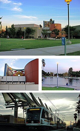
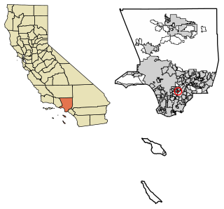
East Los Angeles, or East L.A., is an unincorporated area situated within Los Angeles County, California, United States. According to the United States Census Bureau, East Los Angeles is designated as a census-designated place (CDP) for statistical purposes. The most recent data from the 2020 census reports a population of 118,786, reflecting a 6.1% decrease compared to the 2010 population of 126,496.
The Pioneer Chicken Take Out Corporation, doing business as Pioneer Chicken, is an American fried chicken restaurant chain which was founded in Echo Park, Los Angeles in 1961 by H. R. Kaufman. During the 1970s, several locations operated in Honolulu on the island of Oahu, Hawaii. When Kaufman sold the chain in 1987, there were 270 restaurants operated by 220 franchisees. In 1993, Pioneer Chicken was taken over by AFC Enterprises, the parent company of Popeyes. Almost all Pioneer Chicken locations were then converted to Popeyes. The franchisees of two locations resisted the change, retaining the Pioneer Chicken branding: Los Angeles and Bell Gardens, California.

The San Fernando Valley, known locally as the Valley, is an urbanized valley in Los Angeles County, California. Situated northwards of the Los Angeles Basin, it comprises a large portion of Los Angeles, the incorporated cities of Burbank, Calabasas, Glendale, Hidden Hills and San Fernando, plus several unincorporated areas. The valley is the home of Warner Bros. Studios, Walt Disney Studios, and the Universal Studios Hollywood theme park.
California State University, Long Beach (CSULB), also known in athletics as Long Beach State University (LBSU), is a public research university in Long Beach, California. The 322-acre campus is the second largest in the California State University system (CSU). The university enrolls around 38,273 undergraduate students and 5,562 graduate students as of fall 2022 - one of the largest graduate student populations across the CSU system and in the state of California. CSULB is classified among "R2: Doctoral Universities – High Research Activity".

Downtown Los Angeles (DTLA) is the central business district of Los Angeles. It is part of the Central Los Angeles region and covers a 5.84 sq mi (15.1 km2) area. As of 2020, it contains over 500,000 jobs and has a population of roughly 85,000 residents, with an estimated daytime population of over 200,000 people prior to the COVID-19 pandemic.

West Hills is a neighborhood in the western San Fernando Valley region of the city of Los Angeles, California. It is bordered by mountain ranges to the west and the Los Angeles neighborhoods of Chatsworth to the north, Canoga Park to the east, and Woodland Hills to the south.
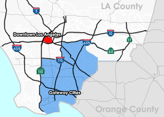
The Gateway Cities Region, or Southeast Los Angeles County, is an urbanized region located in southeastern Los Angeles County, California, between the City of Los Angeles proper, Orange County, and the Pacific Ocean. The cluster of cities has been termed "Gateway Cities" in that they serve as a "gateway" between the LA and Orange counties, with the city of Cerritos equidistant from Downtown L.A., Long Beach, and Santa Ana in Orange County. As such, the area is central to the Los Angeles-Long Beach-Anaheim, CA Metropolitan Statistical Area (MSA), and has a population of approximately 2,000,000 residents.

Weingart Stadium is a 22,355-capacity multi-purpose stadium located at East Los Angeles College, in Monterey Park, California. It was built in 1951 at a cost of $3.1 million, and following renovations in 1984 it was renamed after philanthropist Ben Weingart.
Varrio Nuevo Estrada, also known as VNE13, is a Chicano criminal street gang founded in Boyle Heights, California, in the Estrada Courts housing projects. VNE is one of 34 gangs in a 15-square-mile area east of downtown Los Angeles.

Puvunga is an ancient village and sacred site of the Tongva nation, the Indigenous people of the Los Angeles Basin, and the Acjachemen, the Indigenous people of Orange County. The site is now located within the California State University, Long Beach campus and surrounding areas. The Tongva know Puvunga as the "place of emergence" and it is where they believe "their world and their lives began". Puvunga is an important ceremonial site and is the terminus of an annual pilgrimage for the Tongva, Acjachemen, and Chumash.
Districts in California geographically divide the U.S. state into overlapping regions for political and administrative purposes.

Kenneth Hahn State Recreation Area, or Kenneth Hahn Park, is a state park unit of California in the Baldwin Hills Mountains of Los Angeles. The park is managed by the Los Angeles County Department of Parks and Recreation. As one of the largest urban parks and regional open spaces in the Greater Los Angeles Area, many have called it "L.A.'s Central Park". The 401-acre (1.62 km2) park was established in 1984. The land was previously the Baldwin Hills Reservoir, which failed catastrophically in the 1963 Baldwin Hills Dam disaster.

Village Green, originally named Baldwin Hills Village, is a neighborhood at the foot of Baldwin Hills, within the city of Los Angeles, California. Village Green consists of a large condominium complex that is both a Los Angeles Historic-Cultural Monument and a National Historic Landmark. Designed in the late 1930s and completed by 1942, it is one of the oldest planned communities of its type in the nation. Village Green was named by The American Institute of Architects as one of the 100 most important architectural achievements in U.S. history.

Geveronga was a Tongva village located at what is now Pico-Union, Los Angeles, California along the Los Angeles River. Part of the village area is also located on the campuses of the University of Southern California (USC) at its University Park Campus. The USC History Department provided a map of the general location of Geveronga in its land acknowledgement in 2021. People from the village were known as Geverovit.
References
- ↑ Facility, University of California, Berkeley Archaeological Research (1968). Reports. Department of Anthropology. p. 95.
{{cite book}}: CS1 maint: multiple names: authors list (link) - ↑ Alvarez, Albert Anthony (1993). An Ethnographic Study of Student Resistance in a Predominantly Chicano Public School. University of California, Los Angeles. p. 56.
- ↑ Verne Dyson: "The Old Ranchos That are Buried in Los Angeles" in The Los Angeles Times Sunday Magazine, issue of December 18, 1927, pp. 12-13, 23 (23), https://www.newspapers.com/image/?spot=25458857, last accessed 2 February 2019.
| | This Los Angeles County, California–related article is a stub. You can help Wikipedia by expanding it. |